1950s Maps of Klamath County, Oregon
Explore 35 historic maps of Klamath County from the 1950s. These maps offer a rare glimpse into what life looked like during the 1950s — showing old roads, neighborhoods, homes, and landmarks that have changed or disappeared over time.
Whether you're researching your family's past, planning a metal detecting trip, or studying how Klamath County's landscape evolved across the 1950s, these high-resolution maps are a powerful tool for exploring the history of this region.
- Focus on a specific era: All maps on this page are from the 1950s, giving you a focused view of this time period.
- See what’s changed: Compare century-old streets, trails, and buildings to today's modern landscape using overlays and satellite layers.
- Research with precision: Use these maps for genealogy, historical research, land use analysis, or educational projects.
- View, download, or print: Maps are fully viewable online in high resolution, and can be downloaded or printed for your own records.
Start exploring Klamath County's history through authentic maps from the 1950s. This is your window into the past.
Klamath County, OR maps
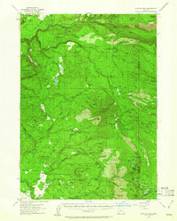
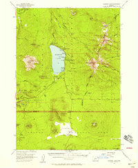
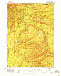
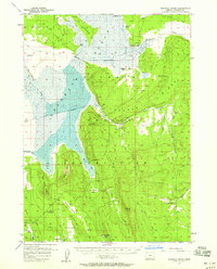
(35)- 1950 Map of Mt. Dome, 1952 Print
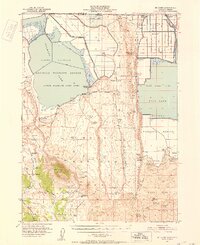 1950 Mt. Dome1952 Print · USGSUpper Klamath Basin life in the mid-century shows a landscape of reclamation and deep history at the Oregon-California border. Trace early ranching and water management at Chalk Bank Landing, the Winema Sch, and the Tulelake Tunnel.4 unique versions available
 - 1951 Map of Clear Lake Reservoir, 1952 Print
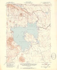 1951 Clear Lake Reservoir1952 Print · USGSModoc County's high-desert basins and water systems are captured in the early fifties, just as the wildlife refuge and reservoir reached their modern configuration. Researchers can trace the historic Emigrant Trail or locate legacy ranching sites like McNeil Ranch and Chandler Ranch.5 unique versions available
 - 1951 Map of Tulelake, 1953 Print
 1951 Tulelake1953 Print · USGSTule Lake and the Modoc plateau are captured in the early fifties during the height of the region's agricultural development. Genealogists and historians can trace the legacy of family ranching at Old Elliot Ranch or locate the historic Battle of Lands Ranch (Site) and Carr School.4 unique versions available
 - 1954 Map of Alturas, 1968 Print
 1954 Alturas1968 Print · USGSThe Modoc Plateau and Surprise Valley appear in the mid-1950s as a landscape of remote ranching towns and vast wildlife refuges. Researchers can trace early settlements like Fort Bidwell, locate the McArthur Grain Elevator, and follow the Southern Pacific rail lines.4 unique versions available
 - 1955 Map of Lake O' Woods, 1957 Print
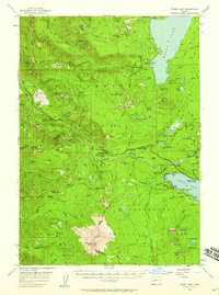
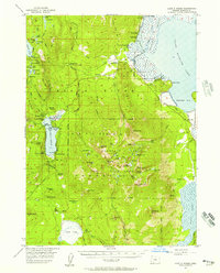 1955 Lake O' Woods1957 Print · USGSThe Oregon Cascades and the shores of Upper Klamath Lake are captured here in the mid-fifties, during the height of the region's recreational growth. Researchers can locate early camps and lodges like Harriman Lodge, Long Lake Camp, and the Lake O' Woods Resort.3 unique versions available
 - 1955 Map of Surveyor Mtn, 1957 Print
 1955 Surveyor Mtn1957 Print · USGSThe Oregon-California borderlands were a hub of timber and river activity in the mid-1950s, characterized by high forest ridges and rugged canyon bends. Genealogists and historians can locate family landmarks like Spencer Cemetery, 41 Ranch, and the winding Lumber Railroad.3 unique versions available
 - 1955 Map of Rustler Peak, 1957 Print
 1955 Rustler Peak1957 Print · USGSEastern Jackson County is shown here in the mid-fifties, dominated by timber operations and family ranching during a period of transition. Researchers can locate specific family lands like Thomson Ranch and landmarks including the Copco Powerhouse and Mt Pitt Sch (Aban'd).3 unique versions available
 - 1955 Map of Hyatt Reservoir, 1957 Print
 1955 Hyatt Reservoir1957 Print · USGSSouthern Oregon and the California borderlands are mapped here in the mid-fifties, capturing a landscape of high-altitude ranching and forest management. Researchers can trace historic homesteads like Schoolhouse Ranch or the small settlement of Lincoln near its mountain millpond.3 unique versions available
 - 1955 Map of Mt. Mc Loughlin, 1957 Print
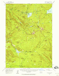
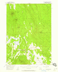
 1955 Mt. Mc Loughlin1957 Print · USGSThe Southern Cascades near the Jackson and Klamath county line are shown here in the mid-fifties, dominated by the peak of Mt McLoughlin. Researchers can trace old timber and water infrastructure at Deadwood, Swede Cabin, and the Big Elk Guard Station.3 unique versions available
 - 1955 Map of Pelican Butte, 1957 Print
 1955 Pelican Butte1957 Print · USGSThe Southern Cascades and Klamath Basin meet in the mid-1950s, showing the transition from mountain forests to valley marshlands. Researchers can locate established camps and backcountry infrastructure like McKie Camp, the Sevenmile Guard Station, and the Ft Klamath Elementary Sch.3 unique versions available
 - 1955 Map of Crescent, 1963 Print
 1955 Crescent1963 Print · USGSCentral Oregon in the mid-1950s was a landscape of dense national forests and high desert expanses. Researchers can trace timber-era settlements like Gilchrist and Crescent or locate remote outposts such as Stauffer and Millican near the Wagontire Mountains.3 unique versions available
 - 1955 Map of Klamath Falls, 1963 Print
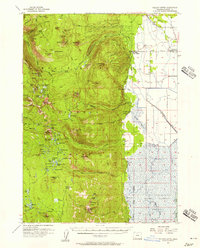
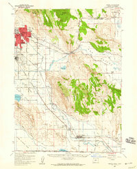
 1955 Klamath Falls1963 Print · USGSSouthern Oregon's high desert and timber country are captured here during the mid-fifties, showing the rail-dependent economies of the basin. Genealogists and researchers can locate old outposts like the Keno Guard Station, the Bly Ranger Station, and the campus of the Oregon Technical Institute.4 unique versions available
 - 1955 Map of Medford, 1964 Print
 1955 Medford1964 Print · USGSSouthern Oregon's valley towns and high peaks are captured here in the mid-1950s, showing the region before the completion of the modern interstate system. Genealogists and historians can trace the development of timber and mining outposts from Wolf Creek to Butte Falls and the early roads to Crater Lake.3 unique versions available
 - 1956 Map of Diamond Lake, 1958 Print
 1956 Diamond Lake1958 Print · USGSDiamond Lake and the high Cascades are shown in the mid-fifties during the peak of post-war forest recreation development. Researchers can locate early seasonal sites like Two Bear Cr Forest Camp and trace the northern reaches of the Pumice Desert.3 unique versions available
 - 1956 Map of Waldo Lake, 1958 Print
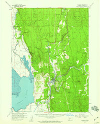
 1956 Waldo Lake1958 Print · USGSThe high Cascades at the mid-point of the century were a realm of alpine lakes and steam-age rail routes. Genealogists and historians can trace old camps and stations along the Southern Pacific Railroad, from Beamer Ranch to the Cascade Summit overlook.3 unique versions available
 - 1956 Map of Summit Lake, 1958 Print
 1956 Summit Lake1958 Print · USGSThe Oregon Cascades during the mid-fifties reveal a landscape of expanding mountain access and hydraulic engineering. You can trace early forest camps like Emigrant Forest Camp and the construction of the Umpqua Canal near the high waters of Summit Lake.3 unique versions available
 - 1956 Map of Garwood Butte, 1958 Print
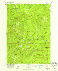 1956 Garwood Butte1958 Print · USGSThe Douglas and Klamath county high country is captured here during the mid-1950s, showing the intersection of three major federal land reserves. Genealogists and historians can trace old forest outposts and trail networks, from the Big Camas Ranger Sta to the Old Man Camp and Toketee Airstrip.3 unique versions available
 - 1956 Map of Prospect, 1958 Print
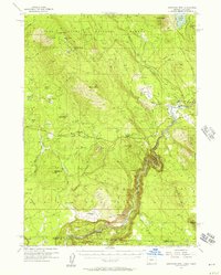
 1956 Prospect1958 Print · USGSThe high timber country of the Cascades is captured here during the mid-1950s, showing the intersection of national forest management and early tourism. Genealogists and historians can locate remote outposts like Skeeters Camp, the Huckleberry Guard Station, and Union Creek.3 unique versions available
 - 1956 Map of Calimus Butte, 1959 Print
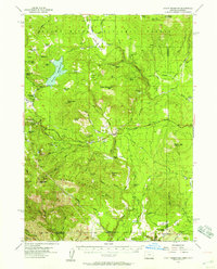
 1956 Calimus Butte1959 Print · USGSThe high timberlands and volcanic peaks of Klamath County are documented here in the mid-1950s. Trace the working landscape of the Sprague River valley to locate the McCready Ranch or the remains of the Ray Ranch (Ruins).2 unique versions available
 - 1957 Map of Crescent
 1957 Crescent1957 Print · USGSCentral Oregon’s high desert and volcanic rim are captured here in the late fifties, showing the region before the modernization of its wilderness corridors. Genealogists and local historians can trace rail-line outposts like Chemult and the early boundaries of the Klamath Indian Reservation.
 - 1957 Map of Medford
 1957 Medford1957 Print · USGSSouthern Oregon during the mid-fifties is captured here as a region of growing valley cities and vast timberlands. Genealogists and historians can trace the rail-and-road corridors connecting Medford, Jacksonville, and Grants Pass to more remote locales like Wolf Creek or Butte Falls.
 - 1957 Map of Merrill, 1959 Print
 1957 Merrill1959 Print · USGSThe Klamath Basin comes into sharp focus during the late fifties as irrigation and rail infrastructure reshaped the high desert. Researchers can trace the routes of the Southern Pacific, find early school sites like Shasta School, and locate the historic Stone Bridge crossing.2 unique versions available
 - 1957 Map of Chiloquin, 1959 Print
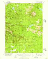
 1957 Chiloquin1959 Print · USGSKlamath County at the end of the 1950s shows a landscape of river-valley settlements and reservation lands. Researchers can trace the history of Fort Klamath, locate the Williamson River Mission, and find smaller sites like Braymill and the Wilson Cem.3 unique versions available
 - 1957 Map of Klamath Marsh, 1959 Print
 1957 Klamath Marsh1959 Print · USGSKlamath County in the late fifties shows a landscape of expansive wetlands and high ridges defined by ranching outposts and historic crossings. Researchers can trace the Military Crossing through Klamath Marsh or locate sites like Lamm Camp and Kittridge Ranch.2 unique versions available
 - 1957 Map of Swan Lake, 1959 Print
 1957 Swan Lake1959 Print · USGSThe Klamath basin in the late fifties was a landscape of high plateaus and ranching valleys served by the California and Oregon Eastern railroad. Local historians can locate specific family landmarks like Gabriel Cem, Horton, and the early campus of the Oregon Technical Institute.3 unique versions available
Showing maps 1-25 of 35
Top cities of Klamath County
- Klamath Falls historical maps
- Altamont historical maps
- Merrill historical maps
- Chiloquin historical maps
- Malin historical maps
- Bonanza historical maps
Frequently asked questions
- What are the different types of historical maps available for Klamath County?
- What is the oldest map of Klamath County?
- Where can I purchase historical maps of Klamath County for my home or office?
- Where can I download high-res historical maps of Klamath County?
- Are there historical topographic maps available for Klamath County?
- Is there historical aerial imagery available for Klamath County?
- Where are historical maps of Klamath County sourced from?