1960s Maps of Lake County, Oregon
Explore 95 historic maps of Lake County from the 1960s. These maps offer a rare glimpse into what life looked like during the 1960s — showing old roads, neighborhoods, homes, and landmarks that have changed or disappeared over time.
Whether you're researching your family's past, planning a metal detecting trip, or studying how Lake County's landscape evolved across the 1960s, these high-resolution maps are a powerful tool for exploring the history of this region.
- Focus on a specific era: All maps on this page are from the 1960s, giving you a focused view of this time period.
- See what’s changed: Compare century-old streets, trails, and buildings to today's modern landscape using overlays and satellite layers.
- Research with precision: Use these maps for genealogy, historical research, land use analysis, or educational projects.
- View, download, or print: Maps are fully viewable online in high resolution, and can be downloaded or printed for your own records.
Start exploring Lake County's history through authentic maps from the 1960s. This is your window into the past.
Lake County, OR maps
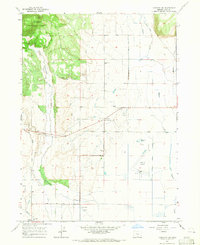
(95)- 1960 Map of Riverbed Butte, 1961 Print
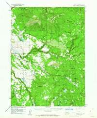
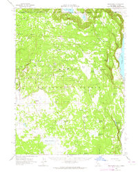
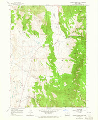
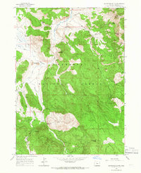
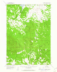 1960 Riverbed Butte1961 Print · USGSKlamath and Lake counties are shown here in the early sixties, highlighting a remote wilderness of high-desert forests and marshes. Researchers can trace historic family holdings and industrial traces such as McCartie Ranch, Obenchain Ranch, and an Old Logging Railroad.2 unique versions available
 - 1960 Map of Sycan Marsh, 1961 Print
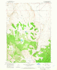
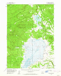 1960 Sycan Marsh1961 Print · USGSLake County ranching and timber lands are captured here during the early sixties, showing the vast Sycan Marsh before modern changes. Researchers can trace the Logging Railroad and locate established family holdings like Z X Ranch and Bratton Ranch.2 unique versions available
 - 1960 Map of Strawberry Butte, 1961 Print
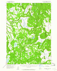 1960 Strawberry Butte1961 Print · USGSLake County ranching and forest service life are captured here at the start of the 1960s, spanning the border into California. Researchers can trace historic family-named outposts like Hunt Ranch and Reed Ranch, or locate forest infrastructure such as the Barnes Valley Guard Station and the Old Stage Road.2 unique versions available
 - 1960 Map of Fuego Mountain, 1962 Print
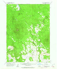 1960 Fuego Mountain1962 Print · USGSUpper Klamath County is shown here in the early sixties, a landscape of high forests and sprawling meadows defined by the headwaters of the Sprague and Sycan rivers. Researchers can locate remote outposts like Yamsay Ranch and family-named landmarks such as Buckmaster Point and Teddy Powers Meadow.2 unique versions available
 - 1960 Map of Fishhole Mtn, 1962 Print
 1960 Fishhole Mtn1962 Print · USGSThe high timber and ranching country of southern Oregon is documented here during the early sixties, showing the transition from rail-based logging to forest management. Genealogists and researchers can find remote outposts like Swede Cabin, the Mitchell Monument, and ancient Indian Petroglyphs.2 unique versions available
 - 1960 Map of Yamsay Mountain, 1968 Print
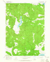
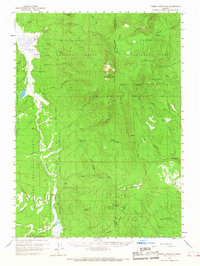 1960 Yamsay Mountain1968 Print · USGSThe high timberlands of the Cascades transition into the Klamath Basin during the early 1960s. Researchers can locate remote legacy sites like Lamms Camp (Site) and trace early travel routes along the Old Indian Reservation Boundary Road.
 - 1962 Map of Alturas
 1962 Alturas1962 Print · USGSThe high desert of Modoc and Siskiyou counties is shown in the early sixties as a hub of timber, rail, and agriculture. Genealogists and historians can trace rail-side life via the Southern Pacific RR, the Tionesta PO, and the McArthur Grain Elevator.
 - 1962 Map of Vya
 1962 Vya1962 Print · USGSThe Nevada and Oregon borderlands in the early sixties reveal a landscape of isolated ranching outposts and high-desert mining. Researchers can trace historic family holdings like the Denio Ranch or locate early mineral sites including the Mcadoo Mine and Iron King Mine.
 - 1962 Map of Adel, 1963 Print
 1962 Adel1963 Print · USGSSoutheastern Oregon in the early sixties reveals a landscape of massive basins, remote ranches, and expansive wildlife refuges. Researchers can locate vanished rural infrastructure like the Trout Creek School or trace early routes through Adel and Frenchglen.
 - 1962 Map of Willow Ranch, 1964 Print
 1962 Willow Ranch1964 Print · USGSNear the Oregon border in the early sixties, this area shows the intersection of high-desert ranching and mountain forestry. Researchers can find family-named sites like Lakeshore Ranch, the State Line School, and the historic Site of Fandango Pass Massacre.2 unique versions available
 - 1962 Map of Steele Swamp, 1964 Print
 1962 Steele Swamp1964 Print · USGSNortheastern California rangelands and the Oregon borderlands come alive in the early sixties, showing a landscape shaped by remote ranching and forest management. Trace family-named outposts like Grohs Ranch or find administrative markers like the State Line Guard Sta and Crowder Flat Ranger Station.2 unique versions available
 - 1962 Map of South Mountain, 1964 Print
 1962 South Mountain1964 Print · USGSThe Modoc Plateau at the California and Oregon border comes into focus in the early sixties, showing a landscape of high-elevation ranching and forestry. Researchers can trace remote cabins and water works like Pease Cabin, Cove Ranch, and McGinty Reservoir across the timbered ridges.2 unique versions available
 - 1962 Map of Fort Bidwell, 1964 Print
 1962 Fort Bidwell1964 Print · USGSIn the early 1960s, the high desert and mountains of northeastern Modoc County remained a landscape of remote ranches and old mining claims. Researchers can trace the layout of the Fort Bidwell Indian Reservation, locate historical mining sites like the Morrel Mine, and find family landmarks such as Scammons Arrowhead Ranch.2 unique versions available
 - 1963 Map of Spring Butte, 1965 Print
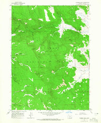
 1963 Spring Butte1965 Print · USGSDeschutes National Forest in the early sixties reveals a landscape shaped by volcanic buttes and remote forest service stations. Trace the network of trails leading to Jones Well Guard Station, the Cinder Pit, and the fire lookout at Lookout Spring Butte.2 unique versions available
 - 1964 Map of Lakeview NE, 1965 Print
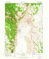
 1964 Lakeview NE1965 Print · USGSLakeview sits at the edge of the high timber in the mid-1960s, serving as a vital hub for the rail and ranching country of southern Oregon. Genealogists and local historians can trace the town's growth through several local schools, the Sunset Cem, and landmarks like Hunters Hot Sprs and the Southern Pacific line.
 - 1964 Map of Drews Reservoir, 1965 Print
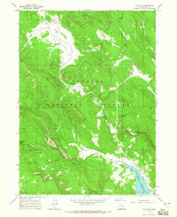
 1964 Drews Reservoir1965 Print · USGSDrews Reservoir and the high valley ranchlands of Lake County are captured here in the mid-1960s. Researchers can trace historic backcountry routes like the Salt Springs Road and locate remote landmarks such as Hay Creek Ranch and La Sere Point.3 unique versions available
 - 1964 Map of Crooked Creek Valley, 1965 Print
 1964 Crooked Creek Valley1965 Print · USGSLake County, Oregon ranching and timber lands are captured here in the mid-1960s before the modernization of forest access. Genealogists and researchers can trace family-named sites like Kittleson Place, Rehart Ranch, and Weir Ranch along the Crooked Creek corridor.
 - 1964 Map of Valley Falls, 1965 Print
 1964 Valley Falls1965 Print · USGSValley Falls and the high-desert ranges of Lake County are captured in the mid-1960s, showing a landscape defined by ranching and forest management. Researchers can locate remote sites like the Loveless Homestead, Simms Ranch, and landmarks within Chandler State Park.2 unique versions available
 - 1964 Map of Lakeview SW, 1965 Print
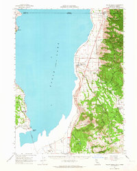
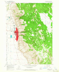
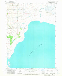 1964 Lakeview SW1965 Print · USGSGoose Lake and its marshy western shoreline are the focus of this Oregon survey from the early sixties. Researchers can trace the rural infrastructure of West Side and locate various family-scale landmarks like the Corral or the course of Thomas Creek.2 unique versions available
 - 1964 Map of Cox Flat, 1965 Print
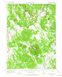
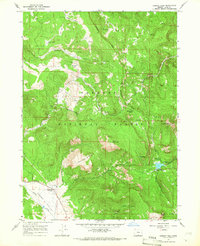
 1964 Cox Flat1965 Print · USGSThis mid-century survey of the Oregon high country captures the Fremont National Forest during a period of active mining and mountain recreation. Researchers can trace the layout of the White King Mine, the shores of Paradise Lake, and the remote Irishmans Campground.4 unique versions available
 - 1964 Map of Lakeview NW, 1965 Print
 1964 Lakeview NW1965 Print · USGSLake County agriculture and aviation come together in the mid-1960s as the Goose Lake Valley expands. Genealogists and historians can trace legacy properties like Lehmann Ranch, local rural education at Vernon Sch, and the layout of Lakeview Airport.
 - 1964 Map of Dog Lake, 1965 Print
 1964 Dog Lake1965 Print · USGSLake County high country in the mid-1960s was a landscape of remote work centers and high-desert hydrology. Genealogists and local historians can trace family-named landmarks and water sources like Ross Ranch, McCoin Creek, and Scotts Cabin Spring.2 unique versions available
 - 1964 Map of Coleman Point, 1965 Print
 1964 Coleman Point1965 Print · USGSThe high timberlands of Lake County are captured in the mid-1960s, showing a landscape of forest management and remote ranching. Researchers can trace land use through named sites like Anderson Ranch, the Dairy Creek Guard Sta, and the rugged trails surrounding Coleman Point.2 unique versions available
 - 1964 Map of Cougar Peak, 1966 Print
 1964 Cougar Peak1966 Print · USGSLake County, Oregon, is captured in the mid-1960s as a landscape of forest management and high-country ranching. Researchers can trace the OLD RAILROAD GRADE through the timber or locate the Drews Valley Ranch and Lucky Camp.2 unique versions available
 - 1964 Map of Shoestring Butte, 1966 Print
 1964 Shoestring Butte1966 Print · USGSLake County high country in the mid-1960s shows a landscape of federal forestry and early radio infrastructure. Trace the network of timber access roads and mountain outposts, from the Shoestring Butte Lookout Tower to the Thomas Creek Work Center.2 unique versions available
Showing maps 1-25 of 95
Top cities of Lake County
Frequently asked questions
- What are the different types of historical maps available for Lake County?
- What is the oldest map of Lake County?
- Where can I purchase historical maps of Lake County for my home or office?
- Where can I download high-res historical maps of Lake County?
- Are there historical topographic maps available for Lake County?
- Is there historical aerial imagery available for Lake County?
- Where are historical maps of Lake County sourced from?