1990s Maps of Lake County, Oregon
Explore 24 historic maps of Lake County from the 1990s. These maps offer a rare glimpse into what life looked like during the 1990s — showing old roads, neighborhoods, homes, and landmarks that have changed or disappeared over time.
Whether you're researching your family's past, planning a metal detecting trip, or studying how Lake County's landscape evolved across the 1990s, these high-resolution maps are a powerful tool for exploring the history of this region.
- Focus on a specific era: All maps on this page are from the 1990s, giving you a focused view of this time period.
- See what’s changed: Compare century-old streets, trails, and buildings to today's modern landscape using overlays and satellite layers.
- Research with precision: Use these maps for genealogy, historical research, land use analysis, or educational projects.
- View, download, or print: Maps are fully viewable online in high resolution, and can be downloaded or printed for your own records.
Start exploring Lake County's history through authentic maps from the 1990s. This is your window into the past.
Lake County, OR maps
(24)- 1990 Map of Beaver Mountain
 1990 Beaver Mountain1990 Print · USGSThe high borderlands of California and Oregon are mapped here in the late twentieth century, showing the intersection of two National Forests. Researchers can locate remote homesteading sites and survey markers like the Grizzlie Place (Site), Beaver Dam (Cabin), and State Bdy Mon #32.
 - 1990 Map of Lake Annie
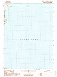
 1990 Lake Annie1990 Print · USGSThe high borderlands of Modoc County come into focus in this late twentieth-century study of the California-Oregon line. Researchers can trace historic water rights and ranching boundaries through features like Schadler Ditch and the Scammons Arrowhead Ranch.
 - 1990 Map of Weed Valley
 1990 Weed Valley1990 Print · USGSHigh-country ranching and forest management define this borderland between California and Oregon as it appeared in the late 1980s. Local researchers can locate water-security landmarks like Baseball Reservoir and historic sites such as Weed Valley Ranch.
 - 1990 Map of Steele Swamp
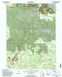
 1990 Steele Swamp1990 Print · USGSThe California-Oregon borderlands come into focus in the 1990s, where high-desert ranching meets the timberlands of the Modoc and Fremont National Forests. Researchers can trace land use at Grohs Ranch and Steele Swamp Ranch or locate boundary monuments along Steele Swamp.
 - 1990 Map of West of Willow Ranch
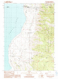
 1990 West of Willow Ranch1990 Print · USGSThe Oregon and California border along the western shore of Goose Lake is captured in the late twentieth century. Researchers can trace land use at the state line, from the timber history of Log Landing to the established Point Ranch.
 - 1990 Map of Mount Bidwell
 1990 Mount Bidwell1990 Print · USGSFort Bidwell and the surrounding high country at the California-Oregon border are documented here in the final decade of the century. Genealogists and historians can locate the Fort Bidwell Indian Reservation and numerous remote mining sites like the Madge Mines and Klondyke Mines.
 - 1990 Map of Pease Flat
 1990 Pease Flat1990 Print · USGSThe California-Oregon state line crosses the high ranchlands and lake basins of Modoc County during the late twentieth century. Researchers can trace land use patterns across the X L Ranch Indian Reservation and identify family holdings like Everly Ranch and Pease Cabin.
 - 1990 Map of Willow Ranch
 1990 Willow Ranch1990 Print · USGSThe California-Oregon borderlands come alive in this 1990 survey of the Goose Lake shoreline and the timbered slopes of the Warner Mountains. Genealogists and local historians can trace the foundations of Willow Ranch or locate family sites near Fairport and the Willow Ranch Cem.
 - 1993 Map of Burns
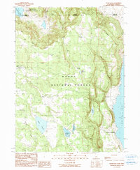
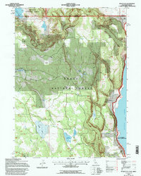
 1993 Burns1993 Print · USGSThe Harney County high desert and timbered uplands are captured here in the early nineties, centered on the ranching hubs of Burns and Hines. Trace the vital water systems of the Silvies River and Chickahominy Reservoir alongside landmarks like Wagontire Mountain.
 - 1993 Map of Mount Bidwell, 1996 Print
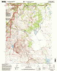
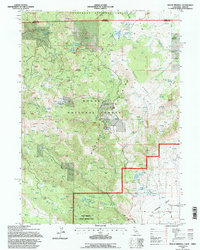 1993 Mount Bidwell1996 Print · USGSThe Warner Mountains and the northern Surprise Valley are captured here in the early 1990s, revealing a landscape of high-country mining and remote ranches. Geologists and local historians can trace the locations of the Sunshine Mine, Fort Bidwell Airport, and the Fort Bidwell Indian Reservation.
 - 1993 Map of Weed Valley, 1996 Print
 1993 Weed Valley1996 Print · USGSThe interstate borderlands of California and Oregon appear here in the early 1990s as a landscape of managed forests and ranching flats. Researchers can trace remote settlements and water sites like Weed Valley Ranch, Crowder Flat, and the curiously named Baseball Reservoir.2 unique versions available
 - 1993 Map of Steele Swamp, 1996 Print
 1993 Steele Swamp1996 Print · USGSThe high desert borderlands of Modoc County come alive in this early nineties survey of ranching and forest life. Researchers can trace the water systems of Fourmile Reservoir and locate family-held lands like the Steele Swamp Ranch and Grobe Ranch.
 - 1993 Map of Beaver Mountain, 1996 Print
 1993 Beaver Mountain1996 Print · USGSThe Oregon-California borderlands were meticulously mapped in the early nineties, revealing a landscape of high timber and seasonal camps. You can trace early land use and water sources through landmarks like the Beaver Dam Cabin, Grizzly Place (Site), and Homestead Well.
 - 1993 Map of Lake Annie, 1996 Print
 1993 Lake Annie1996 Print · USGSNortheastern California meets the Oregon border in the early nineties, where high-altitude ranching and forest lands converge. Researchers can trace water management and livestock history at the Scammons Arrowhead Ranch and the seasonal basins of Cow Head Lake.2 unique versions available
 - 1993 Map of Willow Ranch, 1996 Print
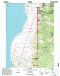 1993 Willow Ranch1996 Print · USGSNear the California-Oregon border in the early nineties, the eastern shore of Goose Lake supported a landscape of mountain forests and lakeside ranching. Genealogists and local historians can trace family-named sites like Willow Ranch Cem, the Fairport (Site), and the historic State Line Sch.
 - 1993 Map of West of Willow Ranch, 1997 Print
 1993 West of Willow Ranch1997 Print · USGSThe western shores of GOOSE LAKE are captured here during the 1990s as the water met the edge of the Modoc National Forest. Researchers can trace old lakeside footprints at Point Ranch and the forest activity at Log Landing.
 - 1993 Map of Pease Flat, 1997 Print
 1993 Pease Flat1997 Print · USGSModoc County and Lake County lands meet along the high desert shoreline of Goose Lake during the early nineties. Researchers can trace historic ranching boundaries and water systems at Everly Ranch, Pease Cabin, and the XL Ranch Indian Reservation.
 - 1994 Map of Adel
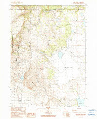
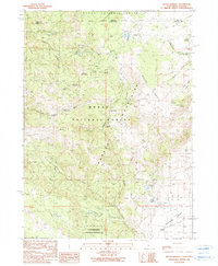
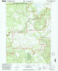
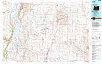 1994 Adel1994 Print · USGSLake County and Harney County are captured here in the mid-1990s, revealing a landscape defined by high desert refuges and alkaline basins. Researchers can trace remote landmarks like Mustang Jail, the Langdell Monument, and the isolated outposts of Adel and Plush.
 - 1994 Map of Harney Lake
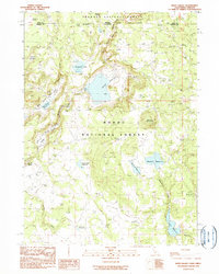
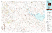 1994 Harney Lake1994 Print · USGSHigh-desert ranching and wildlife conservation define this Oregon landscape in the mid-1990s. Researchers can trace the water levels of Harney Lake and locate isolated homesteads like Frank Schmidt Ranch or the small settlement at Wagontire.
 - 1994 Map of Bluejoint Lake
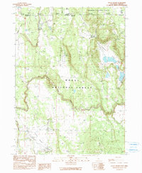
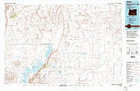 1994 Bluejoint Lake1994 Print · USGSThe high desert of Lake and Harney Counties is revealed here in the mid-1990s, dominated by the great alkaline basins and volcanic rims of the Great Basin. Researchers can trace remote sites like Old Jims and the Beckley (Site) near Bluejoint Lake.2 unique versions available
 - 1998 Map of Silver Dollar Flat, 2000 Print
 1998 Silver Dollar Flat2000 Print · USGSUpper Klamath County in the late nineties is a landscape of high-altitude forests and vital mountain springs. Researchers can trace the headwaters of the Williamson River and locate remote landmarks like Teddy Powers Meadow, Cordelia, and Pelican Reservoir.
 - 1998 Map of Riverbed Butte Spring, 2000 Print
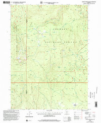
 1998 Riverbed Butte Spring2000 Print · USGSThe borderlands of Klamath and Lake Counties come alive in this late-nineties forest survey of the Oregon high country. Researchers can trace forest service history at the Sycan Fire Guard Station and locate essential water sources like Riverbed Butte Spring and Marsh Reservoir.
 - 1999 Map of Rodman Rock, 2002 Print
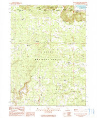
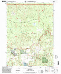
 1999 Rodman Rock2002 Print · USGSThe Oregon high desert meets the forest fringe in the late nineties, documenting the remote livestock and forestry landscape of Lake County. Researchers can locate McKinley Ranch, follow the track to Antelope Cow Camp, and trace water sources like Bear Spring.
 - 1999 Map of Yamsay Mountain, 2002 Print
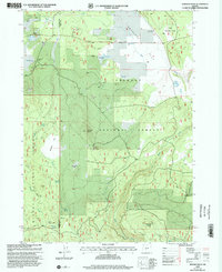
 1999 Yamsay Mountain2002 Print · USGSThe Oregon high country at the turn of the millennium reveals a landscape of high ridges and vital water sources where Klamath and Lake Counties meet. Researchers can trace the drainage of Bridge Creek and Deep Creek or locate the high-altitude Cinder Pit and Calahan Meadow.
End of results
Showing maps 1-24 of 24
Top cities of Lake County
Frequently asked questions
- What are the different types of historical maps available for Lake County?
- What is the oldest map of Lake County?
- Where can I purchase historical maps of Lake County for my home or office?
- Where can I download high-res historical maps of Lake County?
- Are there historical topographic maps available for Lake County?
- Is there historical aerial imagery available for Lake County?
- Where are historical maps of Lake County sourced from?