1970s Maps of Morrow County, Oregon
Explore 4 historic maps of Morrow County from the 1970s. These maps offer a rare glimpse into what life looked like during the 1970s — showing old roads, neighborhoods, homes, and landmarks that have changed or disappeared over time.
Whether you're researching your family's past, planning a metal detecting trip, or studying how Morrow County's landscape evolved across the 1970s, these high-resolution maps are a powerful tool for exploring the history of this region.
- Focus on a specific era: All maps on this page are from the 1970s, giving you a focused view of this time period.
- See what’s changed: Compare century-old streets, trails, and buildings to today's modern landscape using overlays and satellite layers.
- Research with precision: Use these maps for genealogy, historical research, land use analysis, or educational projects.
- View, download, or print: Maps are fully viewable online in high resolution, and can be downloaded or printed for your own records.
Start exploring Morrow County's history through authentic maps from the 1970s. This is your window into the past.
Morrow County, OR maps
(4)- 1970 Map of Alderdale, 1972 Print
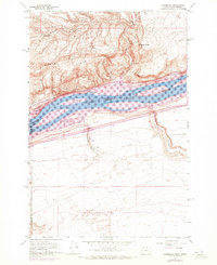 1970 Alderdale1972 Print · USGSThe Columbia River corridor comes alive in the early seventies as a hub of rail activity and industrial transit. Trace the riverbank routes of the Union Pacific and Burlington Northern near Alderdale and Golgotha Butte.
 - 1970 Map of Wolf Hollow Falls, 1973 Print
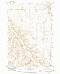 1970 Wolf Hollow Falls1973 Print · USGSThe high desert of North Central Oregon is captured here in the early 1970s, showing a landscape defined by deep canyons and dryland farming. Researchers can locate the Earl Snell Birthplace Historical Monument, a remote Cem, and the namesake Wolf Hollow Falls.
 - 1970 Map of Devils Gap, 1973 Print
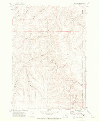 1970 Devils Gap1973 Print · USGSNorth-central Oregon's high plateau country is captured here in the early seventies, showing a landscape of deep canyons and isolated water sources. Researchers can trace the rugged drainage of Rock Creek or locate local landmarks like Ghost Camp and Box Elder Spring.
 - 1970 Map of Lone Rock Creek, 1973 Print
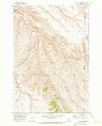 1970 Lone Rock Creek1973 Print · USGSGilliam and Morrow counties are shown during the early seventies, a time when the high desert landscape was navigated largely by primitive tracks. Researchers can trace historic access routes via the Jeep Trail network near McPherson Canyon and Billy Canyon.
End of results
Showing maps 1-4 of 4
Top cities of Morrow County
- Boardman historical maps
- Irrigon historical maps
- Heppner historical maps
- Ione historical maps
- Lexington historical maps
Frequently asked questions
- What are the different types of historical maps available for Morrow County?
- What is the oldest map of Morrow County?
- Where can I purchase historical maps of Morrow County for my home or office?
- Where can I download high-res historical maps of Morrow County?
- Are there historical topographic maps available for Morrow County?
- Is there historical aerial imagery available for Morrow County?
- Where are historical maps of Morrow County sourced from?