1980s Maps of Morrow County, Oregon
Explore 5 historic maps of Morrow County from the 1980s. These maps offer a rare glimpse into what life looked like during the 1980s — showing old roads, neighborhoods, homes, and landmarks that have changed or disappeared over time.
Whether you're researching your family's past, planning a metal detecting trip, or studying how Morrow County's landscape evolved across the 1980s, these high-resolution maps are a powerful tool for exploring the history of this region.
- Focus on a specific era: All maps on this page are from the 1980s, giving you a focused view of this time period.
- See what’s changed: Compare century-old streets, trails, and buildings to today's modern landscape using overlays and satellite layers.
- Research with precision: Use these maps for genealogy, historical research, land use analysis, or educational projects.
- View, download, or print: Maps are fully viewable online in high resolution, and can be downloaded or printed for your own records.
Start exploring Morrow County's history through authentic maps from the 1980s. This is your window into the past.
Morrow County, OR maps
(5)- 1980 Map of Goldendale, 1981 Print
 1980 Goldendale1981 Print · USGSThe Columbia River corridor in the 1980s was a critical junction of rail, water, and highway commerce between Washington and Oregon. Genealogists and historians can trace riverside settlements like Wishram, high-country towns like Bickleton, and the grounds of the Maryhill Museum.
 - 1980 Map of Monument, 1997 Print
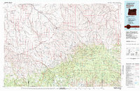
 1980 Monument1997 Print · USGSCentral Oregon’s river-cut high country comes into focus in the early 1980s, documenting a landscape of remote ranching and timber work. Genealogists and researchers can trace local landmarks like Ritter, the Cohoe Mine, and the high reaches of Sourdough Ridge.
 - 1981 Map of Heppner
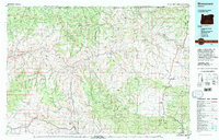
 1981 Heppner1981 Print · USGSNorth-Central Oregon's canyon country comes into focus in the early 1980s, centered on the high-desert plateaus and timbered slopes of Morrow County. Researchers can trace the Union Pacific rail corridor and find remote landmarks like Lonerock, Hardman, and the high peaks of the Umatilla National Forest.
 - 1981 Map of Condon, 1997 Print
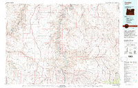 1981 Condon1997 Print · USGSNorth-central Oregon in the early eighties reveals a vast plateau landscape defined by the deep canyons of the John Day and Deschutes rivers. Researchers can trace the rural legacy of the region through small hubs like Condon, Fossil, and the Old Railroad Grade.2 unique versions available
 - 1984 Map of Hermiston
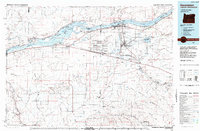 1984 Hermiston1984 Print · USGSThe Columbia River basin in the 1980s reveals a landscape of massive infrastructure, from hydroelectric dams to expansive military depots. Researchers can trace the industrial footprint of the Umatilla Ordnance Depot or locate historic rail hubs at Hinkle and Stanfield.2 unique versions available
End of results
Showing maps 1-5 of 5
Top cities of Morrow County
- Boardman historical maps
- Irrigon historical maps
- Heppner historical maps
- Ione historical maps
- Lexington historical maps
Frequently asked questions
- What are the different types of historical maps available for Morrow County?
- What is the oldest map of Morrow County?
- Where can I purchase historical maps of Morrow County for my home or office?
- Where can I download high-res historical maps of Morrow County?
- Are there historical topographic maps available for Morrow County?
- Is there historical aerial imagery available for Morrow County?
- Where are historical maps of Morrow County sourced from?