1930s Maps of Tillamook County, Oregon
Explore 3 historic maps of Tillamook County from the 1930s. These maps offer a rare glimpse into what life looked like during the 1930s — showing old roads, neighborhoods, homes, and landmarks that have changed or disappeared over time.
Whether you're researching your family's past, planning a metal detecting trip, or studying how Tillamook County's landscape evolved across the 1930s, these high-resolution maps are a powerful tool for exploring the history of this region.
- Focus on a specific era: All maps on this page are from the 1930s, giving you a focused view of this time period.
- See what’s changed: Compare century-old streets, trails, and buildings to today's modern landscape using overlays and satellite layers.
- Research with precision: Use these maps for genealogy, historical research, land use analysis, or educational projects.
- View, download, or print: Maps are fully viewable online in high resolution, and can be downloaded or printed for your own records.
Start exploring Tillamook County's history through authentic maps from the 1930s. This is your window into the past.
Tillamook County, OR maps
(3)- 1937 Map of Nehalem, 1954 Print
 1937 Nehalem1954 Print · USGSThe Tillamook coast in the late thirties shows a landscape of thriving seaside resorts and industrial rail lines. Genealogists and historians can trace the foundations of Bayocean and Garibaldi or locate the long-standing Nehalem Fish Hatchery and local mills.
 - 1937 Map of Enright, 1956 Print
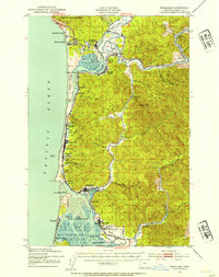
 1937 Enright1956 Print · USGSTillamook County's interior mountains are shown in the late 1930s, an era when the Southern Pacific railroad served as the lifeline for canyon settlements. Researchers can trace the old rail stops at Enright and Belfort or locate the Fish Hatchery near Lees Camp.
 - 1939 Map of Saddle Mountain, 1941 Print
 1939 Saddle Mountain1941 Print · USGSCoastal Oregon at the end of the 1930s is a landscape of dense timber and remote outposts. Genealogists and historians can trace the early road networks connecting Jewell and Elsie, or locate the C C C Camp Jewell and the Lewis and Clark GS deep in the hills.
End of results
Showing maps 1-3 of 3
Top cities of Tillamook County
- Tillamook historical maps
- Rockaway Beach historical maps
- Bay City historical maps
- Garibaldi historical maps
- Manzanita historical maps
- Wheeler historical maps
See more
Frequently asked questions
- What are the different types of historical maps available for Tillamook County?
- What is the oldest map of Tillamook County?
- Where can I purchase historical maps of Tillamook County for my home or office?
- Where can I download high-res historical maps of Tillamook County?
- Are there historical topographic maps available for Tillamook County?
- Is there historical aerial imagery available for Tillamook County?
- Where are historical maps of Tillamook County sourced from?