Old Maps of Tillamook County, Oregon for Genealogy
Trace your family roots with 263 historic maps of Tillamook County. These high-res maps reveal old neighborhoods, homesites, landmarks, and streets — helping you uncover where your ancestors lived and how the area evolved over time.
- Explore historic neighborhoods: Identify where your relatives may have lived in the 1800s or 1900s.
- Compare maps over time: Trace the changes in streets, buildings, and landmarks for multi-generational research.
- Perfect for genealogy & ancestry research: Used by family historians and researchers to map out lineage and migration.
These maps are an incredible resource for exploring your personal connection to Tillamook County's past.
Tillamook County, OR maps
(263)- 1937 Map of Nehalem, 1954 Print
 1937 Nehalem1954 Print · USGSThe Tillamook coast in the late thirties shows a landscape of thriving seaside resorts and industrial rail lines. Genealogists and historians can trace the foundations of Bayocean and Garibaldi or locate the long-standing Nehalem Fish Hatchery and local mills.
 - 1937 Map of Enright, 1956 Print
 1937 Enright1956 Print · USGSTillamook County's interior mountains are shown in the late 1930s, an era when the Southern Pacific railroad served as the lifeline for canyon settlements. Researchers can trace the old rail stops at Enright and Belfort or locate the Fish Hatchery near Lees Camp.
 - 1939 Map of Saddle Mountain, 1941 Print
 1939 Saddle Mountain1941 Print · USGSCoastal Oregon at the end of the 1930s is a landscape of dense timber and remote outposts. Genealogists and historians can trace the early road networks connecting Jewell and Elsie, or locate the C C C Camp Jewell and the Lewis and Clark GS deep in the hills.
 - 1940 Map of Cape Falcon
 1940 Cape Falcon1940 Print · USGSCoastal Clatsop County is captured just before the war, showing the development of Seaside and Cannon Beach along the Pacific. Researchers can trace early logging operations at the Markham Callow Logging Camp or locate the Ferndale Sch and Henderson Ranch.
 - 1941 Map of Keasey
 1941 Keasey1941 Print · USGSThe timber and rail economy of northwest Oregon is captured here just before the war. Trace the path of the Oregon American Lumber Co railroad and locate family landmarks like A W Nelsons Farm and the Winema Sch.
 - 1941 Map of Nestucca Bay
 1941 Nestucca Bay1941 Print · USGSThe Oregon coast at the start of the 1940s reveals a mix of timber industry and early seaside tourism. Trace the history of coastal work and recreation through labels like the Miles Lake CCC Camp, Hebo Alder Mill, and the many fire lookouts.
 - 1941 Map of Timber
 1941 Timber1941 Print · USGSCoastal Oregon at the start of the 1940s reveals a landscape defined by timber extraction and railroad expansion. Genealogists and historians can trace the remote logging life through Timber, Cochran, and numerous work sites like the Gonnacher Logging Camp.
 - 1941 Map of Enright
 1941 Enright1941 Print · USGSTimber and rail operations define the Tillamook backcountry in the early 1940s just after the Great Fire. Trace the Southern Pacific line past Enright and Belfort, or locate Lees Camp Ground and the Cedar Butte Lookout.
 - 1942 Map of Ginger Peak
 1942 Ginger Peak1942 Print · USGSCoastal Oregon mountain life is captured during the early 1940s as resource management and small-scale ranching shaped the forest drainages. Genealogists and researchers can locate Detrick Ranch, the Sturdevant Sch, and New Deal era labor sites like CCC Camp Trask.2 unique versions available
 - 1942 Map of Sheridan
 1942 Sheridan1942 Print · USGSThe South Yamhill River valley flourished in the early 1940s as a hub for timber and rail transport. Researchers can locate numerous vanished rural landmarks, including the Thompson Bros Lumber Mill, Wabash Sta, and many neighborhood schoolhouses like Red Prairie Sch.
 - 1942 Map of Spirit Mtn
 1942 Spirit Mtn1942 Print · USGSThe northern Oregon Coast Range and Grand Ronde Valley come into focus during the early years of the war. Researchers can trace the timber economy and tribal history through landmarks like the Grand Ronde Agency, Midway Lumber Co, and Cloverleaf Sch.
 - 1942 Map of Nestucca Bay
 1942 Nestucca Bay1942 Print · USGSCoastal Oregon is captured here during the early war years as timber and forest management shaped the local economy. Researchers can locate vanished infrastructure like the Hebohalder Mill and Powder House, or trace the development of Pacific City and Neskowin.
 - 1942 Map of Fairdale
 1942 Fairdale1942 Print · USGSThe Coast Range timber and water infrastructure are in full focus during the early years of the war. Researchers can locate the Fairdale C C C Camp, trace local education at the High Heaven Sch, and identify mountain landmarks like the Trask Mtn Lookout.
 - 1942 Map of Tillamook
 1942 Tillamook1942 Print · USGSCoastal Tillamook County is captured here in the early war years as a landscape of timbered hills and river deltas. You can trace the historic Southern Pacific rail line into Tillamook or locate vanished rural landmarks like Long Prairie Sch and Hemlock.2 unique versions available
 - 1943 Map of Nehalem
 1943 Nehalem1943 Print · USGSCoastal Tillamook County is captured here in the early 1940s, showing the early resort towns and timber-driven rail lines of the north Oregon shore. Genealogists and historians can trace the now-changed footprint of Bayocean or locate the Sawmill and Pine Grove Sch.
 - 1943 Map of Keasey
 1943 Keasey1943 Print · USGSThe timber country of the northern Oregon Coast Range comes alive in the early 1940s as loggers worked the Nehalem River basin. Researchers can trace the industrial footprint of the Oregon American Lumber Company and find small outposts like Birkenfeld, Keasey, and Neverstill.
 - 1943 Map of Saddle Mtn.
 1943 Saddle Mtn.1943 Print · USGSCoastal Oregon timberlands and the upper Nehalem River valley are captured in detail during the early forties. Researchers can trace the development of riverside settlements like Jewell and Tideport, or locate landmarks such as Vinemaple Sch and the Rector Lookout.
 - 1948 Map of Vancouver, 1957 Print
 1948 Vancouver1957 Print · USGSPost-war growth transforms the river valleys of the Pacific Northwest as the timber and rail economy thrives. Trace family roots in Tillamook or Oregon City, and locate vanished landmarks like the spit at Bayocean or the Skamania Mine.
 - 1950 Map of Vancouver
 1950 Vancouver1950 Print · USGSCoastal Oregon and the lower Columbia River valley are captured in detail just after the war. Researchers can trace historic rail routes like the Southern Pacific or locate early settlements such as Vernonia, Gaston, and the Grand Ronde Indian Reservation.
 - 1950 Map of Vancouver, 1951 Print
 1950 Vancouver1951 Print · USGSThe Pacific Northwest urban corridor meets the rugged coast in the years following the war, showing the expansion of Portland and Vancouver. Genealogists and historians can trace the reach of the Southern Pacific RR and locate coastal communities like Tillamook, Seaside, and Tolovana Park.
 - 1955 Map of Hebo, 1957 Print
 1955 Hebo1957 Print · USGSCoastal Tillamook County is captured here in the mid-fifties, showing the development of beach communities and forest management. Genealogists can trace family sites like Herbst Place or locate the Town Lake Cemetery and Cloverdale School.3 unique versions available
 - 1955 Map of Blaine, 1957 Print
 1955 Blaine1957 Print · USGSThe Oregon Coast Range near Blaine is shown in the mid-1950s as a landscape of timber management and forest retreats. Researchers can trace historic roads like the Old Toll Road and locate local landmarks such as the Nestucca Grange Hall and Detrick Ranch.2 unique versions available
 - 1955 Map of Saddle Mountain, 1957 Print
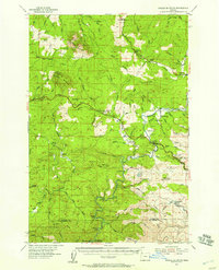 1955 Saddle Mountain1957 Print · USGSIn the mid-1950s, the timber-rich mountains of Clatsop County were defined by the Nehalem River and the expansion of the Sunset Highway. Genealogists and historians can trace old community centers like Jewell and Elsie, or locate the Logging Railroad near Salmonberry River.3 unique versions available
 - 1955 Map of Timber, 1957 Print
 1955 Timber1957 Print · USGSThe Oregon Coast Range in the mid-1950s was a hub of logging activity and rail transit through the mountains of Washington and Tillamook counties. Historians can trace the winding Southern Pacific rail line and locate forest outposts like Cochran and Timbuktu.2 unique versions available
 - 1955 Map of Fairdale, 1957 Print
 1955 Fairdale1957 Print · USGSThe Coast Range wilderness and logging frontier of the mid-fifties come into focus here at the intersection of Yamhill, Tillamook, and Washington Counties. Researchers can trace timber history and early outposts at Neverstill, Sixteenmile Cabin, and the High Heaven Lookout.3 unique versions available
Showing maps 1-25 of 263
Top cities of Tillamook County
- Tillamook historical maps
- Rockaway Beach historical maps
- Bay City historical maps
- Garibaldi historical maps
- Manzanita historical maps
- Wheeler historical maps
See more
Frequently asked questions
- What are the different types of historical maps available for Tillamook County?
- What is the oldest map of Tillamook County?
- Where can I purchase historical maps of Tillamook County for my home or office?
- Where can I download high-res historical maps of Tillamook County?
- Are there historical topographic maps available for Tillamook County?
- Is there historical aerial imagery available for Tillamook County?
- Where are historical maps of Tillamook County sourced from?