1980s Maps of Wallowa County, Oregon
Explore 6 historic maps of Wallowa County from the 1980s. These maps offer a rare glimpse into what life looked like during the 1980s — showing old roads, neighborhoods, homes, and landmarks that have changed or disappeared over time.
Whether you're researching your family's past, planning a metal detecting trip, or studying how Wallowa County's landscape evolved across the 1980s, these high-resolution maps are a powerful tool for exploring the history of this region.
- Focus on a specific era: All maps on this page are from the 1980s, giving you a focused view of this time period.
- See what’s changed: Compare century-old streets, trails, and buildings to today's modern landscape using overlays and satellite layers.
- Research with precision: Use these maps for genealogy, historical research, land use analysis, or educational projects.
- View, download, or print: Maps are fully viewable online in high resolution, and can be downloaded or printed for your own records.
Start exploring Wallowa County's history through authentic maps from the 1980s. This is your window into the past.
Wallowa County, OR maps
(6)- 1980 Map of Grangeville
 1980 Grangeville1980 Print · USGSGrangeville and the surrounding Camas Prairie are captured in the late twentieth century as the region balanced agriculture with its deep mining roots. Discover the locations of the Dewey Mine, the remote settlement of Florence, and the winding path of the Salmon River.
 - 1981 Map of Clarkston
 1981 Clarkston1981 Print · USGSNorthwestern river life and mountain terrain meet in the early eighties as the Snake River carves through the landscape. Researchers can trace rail history along the Camas Prairie Railroad and locate smaller settlements like Peola and Anatone.2 unique versions available
 - 1982 Map of Wallowa, 1983 Print
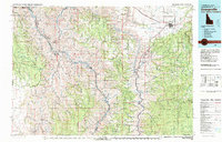
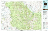
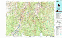
 1982 Wallowa1983 Print · USGSNortheast Oregon's rugged canyon country is captured here in the early eighties, showing a landscape defined by the Grande Ronde River and its high plateaus. Researchers can trace the Union Pacific line through Rondowa or locate vanished sites like Maxville and Palmer Junction.2 unique versions available
 - 1984 Map of Akers Butte, 1985 Print
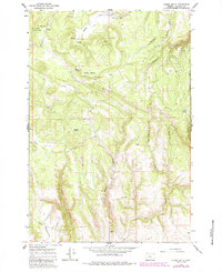 1984 Akers Butte1985 Print · USGSWallowa County's high ridges and deep canyons are recorded here during the early 1980s, reflecting a landscape shaped by timber and ranching. Genealogists and researchers can locate the settlement of Maxville, a remote Landing Strip, and named landmarks like Akers Butte.
 - 1986 Map of Enterprise, 1987 Print
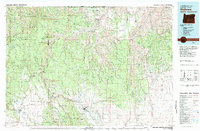
 1986 Enterprise1987 Print · USGSThe high peaks and deep valleys of Northeast Oregon are captured in the mid-1980s, showcasing the transition from the Grande Ronde Valley to the wilderness. Researchers can trace the Union Pacific rail corridor through Telocaset or locate historic sites like Cornucopia and Medical Springs.
 - 1987 Map of Riggins
 1987 Riggins1987 Print · USGSThe Salmon and Snake River canyons defined the Idaho-Oregon borderlands in the 1980s as wilderness recreation and historic mining sites overlapped. Researchers can trace the rugged access to Riggins, find high-altitude camps near Hazard Lake, and locate the Florence Mine or Black Bear Mine.
End of results
Showing maps 1-6 of 6
Top cities of Wallowa County
Frequently asked questions
- What are the different types of historical maps available for Wallowa County?
- What is the oldest map of Wallowa County?
- Where can I purchase historical maps of Wallowa County for my home or office?
- Where can I download high-res historical maps of Wallowa County?
- Are there historical topographic maps available for Wallowa County?
- Is there historical aerial imagery available for Wallowa County?
- Where are historical maps of Wallowa County sourced from?