1960s Maps of Centre County, Pennsylvania
Explore 34 historic maps of Centre County from the 1960s. These maps offer a rare glimpse into what life looked like during the 1960s — showing old roads, neighborhoods, homes, and landmarks that have changed or disappeared over time.
Whether you're researching your family's past, planning a metal detecting trip, or studying how Centre County's landscape evolved across the 1960s, these high-resolution maps are a powerful tool for exploring the history of this region.
- Focus on a specific era: All maps on this page are from the 1960s, giving you a focused view of this time period.
- See what’s changed: Compare century-old streets, trails, and buildings to today's modern landscape using overlays and satellite layers.
- Research with precision: Use these maps for genealogy, historical research, land use analysis, or educational projects.
- View, download, or print: Maps are fully viewable online in high resolution, and can be downloaded or printed for your own records.
Start exploring Centre County's history through authentic maps from the 1960s. This is your window into the past.
Centre County, PA maps
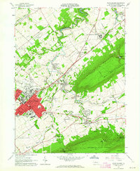
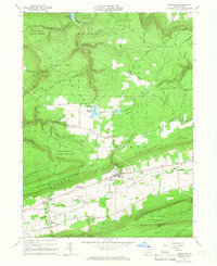
(34)- 1960 Map of Williamsport
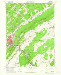
 1960 Williamsport1960 Print · USGSNorth-central Pennsylvania in the mid-twentieth century was a vital corridor of rail and river industry stretching from the New York line to the coal regions. Genealogists can trace the rail networks of the Pennsylvania RR and Lehigh Valley RR connecting towns like Williamsport, Towanda, and Lock Haven.
 - 1960 Map of Snow Shoe NW, 1962 Print
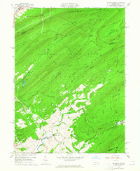
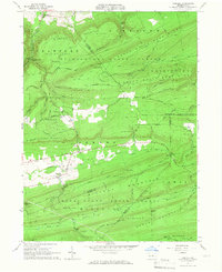
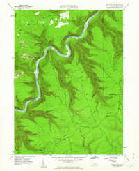 1960 Snow Shoe NW1962 Print · USGSThe West Branch of the Susquehanna winds through the high ridges of the Sproul State Forest at the start of the sixties. Genealogists and forest historians can trace the New York Central rail line, Nelson Cem, and the Panther Fire Tower.5 unique versions available
 - 1960 Map of Snow Shoe NE, 1962 Print
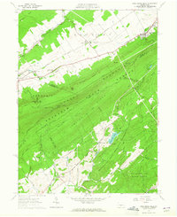
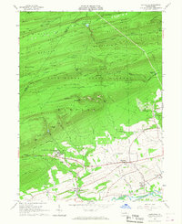
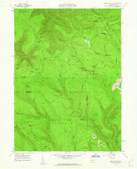 1960 Snow Shoe NE1962 Print · USGSThe Clinton and Centre County borderlands in the early sixties reveal a landscape of deep hollows and remote wilderness camps. Researchers can trace the heritage of local outdoor life at sites like Ralpton Camp, Wildcat Camp, and the Bald Hill Hunting Club.3 unique versions available
 - 1960 Map of Snow Shoe SE, 1962 Print
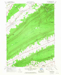
 1960 Snow Shoe SE1962 Print · USGSThe industrial and forest landscapes of central Pennsylvania are captured here at the start of the 1960s. Researchers can trace the path of the New York Central and Hudson River RR through the Hogback Tunnel or locate family roots at Summit Hill Cem and Orviston.4 unique versions available
 - 1960 Map of Snow Shoe, 1963 Print
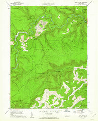
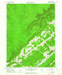
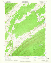
 1960 Snow Shoe1963 Print · USGSIn the early sixties, the coal-rich highlands of Centre County were defined by active extraction and small mountain settlements. Genealogists and historians can locate family cemeteries like St Marys Cem and trace the winding paths of the New York Central through Snow Shoe and Clarence.4 unique versions available
 - 1961 Map of Harrisburg
 1961 Harrisburg1961 Print · USGSCentral Pennsylvania is shown at a mid-century peak of industrial and military activity, from the Susquehanna water gaps to the fertile Dutch Country. Genealogists and historians can trace the rail corridors of the Pennsylvania RR and find landmarks like Carlisle Barracks or the Anthracite Coal Fields.2 unique versions available
 - 1962 Map of State College, 1964 Print
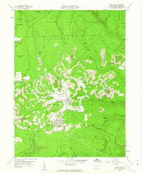
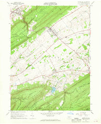
 1962 State College1964 Print · USGSState College and the Penn State campus are shown in the early sixties during a period of significant collegiate and local growth. Researchers can trace historic campus buildings like Old Main or locate outlying villages such as Boalsburg and Linden Hall.5 unique versions available
 - 1962 Map of Bellefonte, 1964 Print
 1962 Bellefonte1964 Print · USGSMid-century Centre County reveals a valley shaped by industry and civic institutions, from the bustling streets of Bellefonte to the ridges of Bald Eagle Mountain. Researchers can trace old family names at Fetzertown, locate the Trcziyulny Cem, or follow the Old Railroad Grade near Gum Stump.2 unique versions available
 - 1962 Map of Bear Knob, 1964 Print
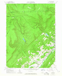
 1962 Bear Knob1964 Print · USGSCentre County's rugged ridge-and-valley landscape is documented here in the early sixties, showing the transition from mountain wilderness to valley settlements. Local historians can trace family sites at Unionville, Dicks Run Cem, and the Bush Hollow Ch.2 unique versions available
 - 1962 Map of Julian, 1965 Print
 1962 Julian1965 Print · USGSCentre County centers on the growth of State College and The Pennsylvania State University in the early sixties. Researchers can find old transportation routes like the Old Railroad Grade and local landmarks including Pine Hall and the State College Air Depot.5 unique versions available
 - 1962 Map of Williamsport, 1966 Print
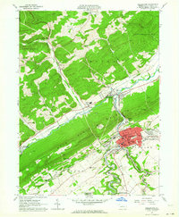
 1962 Williamsport1966 Print · USGSNorth-central Pennsylvania was a landscape of industrial river hubs and vast state woodlands in the early sixties. Researchers can trace the path of the Pennsylvania Railroad through Williamsport and explore the remote reaches of Bucktail State Park.5 unique versions available
 - 1963 Map of Tipton, 1965 Print
 1963 Tipton1965 Print · USGSThe Little Juniata River valley near Tyrone was a bustling transit corridor in the early 1960s. Researchers can trace the Pennsylvania railroad line through Grazierville and Tipton, or locate historic sites like the Fox Cem and a Covered Bridge.3 unique versions available
 - 1963 Map of Mc Alevys Fort, 1965 Print
 1963 Mc Alevys Fort1965 Print · USGSNorth of Huntingdon in the mid-1960s, this area shows a landscape defined by prominent ridges and early industrial sites. Researchers can trace local genealogy at McAlevys Fort or find historic locations like the Jackson-Miller Sch and Greenwood Furnace.4 unique versions available
 - 1963 Map of Tyrone, 1965 Print
 1963 Tyrone1965 Print · USGSIn the early 1960s, the industrial corridor along the Little Juniata River was a hub of transit and production. Trace the rail lines and old roads through Tyrone, Warriors Mark, and Birmingham, or locate family landmarks like Baughman Cem and Grier Sch.4 unique versions available
 - 1963 Map of Franklinville, 1965 Print
 1963 Franklinville1965 Print · USGSCentral Pennsylvania’s industrial and agricultural valleys are captured here in the early sixties. Researchers can trace the heritage of Pennsylvania Furnace and locate landmark sites like Indian Caverns and Warriors Mark Airport.3 unique versions available
 - 1963 Map of Pine Grove Mills, 1965 Print
 1963 Pine Grove Mills1965 Print · USGSThe ridges of central Pennsylvania define this early 1960s landscape, where university experimental forests meet historic furnace settlements. Genealogists and researchers can trace the valley communities of Pine Grove Mills and Neffs Mills or locate local landmarks like the Pennsylvania Furnace Cem and Monroe Furnace.4 unique versions available
 - 1964 Map of Pittsburgh
 1964 Pittsburgh1964 Print · USGSWestern Pennsylvania in the late fifties and early sixties shows a landscape of powerful river industries and expanding highways. Genealogists and historians can trace the rail corridors of the Pennsylvania RR through industrial hubs like Johnstown, Altoona, and Nanty Glo.
 - 1964 Map of Harrisburg
 1964 Harrisburg1964 Print · USGSCentral Pennsylvania in the mid-fifties reveals a landscape shaped by ridge-and-valley geology and critical Cold War infrastructure. Researchers can trace the massive Indiantown Gap Military Reservation or the rail corridors of the Pennsylvania RR and Reading RR.
 - 1965 Map of Williamsport
 1965 Williamsport1965 Print · USGSNorth-central Pennsylvania in the mid-1960s is defined by the industrial river towns and vast timberlands of the Allegheny Plateau. Researchers can trace historic rail lines like the Erie Lackawanna and Reading as they thread through Williamsport, Lock Haven, and Jersey Shore.
 - 1965 Map of Loganton, 1966 Print
 1965 Loganton1966 Print · USGSCentral Pennsylvania's isolated Sugar Valley is seen here in the mid-1960s, showing a string of agricultural hamlets between forested ridges. Genealogists can locate family sites at Booneville, Greenburr, and the Old Schracktown Cem.3 unique versions available
 - 1965 Map of Carroll, 1967 Print
 1965 Carroll1967 Print · USGSCentral Pennsylvania's ridge-and-valley terrain is captured here in the mid-1960s, showing the isolated communities of Carroll and Eastville. Researchers can locate family sites at the Sugar Valley Ch Cem or trace the old paths through McMurrin Gap and past the Mt Union Ch.4 unique versions available
 - 1965 Map of Hartleton, 1967 Print
 1965 Hartleton1967 Print · USGSThe heart of Union County in the mid-sixties reveals a landscape where state forests and small valley settlements meet. Researchers can find precise locations for the Laurelton State Village, the Western Area Sch, and a Covered Bridge crossing Penns Creek.2 unique versions available
 - 1966 Map of Williamsport
 1966 Williamsport1966 Print · USGSThe Susquehanna Valley was a hub of transit and industry in the mid-seventies, where the river's West Branch connected major college towns and timberlands. Researchers can trace historical rail lines like the Reading or locate regional landmarks from Jersey Shore to Ricketts Glen State Park.
 - 1966 Map of Madisonburg, 1968 Print
 1966 Madisonburg1968 Print · USGSCentre County at the height of the mid-sixties reveals a landscape of high ridges and agricultural valleys. Genealogists and historians can trace family locations near Madisonburg, the site of Penns Cave, and rural landmarks like St Marks Cem Ch.4 unique versions available
 - 1966 Map of Centre Hall, 1968 Print
 1966 Centre Hall1968 Print · USGSPenn Valley and the surrounding ridges of central Pennsylvania are captured here in the mid-1960s, a period of established university research and state forest conservation. Researchers can trace the railroad corridor of the Penn Central or locate family sites near Tusseyville, Potters Mills, and the Egg Hill Cem.3 unique versions available
Showing maps 1-25 of 34
Top cities of Centre County
- State College historical maps
- Bellefonte historical maps
- Philipsburg historical maps
- Milesburg historical maps
- Centre Hall historical maps
- Snow Shoe historical maps
See more
Frequently asked questions
- What are the different types of historical maps available for Centre County?
- What is the oldest map of Centre County?
- Where can I purchase historical maps of Centre County for my home or office?
- Where can I download high-res historical maps of Centre County?
- Are there historical topographic maps available for Centre County?
- Is there historical aerial imagery available for Centre County?
- Where are historical maps of Centre County sourced from?