1930s Maps of Centre County, Pennsylvania
Explore 8 historic maps of Centre County from the 1930s. These maps offer a rare glimpse into what life looked like during the 1930s — showing old roads, neighborhoods, homes, and landmarks that have changed or disappeared over time.
Whether you're researching your family's past, planning a metal detecting trip, or studying how Centre County's landscape evolved across the 1930s, these high-resolution maps are a powerful tool for exploring the history of this region.
- Focus on a specific era: All maps on this page are from the 1930s, giving you a focused view of this time period.
- See what’s changed: Compare century-old streets, trails, and buildings to today's modern landscape using overlays and satellite layers.
- Research with precision: Use these maps for genealogy, historical research, land use analysis, or educational projects.
- View, download, or print: Maps are fully viewable online in high resolution, and can be downloaded or printed for your own records.
Start exploring Centre County's history through authentic maps from the 1930s. This is your window into the past.
Centre County, PA maps
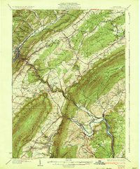
(8)- 1931 Map of Show Shoe
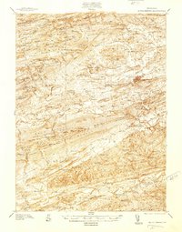
 1931 Show Shoe1931 Print · USGSThe Pennsylvania coalfields and river valleys are captured here in the early 1930s, showing a rugged landscape defined by mountain camps and mining towns. Genealogists can trace family roots through industrial settlements like Clarence and Snow Shoe or locate old schools such as Cherry Run Sch.3 unique versions available
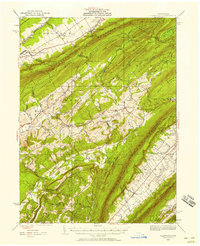
 - 1932 Map of Karthaus
 1932 Karthaus1932 Print · USGSThe Susquehanna’s West Branch winds through Clearfield and Centre Counties in the late 1920s, a landscape shaped by the rail and timber industries. Genealogists can trace family names through dozens of rural schools and churches like Mignot Sch and Fairview Ch.3 unique versions available
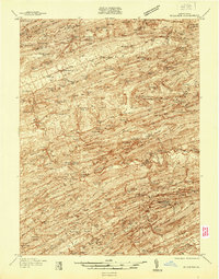
 - 1933 Map of Tyrone
 1933 Tyrone1933 Print · USGSCentral Pennsylvania's iron and rail heritage is on full display here in the early thirties as the industrial hub of Tyrone connects the valleys. Genealogists can trace family footprints at Pennsylvania Furnace, Grazier Mill, and dozens of rural schoolhouses like Rural Choice Sch.3 unique versions available
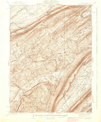
 - 1935 Map of Allensville, 1958 Print
 1935 Allensville1958 Print · USGSThe ridge-and-valley country of central Pennsylvania is captured here in the mid-1930s as the local economy shifted toward conservation and forestry. Researchers can find traditional crossroads like McAlevys Fort, local landmarks such as Compropst Mill, and depression-era Owl Gap CCC Camp sites.2 unique versions available
 - 1937 Map of Millheim
 1937 Millheim1937 Print · USGSThe Seven Mountains region of central Pennsylvania is shown here in the late thirties, when rural valleys were tied together by narrow gaps. Researchers can locate family landmarks like Wolfs Chapel, Lose Sch, and vanished stopovers such as Wolfs Store.
 - 1938 Map of Allensville
 1938 Allensville1938 Print · USGSCentral Pennsylvania's valleys and ridges were a hive of rural industry and New Deal activity in the mid-1930s. Researchers can locate vanished schoolhouses and industrial sites like Greenwood Furnace, Cornpropst Mill, and the Mount Gap CCC Camp.3 unique versions available
 - 1938 Map of Mifflinburg
 1938 Mifflinburg1938 Print · USGSCentral Pennsylvania valleys and ridges are captured here in the late thirties, showing the rural networks of Union and Snyder counties. Genealogists can trace family roots through numerous local schools like Gilbert Sch and settlements such as Troxelville or White Springs.
 - 1939 Map of Philipsburg, 1955 Print
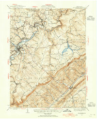 1939 Philipsburg1955 Print · USGSCentral Pennsylvania’s coal and iron country is captured here during the late thirties, showing the rail-linked settlements of the Moshannon Valley. Researchers can trace family roots at Black Oak Sch, find old industrial sites like Martha Furnace, or locate the Rusnak Mine.2 unique versions available
End of results
Showing maps 1-8 of 8
Top cities of Centre County
- State College historical maps
- Bellefonte historical maps
- Philipsburg historical maps
- Milesburg historical maps
- Centre Hall historical maps
- Snow Shoe historical maps
See more
Frequently asked questions
- What are the different types of historical maps available for Centre County?
- What is the oldest map of Centre County?
- Where can I purchase historical maps of Centre County for my home or office?
- Where can I download high-res historical maps of Centre County?
- Are there historical topographic maps available for Centre County?
- Is there historical aerial imagery available for Centre County?
- Where are historical maps of Centre County sourced from?