Old Maps of Centre County, Pennsylvania for Genealogy
Trace your family roots with 316 historic maps of Centre County. These high-res maps reveal old neighborhoods, homesites, landmarks, and streets — helping you uncover where your ancestors lived and how the area evolved over time.
- Explore historic neighborhoods: Identify where your relatives may have lived in the 1800s or 1900s.
- Compare maps over time: Trace the changes in streets, buildings, and landmarks for multi-generational research.
- Perfect for genealogy & ancestry research: Used by family historians and researchers to map out lineage and migration.
These maps are an incredible resource for exploring your personal connection to Centre County's past.
Centre County, PA maps
(316)- 1903 Map of Houtzdale, 1959 Print
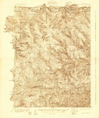
 1903 Houtzdale1959 Print · USGSClearfield County was a hub of rail and river activity at the turn of the century as industrial towns expanded along the Allegheny Mts. Researchers can trace the early layout of Houtzdale, find family-named post offices like Oshanter P.O. Mitchells, and follow the winding Clearfield Creek.
 - 1905 Map of Houtzdale
 1905 Houtzdale1905 Print · USGSHoutzdale and the surrounding Clearfield County coalfields are captured here during their industrial prime at the turn of the century. Genealogists and historians can trace rail-dependent settlements and local post offices like Kephart P.O., Belsena Mills, and Brisbin.5 unique versions available
 - 1908 Map of Bellefonte, 1956 Print
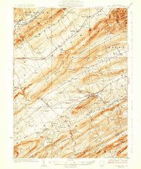
 1908 Bellefonte1956 Print · USGSCentre County at the opening of the twentieth century is a landscape of thriving rail hubs and early academic growth. Genealogists and local historians can trace the foundations of Pennsylvania State College and locate vanished rural landmarks like the Silverdale School or Scotia Benore PO.3 unique versions available
 - 1909 Map of Bellefonte
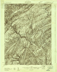
 1909 Bellefonte1909 Print · USGSCentre County at the turn of the century shows a burgeoning academic and industrial landscape centered on the early campus of Pennsylvania State College. Genealogists can trace family names through rural landmarks like Scotia Benore PO, Fairview Church, and the Silverdale School.7 unique versions available
 - 1919 Map of Menno
 1919 Menno1919 Print · USGSHuntingdon County is shown at the end of the first World War, when small-town industry and rail travel still dictated the local rhythm. Genealogists and historians can locate family-named landmarks like McAlevys Fort, Cornpropst Mills, and the Union Church near the county line.
 - 1920 Map of Altoona, 1954 Print
 1920 Altoona1954 Print · USGSThe industrial and rail-heavy corridor of the 1920s is on full display as the Pennsylvania RR cuts through the mountains. Genealogists and local historians can trace family roots through numerous country schools like Beech Grove School and lost settlements such as Wopsononock or Fostoria.6 unique versions available
 - 1921 Map of Howard
 1921 Howard1921 Print · USGSThe valleys and ridges of Central Pennsylvania are captured here just as the rail-and-river economy was maturing. Researchers can trace family sites among a high density of rural schools and churches like Cedar Spring School, Hunter Run Church, and the town of Lamar.3 unique versions available
 - 1921 Map of Williamsport
 1921 Williamsport1921 Print · USGSWilliamsport and the West Branch Susquehanna valley are captured here in the early 1920s, showing a landscape defined by rail corridors and steep mountain ridges. Genealogists can locate family-named schools and social landmarks like the Morgan Valley School, Nippono Park, and Shakespeare Club.
 - 1921 Map of Lock Haven, 1958 Print
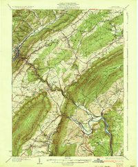
 1921 Lock Haven1958 Print · USGSLock Haven and the Susquehanna River West Branch are captured in the early twenties, showing a landscape defined by industry and mountain ridges. Researchers can trace historic schools and family hamlets from Woolrich to Logan Mills, or locate the State Normal School and Great Island.2 unique versions available
 - 1922 Map of Philipsburg
 1922 Philipsburg1922 Print · USGSPhilipsburg and the northern Allegheny coalfields are captured here in the early twenties during a period of heavy rail and mining activity. Genealogists can trace family locations through dozens of named rural schoolhouses like Klondike School and industrial sites including Cuba Mines and the Central RR of Pennsylvania.3 unique versions available
 - 1922 Map of Altoona
 1922 Altoona1922 Print · USGSThe industrial hub of Altoona and the steep slopes of the Allegheny Front are captured here in the early 1920s. Researchers can trace the extensive rail operations of the Pennsylvania railroad and locate numerous vanished rural landmarks like the Richland School and Grandview Cemetery.8 unique versions available
 - 1923 Map of Howard
 1923 Howard1923 Print · USGSThe valleys of Clinton and Center counties were bustling with rural life in the 1920s as the rail and river economy matured. Genealogists can locate over a dozen local schoolhouses like Wagner School and trace the paths of the Pennsylvania Railroad and Beech Creek Sta.6 unique versions available
 - 1923 Map of Lock Haven
 1923 Lock Haven1923 Print · USGSThe West Branch Susquehanna River corridor in the early twenties reveals a landscape of industrial river towns and isolated mountain valleys. Genealogists can locate family landmarks like the Swissdale School, Liberty Church, and the grounds of the State Normal School.7 unique versions available
 - 1923 Map of Williamsport
 1923 Williamsport1923 Print · USGSWilliamsport and the Susquehanna riverfront are captured here in the early twenties, showing a region defined by industrial rail lines and steep ridges. You can trace the path of the Pennsylvania Canal (Abandoned) or locate rural landmarks like Nippono Park and the Captain Greene Monument.6 unique versions available
 - 1923 Map of Tyrone
 1923 Tyrone1923 Print · USGSThe industrial and rail corridor of the Juniata Valley is captured here in the early twenties as it winds between massive ridges. Researchers can locate early iron landmarks like Huntingdon Furnace, local schools such as Kinch School, and the rail junction at Tyrone.4 unique versions available
 - 1924 Map of Centre Hall, 1958 Print
 1924 Centre Hall1958 Print · USGSCentral Pennsylvania's ridge-and-valley landscape is captured here in the 1920s, showing a world of limestone springs and mountain gaps. Genealogists can locate family homesteads near Old Fort, Tusseyville, and dozens of rural schoolhouses like Gentzel School.2 unique versions available
 - 1924 Map of Lewistown, 1958 Print
 1924 Lewistown1958 Print · USGSMifflin County settlements line the river and valley floor during the mid-1920s, showing the region's transition from agrarian mills to industrial rail hubs. Researchers can locate vanished rural landmarks such as Union Mills, Emma Chapel, and numerous family-named sites like Strodes Mills.2 unique versions available
 - 1927 Map of Lewisburg
 1927 Lewisburg1927 Print · USGSThe central Pennsylvania landscape in the 1920s is defined here by the winding Juniata River and the industrial hubs of Lewistown and Burnham. Local historians can trace old river crossings like Lafolds Ford or the many rural schoolhouses like Yoder School and Brice School.5 unique versions available
 - 1928 Map of Snow Shoe
 1928 Snow Shoe1928 Print · USGSCentre County's coal and timber country is documented here in the late 1920s, showing the intersection of heavy industry and wilderness. Researchers can locate active operations like Mine No 25, the village of Gillintown, and the remote Soldiers Home Camp.5 unique versions available
 - 1929 Map of Centre Hall
 1929 Centre Hall1929 Print · USGSCentral Pennsylvania's ridge-and-valley country is shown here in the late 1920s as a landscape of rural schools and water mills. Genealogists can trace family footprints at Old Fort, Penn Cave, and dozens of school sites like Gentzel School.4 unique versions available
 - 1929 Map of Tyrone
 1929 Tyrone1929 Print · USGSCentral Pennsylvania during the 1920s reveals a landscape defined by industrial rail towns and limestone valleys. Trace the route of the Pennsylvania Railroad past historic sites like Graziers Mill and Union Furnace.6 unique versions available
 - 1929 Map of Karthaus
 1929 Karthaus1929 Print · USGSThe West Branch Susquehanna River and its steep hollows defined life in Clearfield County during the late twenties. Researchers can trace the riverfront New York Central Railroad and find dozens of rural school sites like Fairview Sch and the community at Frenchville.3 unique versions available
 - 1931 Map of Show Shoe
 1931 Show Shoe1931 Print · USGSThe Pennsylvania coalfields and river valleys are captured here in the early 1930s, showing a rugged landscape defined by mountain camps and mining towns. Genealogists can trace family roots through industrial settlements like Clarence and Snow Shoe or locate old schools such as Cherry Run Sch.3 unique versions available
 - 1932 Map of Karthaus
 1932 Karthaus1932 Print · USGSThe Susquehanna’s West Branch winds through Clearfield and Centre Counties in the late 1920s, a landscape shaped by the rail and timber industries. Genealogists can trace family names through dozens of rural schools and churches like Mignot Sch and Fairview Ch.3 unique versions available
 - 1933 Map of Tyrone
 1933 Tyrone1933 Print · USGSCentral Pennsylvania's iron and rail heritage is on full display here in the early thirties as the industrial hub of Tyrone connects the valleys. Genealogists can trace family footprints at Pennsylvania Furnace, Grazier Mill, and dozens of rural schoolhouses like Rural Choice Sch.3 unique versions available
Showing maps 1-25 of 316
Top cities of Centre County
- State College historical maps
- Bellefonte historical maps
- Philipsburg historical maps
- Milesburg historical maps
- Centre Hall historical maps
- Snow Shoe historical maps
See more
Frequently asked questions
- What are the different types of historical maps available for Centre County?
- What is the oldest map of Centre County?
- Where can I purchase historical maps of Centre County for my home or office?
- Where can I download high-res historical maps of Centre County?
- Are there historical topographic maps available for Centre County?
- Is there historical aerial imagery available for Centre County?
- Where are historical maps of Centre County sourced from?