1940s Maps of Centre County, Pennsylvania
Explore 14 historic maps of Centre County from the 1940s. These maps offer a rare glimpse into what life looked like during the 1940s — showing old roads, neighborhoods, homes, and landmarks that have changed or disappeared over time.
Whether you're researching your family's past, planning a metal detecting trip, or studying how Centre County's landscape evolved across the 1940s, these high-resolution maps are a powerful tool for exploring the history of this region.
- Focus on a specific era: All maps on this page are from the 1940s, giving you a focused view of this time period.
- See what’s changed: Compare century-old streets, trails, and buildings to today's modern landscape using overlays and satellite layers.
- Research with precision: Use these maps for genealogy, historical research, land use analysis, or educational projects.
- View, download, or print: Maps are fully viewable online in high resolution, and can be downloaded or printed for your own records.
Start exploring Centre County's history through authentic maps from the 1940s. This is your window into the past.
Centre County, PA maps
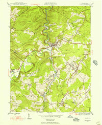
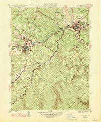
(14)- 1941 Map of Millheim
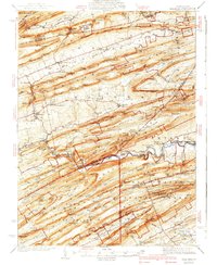 1941 Millheim1941 Print · USGSCentral Pennsylvania's ridge-and-valley landscape is documented here just before the mid-century, showing a network of mountain gaps and small valley settlements. Researchers can locate family landmarks like Wolfs Chapel, the Hironimus Sch, and the BM Sawmill along the banks of Penns Creek.3 unique versions available
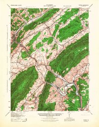
 - 1943 Map of Lewistown
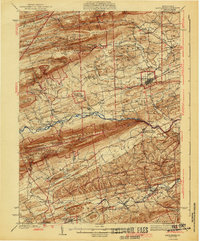
 1943 Lewistown1943 Print · USGSCentral Pennsylvania's rugged ridge-and-valley landscape is documented here during the mid-forties, showing the deep integration of rail lines and mountain gaps. Genealogists can trace family footprints through numerous rural landmarks like Emma Chapel, Mattern Junction, and the McNitt School.
 - 1943 Map of Mifflinburg
 1943 Mifflinburg1943 Print · USGSUnion and Snyder County communities are captured here in the years preceding World War II, revealing a landscape of ridge-top forests and valley farms. Genealogists can trace family roots through numerous country landmarks like Moyers Mill, Church of the Brethren, and the Lewis Cemetery.
 - 1944 Map of Williamsport
 1944 Williamsport1944 Print · USGSThe West Branch Susquehanna River valley was a bustling corridor of industry and agriculture during the mid-forties. Researchers can trace the Pennsylvania RR through Linden Station or find rural schools like Riedy School and the Captain Greene Monument.
 - 1944 Map of Lock Haven
 1944 Lock Haven1944 Print · USGSClinton County during the mid-forties shows a landscape defined by the river-and-rail economy and its transition to early aviation. Genealogists can trace family names at rural sites like Gravel Hill School, Fairpoint Church, and the industrial village of Woolrich.
 - 1944 Map of Houtzdale, 1956 Print
 1944 Houtzdale1956 Print · USGSClearfield County and the western edge of the Allegheny Mountains are shown here during the mid-1940s, as the region's mining and rail network remained in full operation. Genealogists can trace family roots in industrial villages like Houtzdale, Morann, and Brisbin, or locate rural landmarks like Ocean Sch and the Osceola Mills P O and Sta.5 unique versions available
 - 1945 Map of Philipsburg
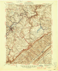 1945 Philipsburg1945 Print · USGSPhilipsburg and the central Pennsylvania coal country are shown here in the mid-1940s as industry and recreation shaped the landscape. Researchers can trace the legacy of the NEW YORK CENTRAL railroad, find the site of Martha Furnace, or locate rural schools like Hope Sch and Black Oak Sch.
 - 1945 Map of Ramey, 1955 Print
 1945 Ramey1955 Print · USGSClearfield County's coal and rail corridors are captured here just as the post-war era began. Researchers can trace family roots and vanished landmarks through Madera, the Manor Hill Sch, and the Janesville Smithmill P O.4 unique versions available
 - 1946 Map of Tyrone
 1946 Tyrone1946 Print · USGSThe valleys of Blair and Huntingdon counties are captured here in the 1940s as rail and river corridors defined local life. Researchers can trace the Pennsylvania Canal, find family-named schoolhouses like Eyer Sch, or locate the historic Huntingdon Furnace.
 - 1946 Map of Renovo West, 1953 Print
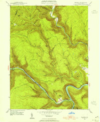
 1946 Renovo West1953 Print · USGSClinton County's river valleys and ridgelines come alive in this mid-century survey of the Pennsylvania wilds. Trace the industrial footprint of the Pennsylvania RR through Renovo or find family history at Laurel Hill Cem and Summerson Cem.9 unique versions available
 - 1946 Map of Keating, 1954 Print
 1946 Keating1954 Print · USGSClinton County’s deep river valleys and high ridges are shown just after the war, centered on the strategic rail junction at Keating. Genealogists and industrial historians can trace the New York Central line through the mountains and locate the settlement at Bitumen.4 unique versions available
 - 1947 Map of Ramey
 1947 Ramey1947 Print · USGSPost-war Clearfield County is captured here during a peak era of rail-driven mountain industry and rural settlement. Genealogists can trace family names at Hegarty Crossroads, find the Janesville Smithmill P O, or locate ancestors at Calvary Cem.2 unique versions available
 - 1947 Map of Houtzdale
 1947 Houtzdale1947 Print · USGSClearfield and Centre counties appear here during the late 1940s, showing the height of the mountain coal and rail era. Genealogists can trace family roots through coal-patch towns like Houtzdale and Brisbin or find small landmarks like Ocean School and the Osceola Reservoir.
 - 1948 Map of Keating
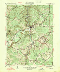
 1948 Keating1948 Print · USGSThe confluence of the Susquehanna and Sinnemahoning Creek appears in the late 1940s as a vital railroad corridor through the mountains. Genealogists and historians can trace the riverside rail stops at Keating and Wistar or the upland community of Bitumen.
End of results
Showing maps 1-14 of 14
Top cities of Centre County
- State College historical maps
- Bellefonte historical maps
- Philipsburg historical maps
- Milesburg historical maps
- Centre Hall historical maps
- Snow Shoe historical maps
See more
Frequently asked questions
- What are the different types of historical maps available for Centre County?
- What is the oldest map of Centre County?
- Where can I purchase historical maps of Centre County for my home or office?
- Where can I download high-res historical maps of Centre County?
- Are there historical topographic maps available for Centre County?
- Is there historical aerial imagery available for Centre County?
- Where are historical maps of Centre County sourced from?