1940s Maps of Rush Township, Pennsylvania
Explore 6 historic maps of Rush Township from the 1940s. These maps offer a rare glimpse into what life looked like during the 1940s — showing old roads, neighborhoods, homes, and landmarks that have changed or disappeared over time.
Whether you're researching your family's past, planning a metal detecting trip, or studying how Rush Township's landscape evolved across the 1940s, these high-resolution maps are a powerful tool for exploring the history of this region.
- Focus on a specific era: All maps on this page are from the 1940s, giving you a focused view of this time period.
- See what’s changed: Compare century-old streets, trails, and buildings to today's modern landscape using overlays and satellite layers.
- Research with precision: Use these maps for genealogy, historical research, land use analysis, or educational projects.
- View, download, or print: Maps are fully viewable online in high resolution, and can be downloaded or printed for your own records.
Start exploring Rush Township's history through authentic maps from the 1940s. This is your window into the past.
Rush Township, PA maps
(6)- 1943 Map of Lewistown
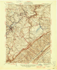
 1943 Lewistown1943 Print · USGSCentral Pennsylvania's rugged ridge-and-valley landscape is documented here during the mid-forties, showing the deep integration of rail lines and mountain gaps. Genealogists can trace family footprints through numerous rural landmarks like Emma Chapel, Mattern Junction, and the McNitt School.
 - 1944 Map of Houtzdale, 1956 Print
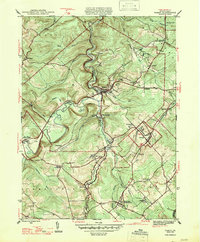
 1944 Houtzdale1956 Print · USGSClearfield County and the western edge of the Allegheny Mountains are shown here during the mid-1940s, as the region's mining and rail network remained in full operation. Genealogists can trace family roots in industrial villages like Houtzdale, Morann, and Brisbin, or locate rural landmarks like Ocean Sch and the Osceola Mills P O and Sta.5 unique versions available
 - 1945 Map of Philipsburg
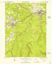
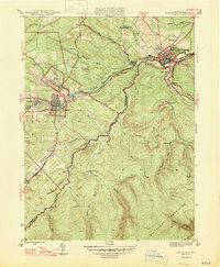
 1945 Philipsburg1945 Print · USGSPhilipsburg and the central Pennsylvania coal country are shown here in the mid-1940s as industry and recreation shaped the landscape. Researchers can trace the legacy of the NEW YORK CENTRAL railroad, find the site of Martha Furnace, or locate rural schools like Hope Sch and Black Oak Sch.
 - 1945 Map of Ramey, 1955 Print
 1945 Ramey1955 Print · USGSClearfield County's coal and rail corridors are captured here just as the post-war era began. Researchers can trace family roots and vanished landmarks through Madera, the Manor Hill Sch, and the Janesville Smithmill P O.4 unique versions available
 - 1947 Map of Ramey
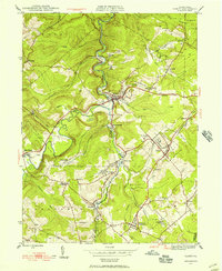
 1947 Ramey1947 Print · USGSPost-war Clearfield County is captured here during a peak era of rail-driven mountain industry and rural settlement. Genealogists can trace family names at Hegarty Crossroads, find the Janesville Smithmill P O, or locate ancestors at Calvary Cem.2 unique versions available
 - 1947 Map of Houtzdale
 1947 Houtzdale1947 Print · USGSClearfield and Centre counties appear here during the late 1940s, showing the height of the mountain coal and rail era. Genealogists can trace family roots through coal-patch towns like Houtzdale and Brisbin or find small landmarks like Ocean School and the Osceola Reservoir.
End of results
Showing maps 1-6 of 6
Top cities near Rush Township
- Tyrone historical maps
- Philipsburg historical maps
- Warriors Mark Township historical maps
- Graham historical maps
- Bigler historical maps
- Osceola Mills historical maps
See more
Top neighborhoods of Rush Township
- Glass City historical maps
- Earnestville historical maps
- North Philipsburg historical maps
- New Town historical maps
- Casanova historical maps
- Spike Island historical maps
See more
Frequently asked questions
- What are the different types of historical maps available for Rush Township?
- What is the oldest map of Rush Township?
- Where can I purchase historical maps of Rush Township for my home or office?
- Where can I download high-res historical maps of Rush Township?
- Are there historical topographic maps available for Rush Township?
- Is there historical aerial imagery available for Rush Township?
- Where are historical maps of Rush Township sourced from?