1990s Maps of Rush Township, Pennsylvania
Explore 7 historic maps of Rush Township from the 1990s. These maps offer a rare glimpse into what life looked like during the 1990s — showing old roads, neighborhoods, homes, and landmarks that have changed or disappeared over time.
Whether you're researching your family's past, planning a metal detecting trip, or studying how Rush Township's landscape evolved across the 1990s, these high-resolution maps are a powerful tool for exploring the history of this region.
- Focus on a specific era: All maps on this page are from the 1990s, giving you a focused view of this time period.
- See what’s changed: Compare century-old streets, trails, and buildings to today's modern landscape using overlays and satellite layers.
- Research with precision: Use these maps for genealogy, historical research, land use analysis, or educational projects.
- View, download, or print: Maps are fully viewable online in high resolution, and can be downloaded or printed for your own records.
Start exploring Rush Township's history through authentic maps from the 1990s. This is your window into the past.
Rush Township, PA maps
(7)- 1993 Map of Houtzdale, 1994 Print
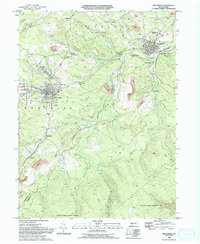 1993 Houtzdale1994 Print · USGSThe coal and rail corridors of Clearfield County are shown in great detail during the early nineties, centered on the historic borough of Houtzdale. Researchers can trace the layout of traditional mining settlements like Osceola Mills and Earnestville or locate family sites at St Joseph Cem.2 unique versions available
 - 1993 Map of Ramey, 1994 Print
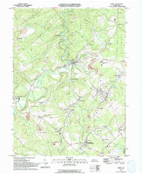 1993 Ramey1994 Print · USGSClearfield County's coal country is captured here in the early nineties, showing a landscape defined by industry and valley hamlets. Researchers can trace family roots at Janesville, Hegarty Crossroads, and the St Marys Cem.
 - 1994 Map of Sandy Ridge, 1997 Print
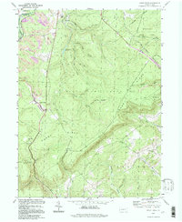 1994 Sandy Ridge1997 Print · USGSSandy Ridge and the surrounding forest lands are captured in the late twentieth century as the industrial landscape of the Alleghenies evolved. Local historians can trace old transportation routes via the CONRAIL lines and find family landmarks like Mt Pleasant Cem and the small settlement of Glass City.
 - 1994 Map of Port Matilda, 1997 Print
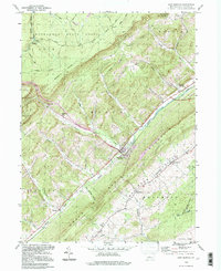 1994 Port Matilda1997 Print · USGSPort Matilda and the Bald Eagle Valley are shown here in the mid-1990s, capturing the interface between deep state forests and valley settlements. Researchers can trace family sites at Martha Furnace, Stormstown, and the Brown Cem near the mountain ridge.
 - 1994 Map of Black Moshannon, 1997 Print
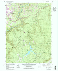 1994 Black Moshannon1997 Print · USGSCentre and Clearfield Counties in the 1990s show a landscape of high-plateau wilderness preserved alongside active coal mining operations. Researchers can trace historical forest management at the Rattlesnake Lookout Tower or locate the village sites of Grassflat and Peale.
 - 1994 Map of Philipsburg, 1997 Print
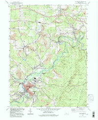 1994 Philipsburg1997 Print · USGSIn the mid-nineties, the coal country of the Allegheny Plateau reveals a landscape shaped by decades of mining and the winding path of Moshannon Creek. Genealogists and historians can trace family ties through Kylertown Cem, locate old industrial sites like the Kilns, or follow the old RR grade near Morrisdale.
 - 1998 Map of Bear Knob, 1999 Print
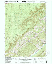 1998 Bear Knob1999 Print · USGSCentre County's rugged ridge-and-valley landscape is captured here in the late nineties, featuring the community of Unionville at the base of Bald Eagle Mountain. Researchers can trace the Old RR Grade or locate family sites at Oak Ridge Cem and the rural Dicks Run Ch.
End of results
Showing maps 1-7 of 7
Top cities near Rush Township
- Tyrone historical maps
- Philipsburg historical maps
- Warriors Mark Township historical maps
- Graham historical maps
- Bigler historical maps
- Osceola Mills historical maps
See more
Top neighborhoods of Rush Township
- Glass City historical maps
- Earnestville historical maps
- North Philipsburg historical maps
- New Town historical maps
- Casanova historical maps
- Spike Island historical maps
See more
Frequently asked questions
- What are the different types of historical maps available for Rush Township?
- What is the oldest map of Rush Township?
- Where can I purchase historical maps of Rush Township for my home or office?
- Where can I download high-res historical maps of Rush Township?
- Are there historical topographic maps available for Rush Township?
- Is there historical aerial imagery available for Rush Township?
- Where are historical maps of Rush Township sourced from?