1970s Maps of Clinton County, Pennsylvania
Explore 5 historic maps of Clinton County from the 1970s. These maps offer a rare glimpse into what life looked like during the 1970s — showing old roads, neighborhoods, homes, and landmarks that have changed or disappeared over time.
Whether you're researching your family's past, planning a metal detecting trip, or studying how Clinton County's landscape evolved across the 1970s, these high-resolution maps are a powerful tool for exploring the history of this region.
- Focus on a specific era: All maps on this page are from the 1970s, giving you a focused view of this time period.
- See what’s changed: Compare century-old streets, trails, and buildings to today's modern landscape using overlays and satellite layers.
- Research with precision: Use these maps for genealogy, historical research, land use analysis, or educational projects.
- View, download, or print: Maps are fully viewable online in high resolution, and can be downloaded or printed for your own records.
Start exploring Clinton County's history through authentic maps from the 1970s. This is your window into the past.
Clinton County, PA maps
(5)- 1971 Map of Warren
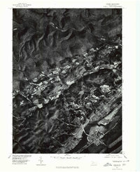
 1971 Warren1971 Print · USGSNorth Central Pennsylvania is captured here in the early seventies, showing a landscape defined by industrial centers and massive state forests. Genealogists and historians can trace the rail lines of the Penn Central and Erie Lackawanna connecting towns like Warren, Kane, and Du Bois.
 - 1977 Map of Beech Creek, 1979 Print
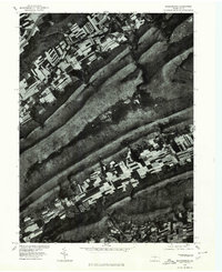
 1977 Beech Creek1979 Print · USGSClinton County land use and valley settlement are captured in this late 1970s aerial survey just as the rural landscape was maturing. Researchers can trace the exact field boundaries and homestead locations near Beech Creek and under the shadow of Bald Eagle Mountain.
 - 1977 Map of Howard, 1979 Print
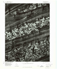
 1977 Howard1979 Print · USGSCentre County farmland and ridges come into sharp focus during the late seventies, showing the rural character of the Pennsylvania landscape. Researchers can trace land use patterns near Howard and Romola or study the shoreline of Sayers Lake.
 - 1977 Map of Madisonburg, 1979 Print
 1977 Madisonburg1979 Print · USGSCentre County's ridge-and-valley landscape is captured in this 1970s orthophotograph, showing the rural character of the region. Local researchers can trace field patterns and land use around Madisonburg, Penn s Valley, and Nittany Mountain.
 - 1977 Map of Millheim, 1979 Print
 1977 Millheim1979 Print · USGSCentral Pennsylvania's Brush Valley is captured here in the late seventies, showing a landscape defined by traditional agriculture and ridge-top forests. Trace the development of Rebersburg and Millheim along the banks of Elk Creek.
End of results
Showing maps 1-5 of 5
Top cities of Clinton County
- Lock Haven historical maps
- Mill Hall historical maps
- Avis historical maps
- Flemington historical maps
- Castanea Township historical maps
- Beech Creek historical maps
See more
Frequently asked questions
- What are the different types of historical maps available for Clinton County?
- What is the oldest map of Clinton County?
- Where can I purchase historical maps of Clinton County for my home or office?
- Where can I download high-res historical maps of Clinton County?
- Are there historical topographic maps available for Clinton County?
- Is there historical aerial imagery available for Clinton County?
- Where are historical maps of Clinton County sourced from?