1940s Maps of Clinton County, Pennsylvania
Explore 27 historic maps of Clinton County from the 1940s. These maps offer a rare glimpse into what life looked like during the 1940s — showing old roads, neighborhoods, homes, and landmarks that have changed or disappeared over time.
Whether you're researching your family's past, planning a metal detecting trip, or studying how Clinton County's landscape evolved across the 1940s, these high-resolution maps are a powerful tool for exploring the history of this region.
- Focus on a specific era: All maps on this page are from the 1940s, giving you a focused view of this time period.
- See what’s changed: Compare century-old streets, trails, and buildings to today's modern landscape using overlays and satellite layers.
- Research with precision: Use these maps for genealogy, historical research, land use analysis, or educational projects.
- View, download, or print: Maps are fully viewable online in high resolution, and can be downloaded or printed for your own records.
Start exploring Clinton County's history through authentic maps from the 1940s. This is your window into the past.
Clinton County, PA maps
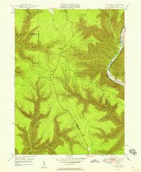
(27)- 1941 Map of Millheim
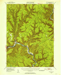
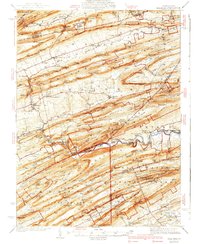 1941 Millheim1941 Print · USGSCentral Pennsylvania's ridge-and-valley landscape is documented here just before the mid-century, showing a network of mountain gaps and small valley settlements. Researchers can locate family landmarks like Wolfs Chapel, the Hironimus Sch, and the BM Sawmill along the banks of Penns Creek.3 unique versions available
 - 1943 Map of Hyner
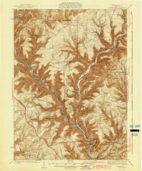
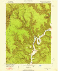
 1943 Hyner1943 Print · USGSIn the central Pennsylvania highlands during the mid-1940s, the river and rail lines dictated the life of the valley. Researchers can trace the industrial corridor from Renovo Boro to remote outposts like Slate Run and Young Womanstown.
 - 1943 Map of Waterville
 1943 Waterville1943 Print · USGSLycoming County mountain life in the early 1940s centers on the river junctions and rail sidings of the Pine Creek valley. Genealogists and hikers can trace old routes like the Silver Springs Road or find forgotten sites like Ross Siding, Carsontown, and Springer Sch.3 unique versions available
 - 1943 Map of Lewistown
 1943 Lewistown1943 Print · USGSCentral Pennsylvania's rugged ridge-and-valley landscape is documented here during the mid-forties, showing the deep integration of rail lines and mountain gaps. Genealogists can trace family footprints through numerous rural landmarks like Emma Chapel, Mattern Junction, and the McNitt School.
 - 1944 Map of Williamsport
 1944 Williamsport1944 Print · USGSThe West Branch Susquehanna River valley was a bustling corridor of industry and agriculture during the mid-forties. Researchers can trace the Pennsylvania RR through Linden Station or find rural schools like Riedy School and the Captain Greene Monument.
 - 1944 Map of Lock Haven
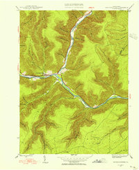
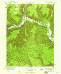
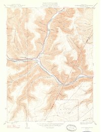
 1944 Lock Haven1944 Print · USGSClinton County during the mid-forties shows a landscape defined by the river-and-rail economy and its transition to early aviation. Genealogists can trace family names at rural sites like Gravel Hill School, Fairpoint Church, and the industrial village of Woolrich.
 - 1945 Map of Driftwood, 1953 Print
 1945 Driftwood1953 Print · USGSCameron County communities thrive along the river bends and rail lines at the end of World War II. Researchers can trace the dual rail paths of the Pennsylvania and Baltimore and Ohio railroads through Driftwood and locate the First Fork Sch.4 unique versions available
 - 1945 Map of Sinnemahoning, 1954 Print
 1945 Sinnemahoning1954 Print · USGSSinnemahoning and the surrounding river valleys are captured here at the height of the steam-to-diesel rail transition. Historians can trace the competing paths of the Pennsylvania and Baltimore and Ohio railroads through Jericho and past Miller Cem.5 unique versions available
 - 1946 Map of Young Womans Creek
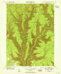 1946 Young Womans Creek1946 Print · USGSClinton County and the surrounding high ridges were deeply forested and sparsely settled in the late 1940s. Genealogists and historians can trace old timber and utility routes like the Underground Pipe Line, Greenlick Road, and the curiously named Bobsled Trail.4 unique versions available
 - 1946 Map of Renovo East, 1953 Print
 1946 Renovo East1953 Print · USGSThe industrial corridor of the West Branch Susquehanna River is seen here in the mid-1940s, showing the critical rail infrastructure of the Pennsylvania railroad. Genealogists can trace family sites in Gleasonton or Farwell and locate the St Josephs Cem.3 unique versions available
 - 1946 Map of Renovo West, 1953 Print
 1946 Renovo West1953 Print · USGSClinton County's river valleys and ridgelines come alive in this mid-century survey of the Pennsylvania wilds. Trace the industrial footprint of the Pennsylvania RR through Renovo or find family history at Laurel Hill Cem and Summerson Cem.9 unique versions available
 - 1946 Map of Hammersley Fork, 1954 Print
 1946 Hammersley Fork1954 Print · USGSThe deep valleys of north-central Pennsylvania appear just after the war as small creek-side settlements remain the primary nodes of local life. Genealogists can trace family names at Summerson Cem and McCoy Cem or locate the old Central Sch near Hammersley Fork.4 unique versions available
 - 1946 Map of Keating, 1954 Print
 1946 Keating1954 Print · USGSClinton County’s deep river valleys and high ridges are shown just after the war, centered on the strategic rail junction at Keating. Genealogists and industrial historians can trace the New York Central line through the mountains and locate the settlement at Bitumen.4 unique versions available
 - 1946 Map of Tamarack, 1955 Print
 1946 Tamarack1955 Print · USGSClinton and Potter Counties appear in the mid-forties as a landscape of deep valleys and vital watershed headwaters. Genealogists and historians can trace the remote highlands surrounding Tamarack, locating local landmarks like Browns Mill and the Tamarack Lookout Tower.4 unique versions available
 - 1946 Map of Slate Run, 1958 Print
 1946 Slate Run1958 Print · USGSThe wilderness of Lycoming and Clinton counties comes into focus in the mid-1940s, highlighting the riverside rail economy and high-plateau landmarks. Genealogists and researchers can trace the New York Central railroad, the Slate Run settlement, and the Pump Station Fire Tower.4 unique versions available
 - 1946 Map of Renovo East, 1958 Print
 1946 Renovo East1958 Print · USGSThe West Branch Susquehanna River valley near Renovo is seen here just after the war, showing the industrial pulse of the river and rail lines. Genealogists and historians can locate Fairview Cem, the St Josephs Ch, and old settlements like Gleasonton and Farwell.4 unique versions available
 - 1946 Map of Renovo West, 1959 Print
 1946 Renovo West1959 Print · USGSClinton County during the post-war era shows a landscape of river-valley industry and upland extraction. You can trace the rail networks through Renovo, find family plots at Noyes Cem, and locate the Strip Mine operations above Westport.4 unique versions available
 - 1946 Map of Glen Union, 1964 Print
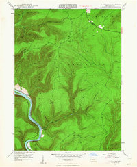 1946 Glen Union1964 Print · USGSThe West Branch Susquehanna River valley in the mid-1940s reveals a landscape of isolated river settlements and steep timbered hollows. Genealogists and historians can trace the early footprints of Glen Union, Whetham, and the Whetham Fire Tower along the river's winding course.5 unique versions available
 - 1947 Map of Sinnemahoning
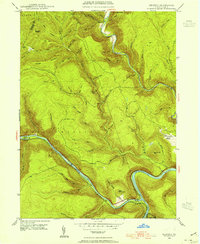
 1947 Sinnemahoning1947 Print · USGSCameron and Clinton counties are depicted in the mid-1940s at a time when the railroad and river defined local life. Genealogists and historians can trace family locations near Sinnemahoning, Driftwood, and Miller Cem, or follow the Baltimore and Ohio line.2 unique versions available
 - 1948 Map of Keating
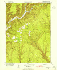
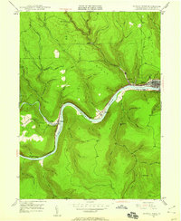
 1948 Keating1948 Print · USGSThe confluence of the Susquehanna and Sinnemahoning Creek appears in the late 1940s as a vital railroad corridor through the mountains. Genealogists and historians can trace the riverside rail stops at Keating and Wistar or the upland community of Bitumen.
 - 1948 Map of Renovo East
 1948 Renovo East1948 Print · USGSClinton County in the late 1940s centers on the busy river corridor of the West Branch Susquehanna River and its mountain settlements. Genealogists and rail historians can trace the Pennsylvania RR through Renovo, find resting places at St Josephs Cem, and locate the Hyner Landing Field.
 - 1948 Map of Hammersley Fork
 1948 Hammersley Fork1948 Print · USGSClinton and Potter counties appear here in the late 1940s, highlighting the rural communities nestled along the winding waters of Kettle Creek. Genealogists can locate family landmarks such as Summerson Cem, McCoy Cem, and the Central Sch.2 unique versions available
 - 1948 Map of Tamarack
 1948 Tamarack1948 Print · USGSThe northern reaches of Clinton County are captured here just after the war, showing a landscape defined by deep creek valleys and forest fire lookouts. Researchers can locate the Tamarack Lookout Tower, the Cem near Cross Fork, and the distinct boggy terrain of Tamarack Swamp.2 unique versions available
 - 1948 Map of Slate Run
 1948 Slate Run1948 Print · USGSThe Pine Creek Valley near the Lycoming and Clinton county line is shown here just after the war, when the New York Central railroad still served the riverside. Genealogists and hikers can trace the remote hollows and high points like the Pump Station Fire Tower and the Gorge near Slate Run.2 unique versions available
 - 1948 Map of Glen Union
 1948 Glen Union1948 Print · USGSClinton County's river valley and high plateau country are shown in detail here just after the war. Local researchers can locate isolated river settlements like Whetham and Glen Union or trace the winding path of the Bucktail Trail and the Whetham Fire Tower.2 unique versions available
Showing maps 1-25 of 27
Top cities of Clinton County
- Lock Haven historical maps
- Mill Hall historical maps
- Avis historical maps
- Flemington historical maps
- Castanea Township historical maps
- Beech Creek historical maps
See more
Frequently asked questions
- What are the different types of historical maps available for Clinton County?
- What is the oldest map of Clinton County?
- Where can I purchase historical maps of Clinton County for my home or office?
- Where can I download high-res historical maps of Clinton County?
- Are there historical topographic maps available for Clinton County?
- Is there historical aerial imagery available for Clinton County?
- Where are historical maps of Clinton County sourced from?