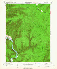
1946 Map of Glen Union
USGS Topo · Published 1964This historical map portrays the area of Glen Union in 1946, primarily covering Clinton County as well as portions of Lycoming County. Featuring a scale of 1:24000, this map provides a highly detailed snapshot of the terrain, roads, buildings, counties, and historical landmarks in the Glen Union region at the time. Published in 1964, it is one of 5 known editions of this map due to revisions or reprints.
Find a feature on this map
42 named features on this map. Tap any name to fly to it.
Don’t see what you’re looking for? This feature index may not catch every label — zoom into the map to look around manually.
Map Details
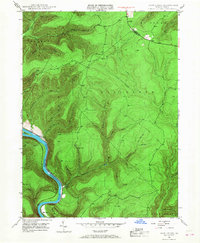
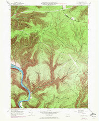
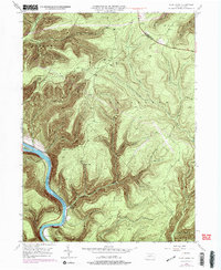
Editions of this 1946 Glen Union Map
5 editions found
Historical Maps of Clinton County Through Time
30 maps found

1921 Howard
Clinton County, PA

1923 Howard
Clinton County, PA

1943 Hyner
Clinton County, PA

1946 Glen Union
Clinton County, PA

1946 Hammersley Fork
Clinton County, PA

1946 Keating
Clinton County, PA

1946 Renovo East
Clinton County, PA

1946 Renovo East
Clinton County, PA

1946 Renovo West
Clinton County, PA

1946 Renovo West
Clinton County, PA

1946 Tamarack
Clinton County, PA

1946 Young Womans Creek
Clinton County, PA

1948 Glen Union
Clinton County, PA

1948 Hammersley Fork
Clinton County, PA

1948 Keating
Clinton County, PA

1948 Renovo East
Clinton County, PA

1948 Tamarack
Clinton County, PA

1949 Renovo West
Clinton County, PA

1949 Young Womans Creek
Clinton County, PA

1959 Pottersdale
Clinton County, PA

1960 Snow Shoe NE
Clinton County, PA

1965 Carroll
Clinton County, PA

1966 Farrandsville
Clinton County, PA

1967 Beech Creek
Clinton County, PA

1967 Howard NW
Clinton County, PA

1977 Beech Creek
Clinton County, PA

1984 Williamsport West
Clinton County, PA

1994 Hammersley Fork
Clinton County, PA

1994 Tamarack
Clinton County, PA

1994 Young Womans Creek
Clinton County, PA
Featured Locations
- Gallagher Township, PA
- McHenry Township, PA
- Glen Union, Grugan Township
- Ritchie, Grugan Township
- Lucullus, McHenry Township