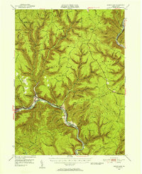
1946 Map of Renovo East
USGS Topo · Published 1956About this map
Susquehanna River corridors and deeply incised valleys define this 1946 survey of northern Pennsylvania, where the West Branch Pennsylvania Canal remnants parallel the modern rail lines. The industrial and transit geography of the mid-century is clear, with the Pennsylvania RR and New York Central RR serving settlements like Renovo, South Renovo, and Gleasonton. In this era before the full decline of the coal and timber transport era, the map captures the transition to newer infrastructure, including the Bucktail Trail and the Hyner Landing Field near the river bend. The landscape is dotted with essential forestry and observation landmarks such as the Whetham Fire Tower and Pamp Station Fire Tower, while the intricate drainage of Young Womans Creek and Hyner Run illustrates the difficult terrain that historically funneled development into the river flats and hollows like Shingle Mill Hollow.
Find a feature on this map
52 named features on this map. Tap any name to fly to it.
Don’t see what you’re looking for? This feature index may not catch every label — zoom into the map to look around manually.
Map Details
Editions of this 1946 Renovo East Map
3 editions found

Other maps of this area

1921 · Howard
USGS Topo · 1:48,000

1921 · Lock Haven
USGS Topo · 1:62,500

1923 · Howard
USGS Topo · 1:62,500

1923 · Lock Haven
USGS Topo · 1:62,500

1928 · Snow Shoe
USGS Topo · 1:48,000

1931 · Show Shoe
USGS Topo · 1:62,500

1937 · Waterville
USGS Topo · 1:48,000

1943 · Hyner
USGS Topo · 1:62,500

1943 · Waterville
USGS Topo · 1:62,500

1944 · Lock Haven
USGS Topo · 1:62,500
Featured Places
- South Renovo, PA
- Gallagher Township, PA
- Lucullus, McHenry Township
- Brown Township, PA
- Ritchie, Grugan Township