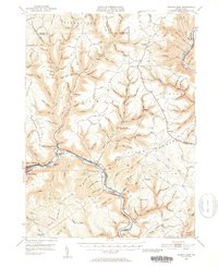
1946 Map of Renovo East
USGS Topo · Published 1953About this map
The Pennsylvania and New York Central railroads parallel the West Branch Susquehanna River in this 1940s survey of Clinton County. This corridor serves as the primary artery for mountain settlements such as North Bend, Renovo, and South Renovo, where industrial and transit activity centers on the valley floor. The historic Bucktail Trail follows the northern bank, passing St Josephs Ch and the remote Gleasonton station.
Find a feature on this map
149 named features on this map. Tap any name to fly to it.
Don’t see what you’re looking for? This feature index may not catch every label — zoom into the map to look around manually.
Map Details
Editions of this 1946 Renovo East Map
3 editions found

Other maps of this area

1921 · Howard
USGS Topo · 1:48,000

1921 · Lock Haven
USGS Topo · 1:62,500

1923 · Howard
USGS Topo · 1:62,500

1923 · Lock Haven
USGS Topo · 1:62,500

1928 · Snow Shoe
USGS Topo · 1:48,000

1931 · Show Shoe
USGS Topo · 1:62,500

1937 · Waterville
USGS Topo · 1:48,000

1943 · Hyner
USGS Topo · 1:62,500

1943 · Waterville
USGS Topo · 1:62,500

1944 · Lock Haven
USGS Topo · 1:62,500
Featured Places
- South Renovo, PA
- Gallagher Township, PA
- Lucullus, McHenry Township
- Brown Township, PA
- Ritchie, Grugan Township