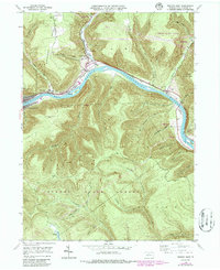
1946 Map of Renovo East
USGS Topo · Published 1986About this map
The West Branch Susquehanna River carves a deep valley through the heart of the Sproul State Forest, defining the industrial and residential development of this Clinton County region. Post-war rail infrastructure is dominated by the Conrail line, which follows the river's north bank through the railroad town of Renovo and nearby Farwell. The geography here is one of narrow habitable corridors between high ridges like Summerson Mountain and Hyner Mountain. Along the northern bends of the river, the settlements of North Bend and Gleasonton sit at the mouth of Young Womans Creek. Genealogical markers are concentrated in the valley, including St Josephs Ch and Fairview Cem, while the emergence of mid-century recreation is evident at Hyner Run State Park and the long-distance Bucktail Trail. A small Landing Field on the river's southern bank near McCloskey Island further illustrates the era's evolving transportation landscape.
Find a feature on this map
47 named features on this map. Tap any name to fly to it.
Don’t see what you’re looking for? This feature index may not catch every label — zoom into the map to look around manually.
Map Details
Editions of this 1946 Renovo East Map
4 editions found

Other maps of this area

1921 · Howard
USGS Topo · 1:48,000

1923 · Howard
USGS Topo · 1:62,500

1928 · Snow Shoe
USGS Topo · 1:48,000

1931 · Show Shoe
USGS Topo · 1:62,500

1943 · Hyner
USGS Topo · 1:62,500

1946 · Young Womans Creek
USGS Topo · 1:24,000

1946 · Renovo East
USGS Topo · 1:62,500

1946 · Renovo West
USGS Topo · 1:62,500

1946 · Tamarack
USGS Topo · 1:24,000

1946 · Slate Run
USGS Topo · 1:24,000
Featured Places
- South Renovo, PA
- Gleasonton, Chapman Township
- Noyes Township, PA
- Grugan Township, PA
- North Bend, Chapman Township