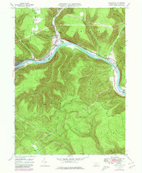
1946 Map of Renovo East
USGS Topo · Published 1980About this map
The West Branch Susquehanna River cuts a deep, winding course through the high plateaus of Clinton County, defining the industrial and social layout of this mid-century landscape. The Penn Central railroad parallels the riverbanks, serving the concentrated river towns of Renovo, South Renovo, and Farwell. This corridor was a vital transportation artery, further emphasized by the Bucktail Trail highway winding along the northern shore through North Bend and Gleasonton.
Find a feature on this map
52 named features on this map. Tap any name to fly to it.
Don’t see what you’re looking for? This feature index may not catch every label — zoom into the map to look around manually.
Map Details
Editions of this 1946 Renovo East Map
4 editions found

Other maps of this area

1921 · Howard
USGS Topo · 1:48,000

1923 · Howard
USGS Topo · 1:62,500

1928 · Snow Shoe
USGS Topo · 1:48,000

1931 · Show Shoe
USGS Topo · 1:62,500

1943 · Hyner
USGS Topo · 1:62,500

1946 · Young Womans Creek
USGS Topo · 1:24,000

1946 · Renovo East
USGS Topo · 1:62,500

1946 · Renovo West
USGS Topo · 1:62,500

1946 · Tamarack
USGS Topo · 1:24,000

1946 · Slate Run
USGS Topo · 1:24,000
Featured Places
- South Renovo, PA
- Gleasonton, Chapman Township
- Noyes Township, PA
- Grugan Township, PA
- North Bend, Chapman Township