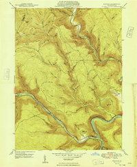
1948 Map of Keating
USGS Topo · Published 1948About this map
The confluence of the West Branch Susquehanna River and Sinnemahoning Creek anchors this 1940s landscape, a rugged section of Clinton County defined by narrow river valleys and high ridges like Savage Mountain. Small settlements such as Keating, Bitumen, and Wistar cling to the riverbanks and hillsides, illustrating the isolated nature of mountain life before the mid-century expansion of modern highways.
Find a feature on this map
63 named features on this map. Tap any name to fly to it.
Don’t see what you’re looking for? This feature index may not catch every label — zoom into the map to look around manually.
Map Details
Editions of this 1948 Keating Map
This is the sole edition of this map. No revisions or reprints were ever made.
Other maps of this area

1928 · Snow Shoe
USGS Topo · 1:48,000

1929 · Karthaus
USGS Topo · 1:62,500

1931 · Show Shoe
USGS Topo · 1:62,500

1932 · Karthaus
USGS Topo · 1:62,500

1945 · Driftwood
USGS Topo · 1:48,000

1945 · First Fork
USGS Topo · 1:24,000

1945 · Sinnemahoning
USGS Topo · 1:24,000

1946 · Renovo West
USGS Topo · 1:62,500

1946 · Hammersley Fork
USGS Topo · 1:24,000

1946 · Keating
USGS Topo · 1:24,000
Featured Places
- Leidy Township, PA
- Bitumen, Noyes Township
- East Keating Township, PA
- Beech Creek Township, PA
- Burnside Township, PA