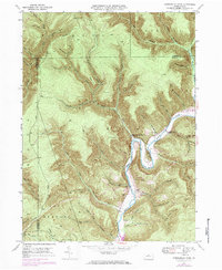
1946 Map of Hammersley Fork
USGS Topo · Published 1984About this map
Kettle Creek carves a dramatic serpentine course through this portion of north-central Pennsylvania, defining the development of the small settlements of Leidy and Hammersley Fork. The 1946 topography, updated in the 1970s, reveals a landscape where human activity is concentrated along the narrow valley floor and its immediate tributaries, including Trout Run and Hammersley Fork. Significant for genealogical research, the map identifies several family-named burial sites such as Calhoun Cem, McCoy Cem, and Summerson Cem. A distinct industrial footprint is evident from the Pipeline corridors crossing the high ridges of Trout Run Mtn and Fork Hill. The transition of the valley is further marked by the planned inundation area for the Alvin R. Bush Dam, which significantly altered the local geography along the Kettle Creek basin.
Find a feature on this map
66 named features on this map. Tap any name to fly to it.
Don’t see what you’re looking for? This feature index may not catch every label — zoom into the map to look around manually.
Map Details
Editions of this 1946 Hammersley Fork Map
4 editions found
Other maps of this area

1945 · Driftwood
USGS Topo · 1:48,000

1945 · First Fork
USGS Topo · 1:24,000

1945 · Sinnemahoning
USGS Topo · 1:24,000

1946 · Renovo West
USGS Topo · 1:62,500

1946 · Hammersley Fork
USGS Topo · 1:24,000

1946 · Keating
USGS Topo · 1:24,000

1946 · Tamarack
USGS Topo · 1:24,000

1946 · Renovo West
USGS Topo · 1:24,000

1947 · First Fork
USGS Topo · 1:24,000

1947 · Sinnemahoning
USGS Topo · 1:24,000
Featured Places
- Leidy Township, PA
- Wharton Township, PA
- East Keating Township, PA
- Grove Township, PA
- Hammersley Fork, Leidy Township