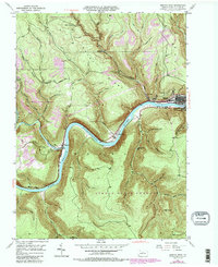
1946 Map of Renovo West
USGS Topo · Published 1987About this map
The Susquehanna River carves a deep valley through the center of this map, serving as the primary corridor for industry and settlement in Clinton County. At the river's bend, the town of Renovo and its neighbors West Renovo and South Renovo are tightly packed against the steep terrain, anchored by the Conrail line and the Bucktail Highway. The surrounding landscape is dominated by the Sproul State Forest, where numerous named hollows like Left Fork Stink Hol and Diamond Rock Hol drain toward the river. Historically significant sites are scattered along the valley floor, including St Josephs Cem and Noyes Cem, while a Strip Mine on the eastern ridge indicates the extraction economy of the mid-20th century. To the west, the confluence of Kettle Creek and the river marks the site of Westport, another small settlement defined by its position at the base of Drury Ridge.
Find a feature on this map
53 named features on this map. Tap any name to fly to it.
Don’t see what you’re looking for? This feature index may not catch every label — zoom into the map to look around manually.
Map Details
Editions of this 1946 Renovo West Map
4 editions found

Other maps of this area

1921 · Howard
USGS Topo · 1:48,000

1923 · Howard
USGS Topo · 1:62,500

1928 · Snow Shoe
USGS Topo · 1:48,000

1931 · Show Shoe
USGS Topo · 1:62,500

1943 · Hyner
USGS Topo · 1:62,500

1946 · Young Womans Creek
USGS Topo · 1:24,000

1946 · Renovo East
USGS Topo · 1:62,500

1946 · Renovo West
USGS Topo · 1:62,500

1946 · Hammersley Fork
USGS Topo · 1:24,000

1946 · Keating
USGS Topo · 1:24,000
Featured Places
- Leidy Township, PA
- West Renovo, Noyes Township
- Westport, Noyes Township
- Noyes Township, PA
- Drury Run, Noyes Township