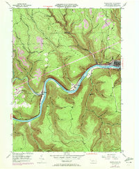
1946 Map of Renovo West
USGS Topo · Published 1971About this map
The West Branch of the Susquehanna River carves a sharp, winding course through the heart of the Noyes area, dictating the development of the river-valley communities. This mid-century landscape reflects the heavy influence of the Penn Central railroad, which runs parallel to the water through industrial and residential hubs like Renovo and South Renovo. The topography is defined by high elevations such as High Knob and Drury Ridge, cut by numerous drainage basins including Kettle Creek and Two Mile Run. Genealogy researchers will find several well-defined burial grounds, such as Robbins Cem and St Josephs Cem, alongside the St Josephs Ch in the Drury Run vicinity. Strip mining activity is noted near Westport, highlighting the extraction history that shaped this section of Clinton County alongside the vital transit artery of the Bucktail Highway.
Find a feature on this map
71 named features on this map. Tap any name to fly to it.
Don’t see what you’re looking for? This feature index may not catch every label — zoom into the map to look around manually.
Map Details
Editions of this 1946 Renovo West Map
4 editions found

Other maps of this area

1921 · Howard
USGS Topo · 1:48,000

1923 · Howard
USGS Topo · 1:62,500

1928 · Snow Shoe
USGS Topo · 1:48,000

1931 · Show Shoe
USGS Topo · 1:62,500

1943 · Hyner
USGS Topo · 1:62,500

1946 · Young Womans Creek
USGS Topo · 1:24,000

1946 · Renovo East
USGS Topo · 1:62,500

1946 · Renovo West
USGS Topo · 1:62,500

1946 · Hammersley Fork
USGS Topo · 1:24,000

1946 · Keating
USGS Topo · 1:24,000
Featured Places
- Leidy Township, PA
- West Renovo, Noyes Township
- Westport, Noyes Township
- Noyes Township, PA
- Drury Run, Noyes Township