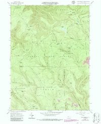
1960 Map of Snow Shoe NE
USGS Topo · Published 1986About this map
Sproul State Forest dominates this topographic study of northern Pennsylvania, revealing a landscape defined by seasonal camps and hunting culture. The terrain is deeply incised by the Dennison Fork and Fish Dam Run, with numerous private outposts such as Camp Chestnut Hill and The Hemlocks Camp tucked into the hollows. These sites, along with the Bald Hill Hunting Club, speak to the region's long-standing tradition of forest-based recreation.
Find a feature on this map
71 named features on this map. Tap any name to fly to it.
Don’t see what you’re looking for? This feature index may not catch every label — zoom into the map to look around manually.
Map Details
Editions of this 1960 Snow Shoe NE Map
3 editions found
Other maps of this area

1921 · Howard
USGS Topo · 1:48,000

1923 · Howard
USGS Topo · 1:62,500

1928 · Snow Shoe
USGS Topo · 1:48,000

1931 · Show Shoe
USGS Topo · 1:62,500

1943 · Hyner
USGS Topo · 1:62,500

1946 · Renovo East
USGS Topo · 1:62,500

1946 · Renovo West
USGS Topo · 1:62,500

1946 · Keating
USGS Topo · 1:24,000

1946 · Renovo East
USGS Topo · 1:24,000

1946 · Renovo West
USGS Topo · 1:24,000
Featured Places
- Beech Creek Township, PA
- Burnside Township, PA
- Noyes Township, PA
- Curtin Township, PA
- State Camp, Noyes Township