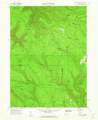
1960 Map of Snow Shoe NE
USGS Topo · Published 1962About this map
Sproul State Forest dominates this landscape along the border of Clinton and Centre Counties, defined by a dense network of hunting camps and wilderness outposts. In the early 1960s, the area remained a prime destination for outdoor recreation and forestry, featuring named locations such as Ralpton Camp, Camp Big Horn, and the Bald Hill Hunting Club. The terrain is deeply incised by drainages like Fish Dam Run and Eddy Lick Run, which flow through steep hollows. While largely preserved for conservation, industrial footprints appear in the form of a Strip Mine and the Jews Pipeline. A Lookout Tower on Shoemaker Ridge provided a high-ground vantage point for fire spotting, reflecting the mid-century management of these extensive Pennsylvania woodlands.
Find a feature on this map
76 named features on this map. Tap any name to fly to it.
Don’t see what you’re looking for? This feature index may not catch every label — zoom into the map to look around manually.
Map Details
Editions of this 1960 Snow Shoe NE Map
3 editions found
Other maps of this area

1921 · Howard
USGS Topo · 1:48,000

1923 · Howard
USGS Topo · 1:62,500

1928 · Snow Shoe
USGS Topo · 1:48,000

1931 · Show Shoe
USGS Topo · 1:62,500

1943 · Hyner
USGS Topo · 1:62,500

1946 · Renovo East
USGS Topo · 1:62,500

1946 · Renovo West
USGS Topo · 1:62,500

1946 · Keating
USGS Topo · 1:24,000

1946 · Renovo East
USGS Topo · 1:24,000

1946 · Renovo West
USGS Topo · 1:24,000
Featured Places
- Beech Creek Township, PA
- Burnside Township, PA
- Noyes Township, PA
- Curtin Township, PA
- State Camp, Noyes Township