1960s Maps of Abbeville County, South Carolina
Explore 6 historic maps of Abbeville County from the 1960s. These maps offer a rare glimpse into what life looked like during the 1960s — showing old roads, neighborhoods, homes, and landmarks that have changed or disappeared over time.
Whether you're researching your family's past, planning a metal detecting trip, or studying how Abbeville County's landscape evolved across the 1960s, these high-resolution maps are a powerful tool for exploring the history of this region.
- Focus on a specific era: All maps on this page are from the 1960s, giving you a focused view of this time period.
- See what’s changed: Compare century-old streets, trails, and buildings to today's modern landscape using overlays and satellite layers.
- Research with precision: Use these maps for genealogy, historical research, land use analysis, or educational projects.
- View, download, or print: Maps are fully viewable online in high resolution, and can be downloaded or printed for your own records.
Start exploring Abbeville County's history through authentic maps from the 1960s. This is your window into the past.
Abbeville County, SC maps
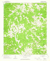
(6)- 1964 Map of Iva
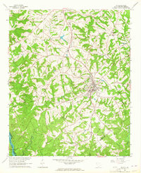 1964 Iva1964 Print · USGSUpper South Carolina in the mid-sixties reveals a landscape of railroad towns and country congregations along the Georgia border. Genealogists can trace family footprints through numerous rural landmarks like Goodhope Cem, Barnes Station, and Pleasant Grove Ch.3 unique versions available
 - 1964 Map of Antreville, 1965 Print
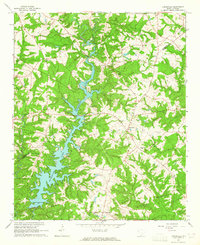 1964 Antreville1965 Print · USGSThe rural border of Abbeville and Anderson counties is captured here in the mid-sixties, centered on the winding waters of Secession Lake. Genealogists can locate numerous landmarks including the Antreville School, Hall-Cromer Cem, and Shiloh Ch.
 - 1964 Map of Lowndesville, 1965 Print
 1964 Lowndesville1965 Print · USGSThe South Carolina and Georgia borderlands near the Savannah River are captured here in the mid-1960s. Genealogists can trace family roots through numerous sites like Old McCalla Cemetery, Smyrna Church, and the Atlantic Coast Line rail corridor.3 unique versions available
 - 1964 Map of Calhoun Falls, 1965 Print
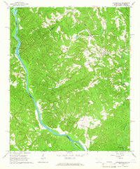
 1964 Calhoun Falls1965 Print · USGSCalhoun Falls and the Savannah River valley are documented here in the mid-sixties as the reservoir transformed the landscape. Trace rail history and family roots via the Atlantic Coast Line, McAllister Chapel, and the Ellison Sch.3 unique versions available
 - 1964 Map of Latimer, 1966 Print
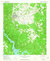
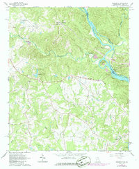
 1964 Latimer1966 Print · USGSAbbeville County during the mid-1960s shows a landscape of established rail lines and quiet rural crossroads. Genealogists can trace family heritage through landmarks like Old Rocky River Cem and congregations at Brown Oaks Ch or Midway Ch.
 - 1964 Map of Heardmont, 1966 Print
 1964 Heardmont1966 Print · USGSElbert County, Georgia, and the South Carolina borderlands are captured here during a period of major infrastructure change in the mid-sixties. Genealogists and researchers can locate numerous country churches and schools like Hunters Chapel, Banks Sch, and New Hope Ch among the river shoals.3 unique versions available
End of results
Showing maps 1-6 of 6
Top cities of Abbeville County
- Abbeville historical maps
- Calhoun Falls historical maps
- Due West historical maps
- Donalds historical maps
- Lowndesville historical maps
Frequently asked questions
- What are the different types of historical maps available for Abbeville County?
- What is the oldest map of Abbeville County?
- Where can I purchase historical maps of Abbeville County for my home or office?
- Where can I download high-res historical maps of Abbeville County?
- Are there historical topographic maps available for Abbeville County?
- Is there historical aerial imagery available for Abbeville County?
- Where are historical maps of Abbeville County sourced from?