1970s Maps of Abbeville County, South Carolina
Explore 7 historic maps of Abbeville County from the 1970s. These maps offer a rare glimpse into what life looked like during the 1970s — showing old roads, neighborhoods, homes, and landmarks that have changed or disappeared over time.
Whether you're researching your family's past, planning a metal detecting trip, or studying how Abbeville County's landscape evolved across the 1970s, these high-resolution maps are a powerful tool for exploring the history of this region.
- Focus on a specific era: All maps on this page are from the 1970s, giving you a focused view of this time period.
- See what’s changed: Compare century-old streets, trails, and buildings to today's modern landscape using overlays and satellite layers.
- Research with precision: Use these maps for genealogy, historical research, land use analysis, or educational projects.
- View, download, or print: Maps are fully viewable online in high resolution, and can be downloaded or printed for your own records.
Start exploring Abbeville County's history through authentic maps from the 1970s. This is your window into the past.
Abbeville County, SC maps
(7)- 1970 Map of Honea Path, 1975 Print
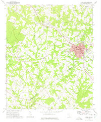 1970 Honea Path1975 Print · USGSHonea Path is shown at a period of transition in the early seventies, where rail lines and rural tradition meet. Genealogists can locate family landmarks like Garden of Memories, Jones Chapel, and the settlement of Craytonville.
 - 1971 Map of Due West, 1975 Print
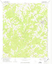 1971 Due West1975 Print · USGSThe Upstate South Carolina piedmont appears here in the early seventies, centered on the academic and historic hub of Due West. Genealogists and historians can trace deep-rooted community ties at Erskine College, Little River Ch, and the rural crossroads of Level Land.
 - 1971 Map of Ware Shoals East, 1975 Print
 1971 Ware Shoals East1975 Print · USGSLaurens County and the surrounding river country are documented here in the early seventies, centered on the industrial and community hubs of the Piedmont. Genealogists can trace family locations near Bethel Ch, Poplar Springs, and the Boyd Millpond shoreline.
 - 1971 Map of Shoals Junction, 1975 Print
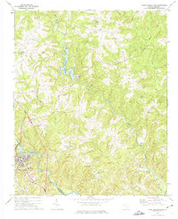
 1971 Shoals Junction1975 Print · USGSThe rural Upstate South Carolina corridor comes into focus in the early seventies, centered on the Shoals Junction rail crossing. Genealogists can trace family roots at Gilgal Cem, Mt Zion Ch, and the growing communities of Due West and Arborville.
 - 1971 Map of Ware Shoals West, 1975 Print
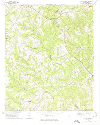
 1971 Ware Shoals West1975 Print · USGSThe Saluda River valley in the early seventies shows a landscape defined by crossing county lines and rail connections. Researchers can trace family roots through the Turkey Creek Cem, visit the settlement of Blue Heaven, or locate the old Drive-in Theater.
 - 1978 Map of Greenwood, 1979 Print
 1978 Greenwood1979 Print · USGSGreenwood at the end of the 1970s shows a thriving regional hub where the SOUTHERN railroad meets a growing network of industrial and residential villages. Researchers can trace family sites at Promised Land, Lander College, and the Maxwell Childrens Home.
 - 1979 Map of Abbeville, 1980 Print
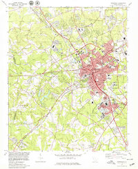
 1979 Abbeville1980 Print · USGSThe South Carolina and Georgia borderlands are captured here during a period of significant hydroelectric development and regional growth. Researchers can trace the rail-and-river economy through the Seaboard Coast Line and landmarks like Hartwell Dam or the Silk Mills.2 unique versions available
End of results
Showing maps 1-7 of 7
Top cities of Abbeville County
- Abbeville historical maps
- Calhoun Falls historical maps
- Due West historical maps
- Donalds historical maps
- Lowndesville historical maps
Frequently asked questions
- What are the different types of historical maps available for Abbeville County?
- What is the oldest map of Abbeville County?
- Where can I purchase historical maps of Abbeville County for my home or office?
- Where can I download high-res historical maps of Abbeville County?
- Are there historical topographic maps available for Abbeville County?
- Is there historical aerial imagery available for Abbeville County?
- Where are historical maps of Abbeville County sourced from?