1980s Maps of Pelion, South Carolina
Explore 3 historic maps of Pelion from the 1980s. These maps offer a rare glimpse into what life looked like during the 1980s — showing old roads, neighborhoods, homes, and landmarks that have changed or disappeared over time.
Whether you're researching your family's past, planning a metal detecting trip, or studying how Pelion's landscape evolved across the 1980s, these high-resolution maps are a powerful tool for exploring the history of this region.
- Focus on a specific era: All maps on this page are from the 1980s, giving you a focused view of this time period.
- See what’s changed: Compare century-old streets, trails, and buildings to today's modern landscape using overlays and satellite layers.
- Research with precision: Use these maps for genealogy, historical research, land use analysis, or educational projects.
- View, download, or print: Maps are fully viewable online in high resolution, and can be downloaded or printed for your own records.
Start exploring Pelion's history through authentic maps from the 1980s. This is your window into the past.
Pelion, SC maps
(3)- 1983 Map of Aiken, 1984 Print
 1983 Aiken1984 Print · USGSThe Savannah River valley and South Carolina sandhills are shown in detail during the early eighties, as industry and education expanded. Researchers can trace the rail corridors of the Southern and Seaboard Coast Line through communities like Graniteville and Leesville.
 - 1986 Map of Pond Branch
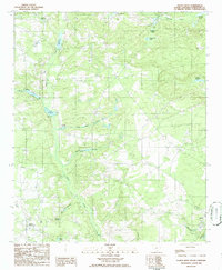
 1986 Pond Branch1986 Print · USGSIn the mid-1980s, the rural borderlands of Lexington and Aiken counties remained a landscape of historic water-powered mills and meandering creeks. Researchers can trace the heritage of local industry at Jeffcoats Millpond, Pooles Millpond, and Kings Pond along the North Fork Edisto River.
 - 1986 Map of Pelion West
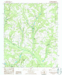
 1986 Pelion West1986 Print · USGSLexington County's rural landscape is captured here in the mid-eighties, showing a region defined by family ponds and crossroad communities. Local historians can trace old mill sites like Paxton Millpond and Lucas Millpond, or locate family burial grounds near Fairview Crossroads.
End of results
Showing maps 1-3 of 3
Top cities near Pelion
- Columbia historical maps
- Lexington historical maps
- West Columbia historical maps
- Cayce historical maps
- Springdale historical maps
- South Congaree historical maps
See more
Frequently asked questions
- What are the different types of historical maps available for Pelion?
- What is the oldest map of Pelion?
- Where can I purchase historical maps of Pelion for my home or office?
- Where can I download high-res historical maps of Pelion?
- Are there historical topographic maps available for Pelion?
- Is there historical aerial imagery available for Pelion?
- Where are historical maps of Pelion sourced from?