1980s Maps of Marion County, South Carolina
Explore 4 historic maps of Marion County from the 1980s. These maps offer a rare glimpse into what life looked like during the 1980s — showing old roads, neighborhoods, homes, and landmarks that have changed or disappeared over time.
Whether you're researching your family's past, planning a metal detecting trip, or studying how Marion County's landscape evolved across the 1980s, these high-resolution maps are a powerful tool for exploring the history of this region.
- Focus on a specific era: All maps on this page are from the 1980s, giving you a focused view of this time period.
- See what’s changed: Compare century-old streets, trails, and buildings to today's modern landscape using overlays and satellite layers.
- Research with precision: Use these maps for genealogy, historical research, land use analysis, or educational projects.
- View, download, or print: Maps are fully viewable online in high resolution, and can be downloaded or printed for your own records.
Start exploring Marion County's history through authentic maps from the 1980s. This is your window into the past.
Marion County, SC maps
(4)- 1983 Map of Florence, 1985 Print
 1983 Florence1985 Print · USGSThe Pee Dee region in the early eighties shows a landscape shaped by river commerce and rail expansion. Researchers can trace historic river crossings at Galivants Ferry or locate vanished rail stops like Willow Creek Siding and Blue Brick.
 - 1986 Map of Kingstree
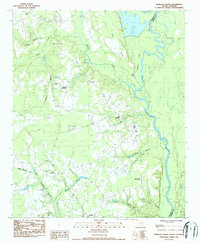
 1986 Kingstree1986 Print · USGSThe South Carolina Lowcountry in the mid-eighties shows a landscape defined by the Black River and the growing coastal communities of the Grand Strand. Researchers can trace historic river settlements and rail stops like Salters Depot, Pamplico, and Hemingway.2 unique versions available
 - 1986 Map of Pee Dee, 1987 Print
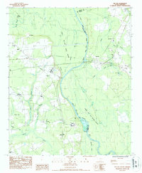 1986 Pee Dee1987 Print · USGSThe Great Pee Dee River lowlands are shown here in the late 1970s, marking the crossroads of Florence and Marion counties. Genealogists can locate rural landmarks like Bowers Chapel, Mars Bluff, and the small settlement of Blue Brick.
 - 1986 Map of Pamplico North, 1987 Print
 1986 Pamplico North1987 Print · USGSThe Pee Dee riverfront and rural Florence County are captured here in the mid-eighties, showing a landscape of traditional crossroads and river bends. Genealogists can locate family landmarks such as Willow Creek Ch, Davistown, and Pleasant Hill Cem.
End of results
Showing maps 1-4 of 4
Top cities of Marion County
Frequently asked questions
- What are the different types of historical maps available for Marion County?
- What is the oldest map of Marion County?
- Where can I purchase historical maps of Marion County for my home or office?
- Where can I download high-res historical maps of Marion County?
- Are there historical topographic maps available for Marion County?
- Is there historical aerial imagery available for Marion County?
- Where are historical maps of Marion County sourced from?