Old Maps of Marion County, South Carolina for Genealogy
Trace your family roots with 39 historic maps of Marion County. These high-res maps reveal old neighborhoods, homesites, landmarks, and streets — helping you uncover where your ancestors lived and how the area evolved over time.
- Explore historic neighborhoods: Identify where your relatives may have lived in the 1800s or 1900s.
- Compare maps over time: Trace the changes in streets, buildings, and landmarks for multi-generational research.
- Perfect for genealogy & ancestry research: Used by family historians and researchers to map out lineage and migration.
These maps are an incredible resource for exploring your personal connection to Marion County's past.
Marion County, SC maps
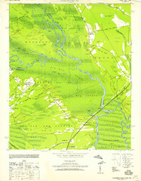
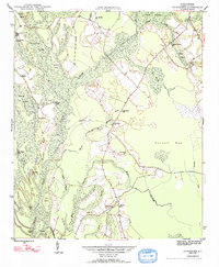
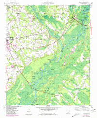
(39)- 1940 Map of Florence East, 1971 Print
 1940 Florence East1971 Print · USGSCovers Marion County, including Florence, Pamplico, and other nearby areas
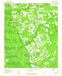
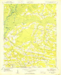
 - 1943 Map of Pages Mill
 1943 Pages Mill1943 Print · USGSCovers Marion County, including Fairmont, Fair Bluff, and other nearby areas
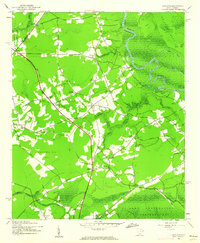
 - 1943 Map of Gum Swamp
 1943 Gum Swamp1943 Print · USGSCovers Marion County, including Blenheim, Oak Grove, and other nearby areas
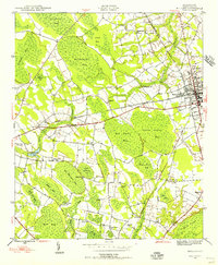
 - 1943 Map of Yauhannah, 1958 Print
 1943 Yauhannah1958 Print · USGSCovers Marion County, including Petersfield, Gilbert Crossroads, and other nearby areas3 unique versions available
 - 1943 Map of Dongola, 1962 Print
 1943 Dongola1962 Print · USGSCovers Marion County, including Ned Swamp, Dongola, and other nearby areas2 unique versions available
 - 1943 Map of Outland, 1962 Print
 1943 Outland1962 Print · USGSCovers Marion County, including Good Hope, Pope Crossroads, and other nearby areas2 unique versions available
 - 1944 Map of Outland
 1944 Outland1944 Print · USGSCovers Marion County, including Good Hope, Pope Crossroads, and other nearby areas
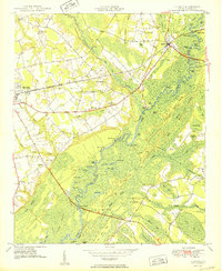
 - 1945 Map of Florence East
 1945 Florence East1945 Print · USGSCovers Marion County, including Florence, Pamplico, and other nearby areas
 - 1946 Map of Hyman
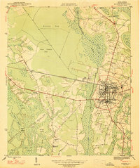
 1946 Hyman1946 Print · USGSCovers Marion County, including Lake City, Pamplico, and other nearby areas
 - 1946 Map of Johnsonville
 1946 Johnsonville1946 Print · USGSCovers Marion County, including Johnsonville, Hemingway, and other nearby areas
 - 1946 Map of Mullins, 1956 Print
 1946 Mullins1956 Print · USGSCovers Marion County, including Marion, Mullins, and other nearby areas4 unique versions available
 - 1947 Map of Friendship
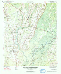
 1947 Friendship1947 Print · USGSCovers Marion County, including Tabernacle, Friendship, and other nearby areas2 unique versions available
 - 1947 Map of Marion
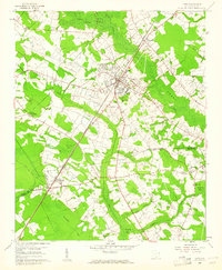
 1947 Marion1947 Print · USGSCovers Marion County, including Marion, Laughlin, and other nearby areas
 - 1947 Map of Centenary
 1947 Centenary1947 Print · USGSCovers Marion County, including Centenary, Davis Landing, and other nearby areas2 unique versions available
 - 1947 Map of Mullins
 1947 Mullins1947 Print · USGSCovers Marion County, including Marion, Mullins, and other nearby areas
 - 1948 Map of Galivants Ferry, 1981 Print
 1948 Galivants Ferry1981 Print · USGSCovers Marion County, including Aynor, Galivants Ferry, and other nearby areas
 - 1948 Map of Nichols, 1981 Print
 1948 Nichols1981 Print · USGSCovers Marion County, including Mullins, Nichols, and other nearby areas
 - 1949 Map of Georgetown, 1953 Print
 1949 Georgetown1953 Print · USGSCovers Marion County, including Goose Creek, Myrtle Beach, and other nearby areas
 - 1950 Map of Galivants Ferry
 1950 Galivants Ferry1950 Print · USGSCovers Marion County, including Aynor, Galivants Ferry, and other nearby areas2 unique versions available
 - 1950 Map of Nichols
 1950 Nichols1950 Print · USGSCovers Marion County, including Mullins, Nichols, and other nearby areas
 - 1953 Map of Florence, 1964 Print
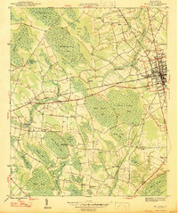
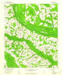
 1953 Florence1964 Print · USGSCovers Marion County, including Fayetteville, Florence, and other nearby areas3 unique versions available
 - 1954 Map of Florence
 1954 Florence1954 Print · USGSCovers Marion County, including Fayetteville, Florence, and other nearby areas
 - 1959 Map of Fork, 1961 Print
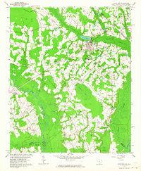
 1959 Fork1961 Print · USGSCovers Marion County, including Fork, Pittman Corner, and other nearby areas
 - 1960 Map of Latta, 1961 Print
 1960 Latta1961 Print · USGSCovers Marion County, including Sellers, Temperance Hill, and other nearby areas2 unique versions available
 - 1962 Map of Lake View, 1964 Print
 1962 Lake View1964 Print · USGSCovers Marion County, including Lake View, Marietta, and other nearby areas
Showing maps 1-25 of 39
Top cities of Marion County
Frequently asked questions
- What are the different types of historical maps available for Marion County?
- What is the oldest map of Marion County?
- Where can I purchase historical maps of Marion County for my home or office?
- Where can I download high-res historical maps of Marion County?
- Are there historical topographic maps available for Marion County?
- Is there historical aerial imagery available for Marion County?
- Where are historical maps of Marion County sourced from?