Old Maps of Marion County, South Carolina for Metal Detecting
Plan your next treasure hunt with 139 historic maps of Marion County. Find old homesites, ghost towns, trails, and gathering spots that may be lost to time — perfect for identifying promising metal detecting locations.
- Locate forgotten sites: Uncover places like long-lost settlements, abandoned rail lines, or gathering spots.
- Plan better hunts: Use map overlays combined with LiDAR or satellite views to narrow in on historically rich areas.
- Made for detectorists: Thousands of hobbyists use these maps to discover relics, coins, and hidden history.
Use these historic maps to boost your research and find new opportunities beneath the surface of Marion County.
Marion County, SC maps
(139)- 1940 Map of Florence East, 1971 Print
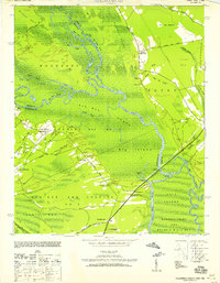
 1940 Florence East1971 Print · USGSThe Pee Dee region just before the Second World War shows a landscape defined by riverside landings and rural rail stops. Genealogists can locate family-named landmarks and community hubs like Browns Old Mill, Tabernacle Sch, and Hewitt Cem.
 - 1943 Map of Pages Mill
 1943 Pages Mill1943 Print · USGSThe Carolina borderlands come alive in the 1940s, showing a landscape shaped by the Lumber River and the Atlantic Coast Line railroad. Genealogists can trace family names through numerous rural landmarks like Oliver Cross Roads, Tabernacle Ch, and White Pond Ch & Sch.
 - 1943 Map of Gum Swamp
 1943 Gum Swamp1943 Print · USGSCoastal plain settlements and river islands define the Pee Dee region during the early years of World War II. Researchers can locate rural hubs like Bethea Cross Roads and trace family history through landmarks like Lower Marlboro High School and Annarate Church.2 unique versions available
 - 1943 Map of Yauhannah, 1958 Print
 1943 Yauhannah1958 Print · USGSThe South Carolina lowcountry is captured here in the mid-1940s, showing a river-driven landscape of swamps and isolated settlements. Researchers can trace rural life through landmarks like Gravel Gully School, the Yauhannah Church and Cem, and the old Lucas Bay Plantation.4 unique versions available
 - 1943 Map of Dongola, 1962 Print
 1943 Dongola1962 Print · USGSHorry County during the 1940s reveals a landscape of river-bottom settlements and winding swamp channels. Genealogists can trace family roots through numerous local landmarks like Old Antioch Ch, Singleton Crossroads, and the rural community of Dongola.2 unique versions available
 - 1943 Map of Outland, 1962 Print
 1943 Outland1962 Print · USGSGeorgetown County at the height of the war years reveals a landscape of river landings and rural crossroads. You can trace family roots through numerous sites like Hucks Field Cem, Huggins Crossroads, and Jerusalem Ch.2 unique versions available
 - 1944 Map of Outland
 1944 Outland1944 Print · USGSGeorgetown and Williamsburg counties during the Second World War reveal a landscape of dense swamps and strategic military zones. Researchers can trace family history through numerous rural sites like Deep Creek School, Walkers Chapel, and the Hucks Field Cem.
 - 1945 Map of Florence East
 1945 Florence East1945 Print · USGSThe Pee Dee region of South Carolina was a web of rail lines and river landings in the years following the second World War. Researchers can trace the heritage of local communities at Browns Old Mill, Mars Bluff, and rural schoolhouses like Red Hill Sch.2 unique versions available
 - 1946 Map of Hyman
 1946 Hyman1946 Print · USGSCoastal plain settlements and river landings define this mid-1940s survey of the Florence and Williamsburg county line. Researchers can trace family history through numerous rural landmarks like the Leo Post Office, Gause Cem, and Prosser Tabernacle.
 - 1946 Map of Johnsonville
 1946 Johnsonville1946 Print · USGSThe Pee Dee River basin and its surrounding swamplands are captured here in the mid-1940s, showing a landscape defined by river landings and rural crossroads. Genealogists and historians can locate dozens of country churches and schools, from Buzzard Skull Ch to the Gunter Island School.
 - 1946 Map of Mullins, 1956 Print
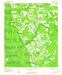
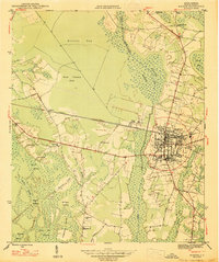
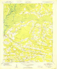
 1946 Mullins1956 Print · USGSMarion County was an active railroad and agricultural hub in the mid-1940s, centered on the junction of two major rail lines. Genealogists can trace rural family roots through landmarks like Livingston Cem, Gapway Sch, and Little Bethel Ch.4 unique versions available
 - 1947 Map of Friendship
 1947 Friendship1947 Print · USGSMarion County in the late 1940s reveals a landscape of interconnected wetlands and small rural communities. Researchers can trace ancestral connections through numerous landmarks like Kirton Cem, Weeping Willow Sch, and the community of Friendship.2 unique versions available
 - 1947 Map of Marion
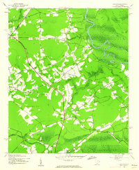
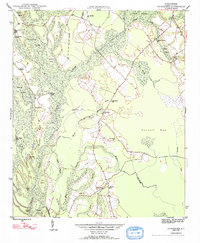
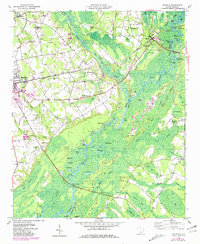
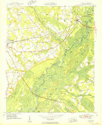
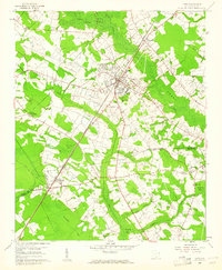
 1947 Marion1947 Print · USGSMarion emerges as a post-war rail and agricultural hub in the late 1940s, situated between significant wetlands and the Atlantic Coast Line. Researchers can trace rural community life through landmarks like Singletary Ch, Springville Sch, and Rose Hill Cem.3 unique versions available
 - 1947 Map of Centenary
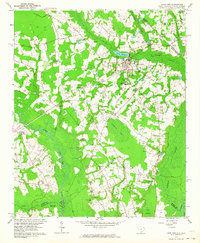
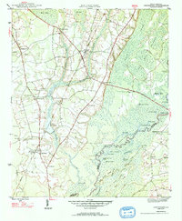 1947 Centenary1947 Print · USGSMarion County is documented here in the mid-1940s, showing a rural landscape defined by the winding Little Pee Dee River and the Seaboard Air Line railroad. Genealogists can trace family footprints through sites like Beauty Spot Sch, Palmer Cem, and the community of Centenary.3 unique versions available
 - 1947 Map of Mullins
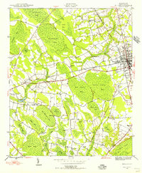
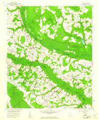
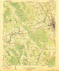 1947 Mullins1947 Print · USGSMarion County at the close of the 1940s is a landscape of intersecting railroads and unique Carolina Bays. Researchers can trace rural life through sites like Smith Swamp Sch, Wise Chapel, and numerous family burials including Ammons Cem.2 unique versions available
 - 1948 Map of Galivants Ferry, 1981 Print
 1948 Galivants Ferry1981 Print · USGSThe rural landscape of Horry and Marion counties comes alive in the mid-twentieth century as communities shifted from river landings to crossroads commerce. Genealogists can trace family landmarks and rural school sites like Ketchuptown, Galivants Ferry, and Mill Swamp Sch.
 - 1948 Map of Nichols, 1981 Print
 1948 Nichols1981 Print · USGSMarion and Horry counties are shown here at the mid-century, where the Little Pee Dee River meets the Lumber River. Researchers can trace the river economy through historic landings and crossings like Grice Ferry, Pitch Landing, and Sandy Bluff Bridge.
 - 1949 Map of Georgetown, 1953 Print
 1949 Georgetown1953 Print · USGSThe South Carolina coast and North Carolina borderlands appear here in the mid-century, prior to the major modern development of the Grand Strand. Genealogists and historians can trace the rail networks of the Seaboard Air Line Railroad and locate coastal landmarks from Fort Caswell to McClellanville.
 - 1950 Map of Galivants Ferry
 1950 Galivants Ferry1950 Print · USGSHorry County in the mid-twentieth century was a landscape of river landings and rural crossroads. Local historians can trace family roots through sites like Sandy Plains Ch, the community at Ketchuptown, and landings along the Little Pee Dee River.3 unique versions available
 - 1950 Map of Nichols
 1950 Nichols1950 Print · USGSIn the mid-twentieth century, the Little Pee Dee River bottomlands shaped the communities of Mullins and Nichols. Local historians can trace early river crossings like Grice Ferry, rural church sites like Mt Zion Ch, and family landmarks across the Big Sand Hills Back Swamp.2 unique versions available
 - 1953 Map of Florence, 1964 Print
 1953 Florence1964 Print · USGSThe Carolina borderlands in the mid-fifties were a landscape of vast river swamps and rising rail towns. Trace the legacy of the Seaboard Air Line through Florence or explore the wetlands surrounding Lake Waccamaw and the Green Swamp.3 unique versions available
 - 1954 Map of Florence
 1954 Florence1954 Print · USGSThe Carolinas borderlands come alive in the early fifties, showing the vital rail-and-river networks of the coastal plain. Genealogists can trace family footprints across the Green Swamp or through settlements like Red Springs, Chadbourn, and McColl.
 - 1959 Map of Fork, 1961 Print
 1959 Fork1961 Print · USGSThe rural lowcountry of the Pee Dee region is captured here in the late fifties, showing a landscape of small farming communities and timbered wetlands. Genealogists can trace family footprints near Floydale, Spring Grove Ch, and the Watson Cem.
 - 1960 Map of Latta, 1961 Print
 1960 Latta1961 Print · USGSDillon and Marion Counties are captured here in the early 1960s, showing a rural landscape defined by the Atlantic Coast Line railroad. Genealogists can trace family landmarks like Magnolia Cem, Sardis Ch, and the outlying settlement of Temperance Hill.2 unique versions available
 - 1962 Map of Lake View, 1964 Print
 1962 Lake View1964 Print · USGSThe South Carolina and North Carolina borderlands are captured here in the early sixties, showing the transition from old rail corridors to a landscape of millponds and rural crossroads. Genealogists can trace family landmarks like High Hill Crossroads, Pages Millpond, and Squires Pork Church.
Showing maps 1-25 of 139
Top cities of Marion County
Frequently asked questions
- What are the different types of historical maps available for Marion County?
- What is the oldest map of Marion County?
- Where can I purchase historical maps of Marion County for my home or office?
- Where can I download high-res historical maps of Marion County?
- Are there historical topographic maps available for Marion County?
- Is there historical aerial imagery available for Marion County?
- Where are historical maps of Marion County sourced from?