1960s Maps of Marion County, South Carolina
Explore 4 historic maps of Marion County from the 1960s. These maps offer a rare glimpse into what life looked like during the 1960s — showing old roads, neighborhoods, homes, and landmarks that have changed or disappeared over time.
Whether you're researching your family's past, planning a metal detecting trip, or studying how Marion County's landscape evolved across the 1960s, these high-resolution maps are a powerful tool for exploring the history of this region.
- Focus on a specific era: All maps on this page are from the 1960s, giving you a focused view of this time period.
- See what’s changed: Compare century-old streets, trails, and buildings to today's modern landscape using overlays and satellite layers.
- Research with precision: Use these maps for genealogy, historical research, land use analysis, or educational projects.
- View, download, or print: Maps are fully viewable online in high resolution, and can be downloaded or printed for your own records.
Start exploring Marion County's history through authentic maps from the 1960s. This is your window into the past.
Marion County, SC maps
(4)- 1960 Map of Latta, 1961 Print
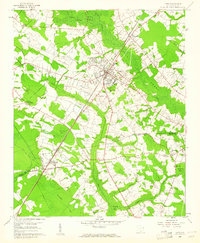 1960 Latta1961 Print · USGSDillon and Marion Counties are captured here in the early 1960s, showing a rural landscape defined by the Atlantic Coast Line railroad. Genealogists can trace family landmarks like Magnolia Cem, Sardis Ch, and the outlying settlement of Temperance Hill.2 unique versions available
 - 1962 Map of Lake View, 1964 Print
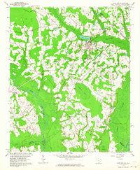 1962 Lake View1964 Print · USGSThe South Carolina and North Carolina borderlands are captured here in the early sixties, showing the transition from old rail corridors to a landscape of millponds and rural crossroads. Genealogists can trace family landmarks like High Hill Crossroads, Pages Millpond, and Squires Pork Church.
 - 1962 Map of Fair Bluff, 1965 Print
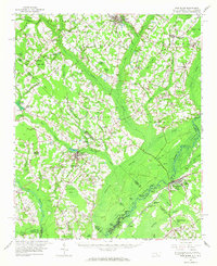 1962 Fair Bluff1965 Print · USGSThe Carolina borderlands near the Lumber River are captured here in the early sixties, showing a landscape defined by elliptical bays and winding swamp systems. Genealogists can trace family names and local sites like Piney Grove Indian Ch, Pages Millpond, and the Atlantic Coast Line Railroad.
 - 1967 Map of Georgetown
 1967 Georgetown1967 Print · USGSThe South Carolina Lowcountry and Grand Strand meet in the late sixties, showcasing a coastal landscape transitioning from river-based industry to seaside tourism. Researchers can trace the Intracoastal Waterway past Georgetown or locate historical sites like Fort Fisher and Murrells Inlet.
End of results
Showing maps 1-4 of 4
Top cities of Marion County
Frequently asked questions
- What are the different types of historical maps available for Marion County?
- What is the oldest map of Marion County?
- Where can I purchase historical maps of Marion County for my home or office?
- Where can I download high-res historical maps of Marion County?
- Are there historical topographic maps available for Marion County?
- Is there historical aerial imagery available for Marion County?
- Where are historical maps of Marion County sourced from?