
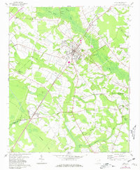
1960 Map of Latta
USGS Topo · Published 1961About this map
Latta serves as the central hub of this 1960 survey, situated at the intersection of the Atlantic Coast Line railroad and several local routes. The landscape is defined by its agricultural character and a dense network of water features, including the Catfish Canal and expansive wetlands like Buck Swamp and Ellerbe Bay. These natural features dictated the placement of settlements and transport lines, with the railroad running through Sellers and past prominent landmarks like the Latta Lookout Tower.
Find a feature on this map
43 named features on this map. Tap any name to fly to it.
Don’t see what you’re looking for? This feature index may not catch every label — zoom into the map to look around manually.
Map Details
Editions of this 1960 Latta Map
2 editions found
Other maps of this area

1940 · Florence East
USGS Topo · 1:62,500

1943 · Gum Swamp
USGS Topo · 1:62,500

1945 · Florence East
USGS Topo · 1:62,500

1946 · Mullins
USGS Topo · 1:24,000

1947 · Marion
USGS Topo · 1:24,000

1947 · Mullins
USGS Topo · 1:24,000

1953 · Florence
USGS Topo · 1:250,000

1954 · Florence
USGS Topo · 1:250,000

1959 · Fork
USGS Topo · 1:24,000

1960 · Dillon East
USGS Topo · 1:24,000