1950s Maps of Charles Mix County, South Dakota
Explore 8 historic maps of Charles Mix County from the 1950s. These maps offer a rare glimpse into what life looked like during the 1950s — showing old roads, neighborhoods, homes, and landmarks that have changed or disappeared over time.
Whether you're researching your family's past, planning a metal detecting trip, or studying how Charles Mix County's landscape evolved across the 1950s, these high-resolution maps are a powerful tool for exploring the history of this region.
- Focus on a specific era: All maps on this page are from the 1950s, giving you a focused view of this time period.
- See what’s changed: Compare century-old streets, trails, and buildings to today's modern landscape using overlays and satellite layers.
- Research with precision: Use these maps for genealogy, historical research, land use analysis, or educational projects.
- View, download, or print: Maps are fully viewable online in high resolution, and can be downloaded or printed for your own records.
Start exploring Charles Mix County's history through authentic maps from the 1950s. This is your window into the past.
Charles Mix County, SD maps
(8)- 1950 Map of Niobrara, 1952 Print
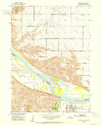 1950 Niobrara1952 Print · USGSThe Missouri and Niobrara rivers converge here in the mid-twentieth century, just as the town of Niobrara prepared for major changes. Genealogists can locate many rural landmarks including Norwegian Cem, Wagner Sch, and the Chicago and North Western rail line.2 unique versions available
 - 1950 Map of Verdel, 1952 Print
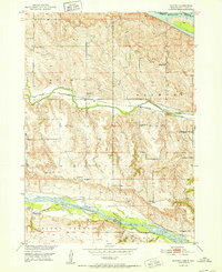
 1950 Verdel1952 Print · USGSThe Missouri River borderlands of Knox County come to life in this mid-century survey of the Verdel area. Local historians can trace the paths of the Chicago and North Western railroad and locate rural landmarks like Clay Hill Sch or Cedar Hill Cem.4 unique versions available
 - 1950 Map of Monowi, 1973 Print
 1950 Monowi1973 Print · USGSNortheastern Nebraska is captured in the mid-1950s at the meeting of the Missouri River and Niobrara River. Genealogists and local historians can locate family sites among numerous rural landmarks like Alford Cem, Monowi, and Masdon Sch.
 - 1952 Map of Monowi
 1952 Monowi1952 Print · USGSThe village of Monowi and the surrounding Nebraska-South Dakota borderlands are captured here in the early 1950s. Genealogists can trace family roots through numerous rural landmarks like Beulah Cem, Pleasant Hill Sch, and the Verdel Sch.2 unique versions available
 - 1955 Map of Mitchell, 1973 Print
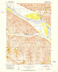
 1955 Mitchell1973 Print · USGSThe Missouri River valley undergoes a massive transformation in the mid-1950s as the Fort Randall Dam creates Lake Francis Case. You can trace the rail lines of the Chicago Milwaukee St Paul and Pacific through Mitchell or locate local landmarks like Butler Town Hall.2 unique versions available
 - 1955 Map of O'Neill, 1974 Print
 1955 O'Neill1974 Print · USGSNorth-central Nebraska in the 1950s reveals a vast cattle-ranching landscape transitioning from the Missouri River breaks to the iconic Sand Hills. Researchers can trace the path of the Chicago and North Western rail line and locate rural landmarks like the Dustin Post Office and St Johns Lake Ch.2 unique versions available
 - 1959 Map of O'Neill
 1959 O'Neill1959 Print · USGSNorth-central Nebraska in the late fifties is defined by the vast Sand Hills and the vital Chicago and North Western rail line. Genealogists and researchers can trace family roots through settlements like Atkinson, Bassett, and Stuart or follow the waters of the Niobrara River.2 unique versions available
 - 1959 Map of Mitchell
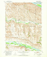
 1959 Mitchell1959 Print · USGSSouth Dakota’s river and rail corridors come alive in the late fifties as the Missouri River valley undergoes dramatic change. Genealogists and historians can trace family roots through numerous small towns and schools such as Academy, Stickney, and Gregory.2 unique versions available
End of results
Showing maps 1-8 of 8
Top cities of Charles Mix County
Frequently asked questions
- What are the different types of historical maps available for Charles Mix County?
- What is the oldest map of Charles Mix County?
- Where can I purchase historical maps of Charles Mix County for my home or office?
- Where can I download high-res historical maps of Charles Mix County?
- Are there historical topographic maps available for Charles Mix County?
- Is there historical aerial imagery available for Charles Mix County?
- Where are historical maps of Charles Mix County sourced from?