
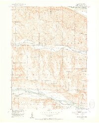
1952 Map of Monowi
USGS Topo · Published 1952About this map
Monowi sits at the heart of this mid-century Missouri River Basin landscape, where the Chicago and North Western railway runs parallel to the winding course of Ponca Creek. This 1950s survey captures a transition in rural education and community structure, evidenced by the high density of country schools including School No 42, School No 89, and the Verdel Sch. The terrain is defined by the three major water systems of the Missouri River to the northeast, the Niobrara River to the south, and the smaller drainage of Steel Creek. Local history and genealogy are anchored by landmarks like Beulah Cem and Alford Cem, which provide specific points of reference for families settled between the township lines. The survey also highlights the boundary between Boyd and Knox Counties, illustrating the administrative divisions of this Nebraska-South Dakota borderland during the postwar period.
Find a feature on this map
25 named features on this map. Tap any name to fly to it.
Don’t see what you’re looking for? This feature index may not catch every label — zoom into the map to look around manually.
Map Details
Editions of this 1952 Monowi Map
2 editions found
Other maps of this area

1950 · Verdel
USGS Topo · 1:24,000

1950 · Dorsey NW
USGS Topo · 1:24,000

1950 · Lynch
USGS Topo · 1:24,000

1950 · Pishelville
USGS Topo · 1:24,000

1950 · Monowi
USGS Topo · 1:24,000

1952 · Dorsey
USGS Topo · 1:24,000

1955 · O'Neill
USGS Topo · 1:250,000

1959 · O'Neill
USGS Topo · 1:250,000

1964 · Lynch NE
USGS Topo · 1:24,000
1964 · Marty
USGS Topo · 1:24,000