1970s Maps of Stanley County, South Dakota
Explore 11 historic maps of Stanley County from the 1970s. These maps offer a rare glimpse into what life looked like during the 1970s — showing old roads, neighborhoods, homes, and landmarks that have changed or disappeared over time.
Whether you're researching your family's past, planning a metal detecting trip, or studying how Stanley County's landscape evolved across the 1970s, these high-resolution maps are a powerful tool for exploring the history of this region.
- Focus on a specific era: All maps on this page are from the 1970s, giving you a focused view of this time period.
- See what’s changed: Compare century-old streets, trails, and buildings to today's modern landscape using overlays and satellite layers.
- Research with precision: Use these maps for genealogy, historical research, land use analysis, or educational projects.
- View, download, or print: Maps are fully viewable online in high resolution, and can be downloaded or printed for your own records.
Start exploring Stanley County's history through authentic maps from the 1970s. This is your window into the past.
Stanley County, SD maps
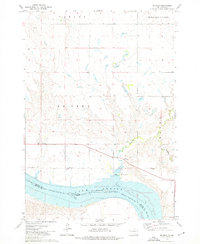
(11)- 1972 Map of Pierre 3 NE, 1975 Print
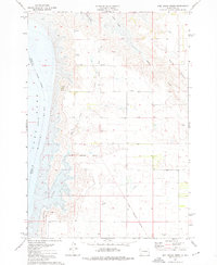
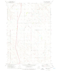 1972 Pierre 3 NE1975 Print · USGSCentral South Dakota ranching country is captured here in the early seventies, showing the sparse but organized landscape of the Missouri River plateau. Genealogists and historians can trace the bounds of Richland and Rowe or locate the remote Landing Strip near Cedar Creek.2 unique versions available
 - 1973 Map of Iron Post Buttes SE
 1973 Iron Post Buttes SE1973 Print · USGSThe Missouri River breaks in the early 1970s reveal a landscape defined by the rising waters of Lake Oahe. Researchers can trace the Old Military Reservation Boundary and locate early recreation sites like the Okobojo Recreation Area and Peoria Flats.
 - 1973 Map of Iron Post Buttes SW, 1976 Print
 1973 Iron Post Buttes SW1976 Print · USGSStanley County land and water are captured here in the early seventies, showing the expansive Lake Oahe along the Missouri River. Researchers can trace the Old Indian Treaty Boundary and locate the Thompson Landing Field among the hills.
 - 1973 Map of Iron Post Buttes, 1976 Print
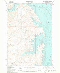 1973 Iron Post Buttes1976 Print · USGSThe Missouri River breaks in Stanley County are captured here just after the completion of the Oahe Dam, showing the reservoir as it appeared in the 1970s. Researchers can trace the rugged shoreline and locate points like Bennett, Iron Post Buttes, and the mouth of Mission Creek.
 - 1973 Map of Pierre, 1976 Print
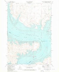
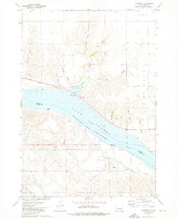
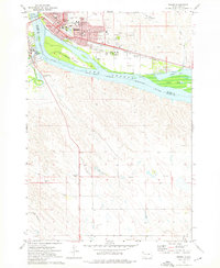 1973 Pierre1976 Print · USGSThe South Dakota capital and Fort Pierre are captured here in the early seventies, flanking the Missouri River at its junction with the Bad River. Genealogists and local historians can trace civic landmarks like the Capitol, the Pierre Indian Sch, and the Riverside Cemetery amidst the river islands and rail lines.
 - 1973 Map of Willow Creek Butte, 1976 Print
 1973 Willow Creek Butte1976 Print · USGSThe Missouri River breaks of Stanley County are captured in the early seventies as the waters of Lake Oahe reshaped the valley. Topographic details reveal the high ground of Willow Creek Butte and the flats at Peoria Flats and Giddings Flat.
 - 1973 Map of De Grey, 1976 Print
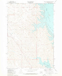
 1973 De Grey1976 Print · USGSHughes County in the 1970s shows the Missouri River bottomlands transformed by the reservoir system of the mid-century. Genealogists and local historians can locate the De Grey Sch, the Ft George Ch, and the rural community of Canning.
 - 1973 Map of Antelope Island, 1976 Print
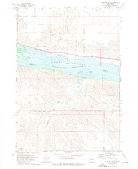 1973 Antelope Island1976 Print · USGSThe Missouri River corridor south of Pierre is captured in the early 1970s as Lake Sharpe reshaped the landscape. Trace the Old Indian Treaty Boundary and the path of the Chicago and North Western rail line near Alto.
 - 1973 Map of Mail Shack Creek, 1976 Print
 1973 Mail Shack Creek1976 Print · USGSSully County, South Dakota, is captured here in the mid-1970s along the expanding waters of the Missouri. Researchers can trace the Old Military Reservation Boundary or locate the Koenig State Public Shooting Area and Sully Buttes.
 - 1973 Map of Rousseau, 1976 Print
 1973 Rousseau1976 Print · USGSThe Missouri River breaks across central South Dakota in the 1970s, showcasing the reservoir landscape of Lake Sharpe. Genealogists and historians can trace the Lower Brule Indian Reservation Boundary and locate the Holy Name Chapel or Rousseau Sch.
 - 1973 Map of Oahe Dam, 1976 Print
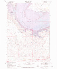
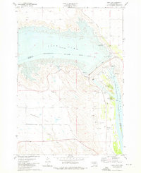 1973 Oahe Dam1976 Print · USGSStanley and Hughes counties were transformed in the early seventies by the massive Missouri River reservoirs created by the Oahe Dam. Researchers can trace the submerged river boundary and find local landmarks like the Scotty Philip Cem, the Old RR Grade, and Singleton Landing Field.
End of results
Showing maps 1-11 of 11
Top cities of Stanley County
Frequently asked questions
- What are the different types of historical maps available for Stanley County?
- What is the oldest map of Stanley County?
- Where can I purchase historical maps of Stanley County for my home or office?
- Where can I download high-res historical maps of Stanley County?
- Are there historical topographic maps available for Stanley County?
- Is there historical aerial imagery available for Stanley County?
- Where are historical maps of Stanley County sourced from?