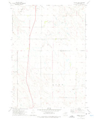
1972 Map of Pierre 3 NE
USGS Topo · Published 1975About this map
Antelope Creek and Gray Blanket Cr meander through the prairie landscape along the shared borders of Stanley and Lyman Counties. This early 1970s survey captures a transition in the rural landscape, marked by the expansive townships of Richland and Rowe. The terrain is defined by the drainage patterns of the Missouri River plateau, with numerous seasonal draws feeding into the primary waterways. A solitary Landing Strip near the banks of Cedar Creek highlights the isolation of this ranching country, where infrastructure is minimal and tied to the vast agricultural stretches of central South Dakota. The map provides a precise look at section lines and county divisions that dictated the settlement and land use of the region during this period.
Find a feature on this map
9 named features on this map. Tap any name to fly to it.
Don’t see what you’re looking for? This feature index may not catch every label — zoom into the map to look around manually.
Map Details
Editions of this 1972 Pierre 3 NE Map
2 editions found
Other maps of this area

1924 · Pierre
USGS Topo · 1:62,500

1934 · Canning
USGS Topo · 1:48,000

1937 · Canning
USGS Topo · 1:62,500

1953 · Pierre SW
USGS Topo · 1:24,000

1953 · Pierre 3 NW
USGS Topo · 1:24,000

1954 · Pierre
USGS Topo · 1:250,000

1958 · Pierre
USGS Topo · 1:250,000

1967 · Ft. George Butte NW
USGS Topo · 1:24,000

1967 · Ft. George Butte SW
USGS Topo · 1:24,000

1972 · Pierre 3 SW
USGS Topo · 1:24,000