1910s Maps of Cumberland County, Tennessee
Explore 2 historic maps of Cumberland County from the 1910s. These maps offer a rare glimpse into what life looked like during the 1910s — showing old roads, neighborhoods, homes, and landmarks that have changed or disappeared over time.
Whether you're researching your family's past, planning a metal detecting trip, or studying how Cumberland County's landscape evolved across the 1910s, these high-resolution maps are a powerful tool for exploring the history of this region.
- Focus on a specific era: All maps on this page are from the 1910s, giving you a focused view of this time period.
- See what’s changed: Compare century-old streets, trails, and buildings to today's modern landscape using overlays and satellite layers.
- Research with precision: Use these maps for genealogy, historical research, land use analysis, or educational projects.
- View, download, or print: Maps are fully viewable online in high resolution, and can be downloaded or printed for your own records.
Start exploring Cumberland County's history through authentic maps from the 1910s. This is your window into the past.
Cumberland County, TN maps
(2)- 1910 Map of Pikeville
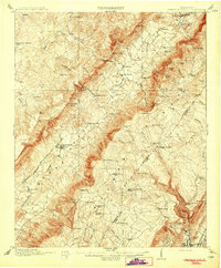 1910 Pikeville1910 Print · USGSBledsoe County at the turn of the century shows a landscape of valley farms and mountain gaps connected by the Nashville Chattanooga and St Louis RR. Researchers can locate early milling sites like Hembree Mill and rural landmarks such as Melvine PO and Saratoga Springs.2 unique versions available
 - 1912 Map of Crossville
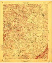 1912 Crossville1912 Print · USGSCumberland County at the start of the twentieth century was a landscape of plateau settlements and developing rail lines. Genealogists and historians can trace early community hubs like Crossville, rural school sites such as Flynn School, and creek-side features like Hinch Mill.2 unique versions available
End of results
Showing maps 1-2 of 2
Top cities of Cumberland County
- Crossville historical maps
- Fairfield Glade historical maps
- Crab Orchard historical maps
- Pleasant Hill historical maps
Frequently asked questions
- What are the different types of historical maps available for Cumberland County?
- What is the oldest map of Cumberland County?
- Where can I purchase historical maps of Cumberland County for my home or office?
- Where can I download high-res historical maps of Cumberland County?
- Are there historical topographic maps available for Cumberland County?
- Is there historical aerial imagery available for Cumberland County?
- Where are historical maps of Cumberland County sourced from?