1900s (20th Century) Maps of Giles County, Tennessee
Explore 60 historic maps of Giles County from the 1900s (20th Century). These maps offer a rare glimpse into what life looked like during the 1900s — showing old roads, neighborhoods, homes, and landmarks that have changed or disappeared over time.
Whether you're researching your family's past, planning a metal detecting trip, or studying how Giles County's landscape evolved across the 1900s, these high-resolution maps are a powerful tool for exploring the history of this region.
- Focus on a specific era: All maps on this page are from the 1900s, giving you a focused view of this time period.
- See what’s changed: Compare century-old streets, trails, and buildings to today's modern landscape using overlays and satellite layers.
- Research with precision: Use these maps for genealogy, historical research, land use analysis, or educational projects.
- View, download, or print: Maps are fully viewable online in high resolution, and can be downloaded or printed for your own records.
Start exploring Giles County's history through authentic maps from the 1900s. This is your window into the past.
Giles County, TN maps
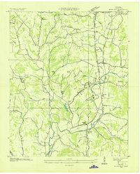
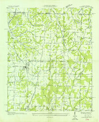
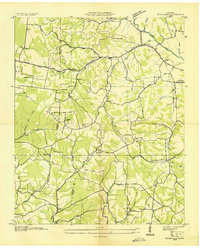
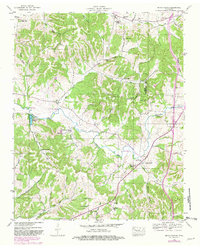
(60)- 1936 Map of Sandy Hook
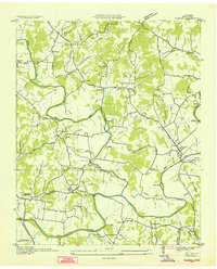
 1936 Sandy Hook1936 Print · USGSThe rural borders of Maury and Giles counties are captured in the mid-thirties as a landscape of small ridges and rail-connected hamlets. Genealogists can trace family names and local landmarks like Scotts Mill, Jonestown, and Ettaton Sch before modern development changed these hills.
 - 1936 Map of Union Hill
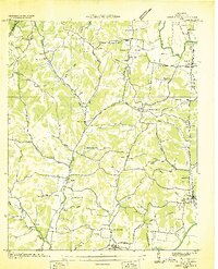
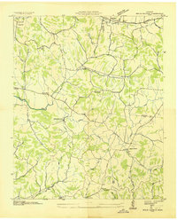
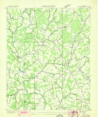
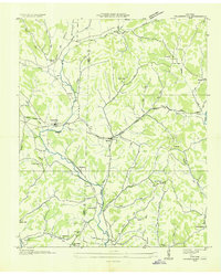
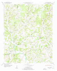
 1936 Union Hill1936 Print · USGSThe Alabama and Tennessee borderlands are captured here in the mid-1930s as modern infrastructure arrived in a landscape of small family farms. Researchers can locate long-standing landmarks like Ridgeways Mill, Hester Cem, and the rural community of Good Springs.
 - 1936 Map of Milky Way
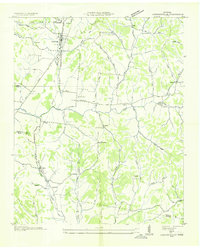
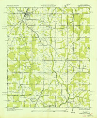
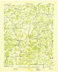
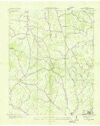
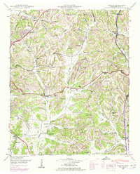
 1936 Milky Way1936 Print · USGSGiles County in the mid-1930s is a landscape of established estates and railroad-dependent hamlets. Researchers can trace family history through numerous landmarks like Milky Way Farm, Riversburg Station, and the Morris Town Cem.
 - 1936 Map of Aspen Hill
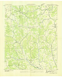
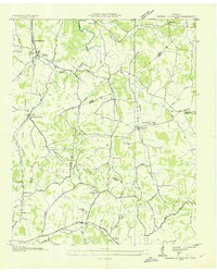
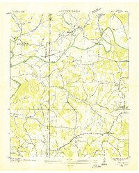
 1936 Aspen Hill1936 Print · USGSGiles County at the mid-thirties is a landscape of rural schoolhouses and family-named hollows connected by the Louisville and Nashville Railroad. You can trace the historic footprint of Aspen Hill and find lost landmarks like Tarpleys Store or Beasley Chapel School.
 - 1936 Map of Cornersville
 1936 Cornersville1936 Print · USGSMarshall County's rural landscape is captured here in the mid-1930s as modern power lines and highways began to intersect with long-established farming communities. Genealogists and local historians can trace the locations of the Gnat Grove Sch, Richland Ch, and small settlements like Graball and Diana.
 - 1936 Map of Campbellsville
 1936 Campbellsville1936 Print · USGSGiles and Lawrence counties are shown here in the mid-1930s, documenting a rural landscape of scattered churches and family cemeteries. Trace the locations of historic community centers like Campbellsville, Rose Hill Sch, and St Matthews Ch.
 - 1936 Map of Elkmont
 1936 Elkmont1936 Print · USGSThe Tennessee-Alabama borderlands come into focus in the mid-1930s, showing a landscape defined by the Louisville and Nashville rail line and rural industry. Genealogists can locate family landmarks like Hays Mill, Holland Gin, and old burial grounds including New Garden Cem.
 - 1936 Map of Brick Church
 1936 Brick Church1936 Print · USGSGiles and Marshall Counties come into focus during the mid-1930s, showing a rural landscape organized around creek valleys and small community hubs. Researchers can locate family landmarks like the Odd Fellows Hall or trace school locations such as Woodlawn Sch and Fairview Sch.
 - 1936 Map of Ardmore
 1936 Ardmore1936 Print · USGSThe Alabama-Tennessee borderlands appear here in the mid-1930s, showing the early growth of ARDMORE along the LOUISVILLE AND NASHVILLE railroad. Genealogists can trace family landmarks like Hatchett Cem and rural school sites such as Wooley Springs Sch.
 - 1936 Map of Campbells Station
 1936 Campbells Station1936 Print · USGSThe rural borderlands of Maury, Marshall, and Giles counties come into focus during the mid-thirties, centered on the Louisville and Nashville rail line. Researchers can trace old family sites and rural centers like Campbells Station, the Ballamfant Cem, and Mooresville Sch.
 - 1936 Map of Pulaski
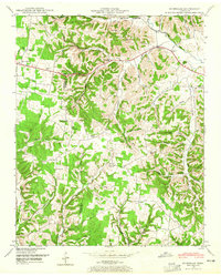
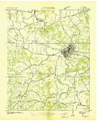 1936 Pulaski1936 Print · USGSGiles County was undergoing a significant transformation in the mid-1930s as modern utilities arrived. Genealogists and historians can trace family roots through Peterson Cem, Goodspring Ch, and numerous rural schoolhouses like Rock City Sch.
 - 1936 Map of Bodenham
 1936 Bodenham1936 Print · USGSGiles and Lawrence Counties appear here in the mid-1930s, showing a landscape of traditional hollows and early electrification. Genealogists can locate family sites like Hughes Cem, Wilburn Chapel, and the settlement of Fall River.2 unique versions available
 - 1936 Map of Appleton
 1936 Appleton1936 Print · USGSGiles and Lawrence Counties are captured here in the mid-1930s, showing a rural landscape of creek-side settlements and family homesteads. Researchers can trace ancestral locations through numerous sites like Powell Cem, Appleton Sch, and Minor Hill.
 - 1936 Map of Tarpley
 1936 Tarpley1936 Print · USGSGiles County in the mid-1930s was a landscape of small upland farms and tightly-knit rural communities. Genealogists and local historians can trace family locations through named sites like Aymett Town, Beech Hill Sch, and Hopkins Cem.
 - 1936 Map of Elkton
 1936 Elkton1936 Print · USGSElkton and the Elk River valley are captured here in the mid-1930s during a period of transition. Genealogists can trace family landmarks like Conway School, the Bethany Cemetery, and early industry at the Vinta Mill.
 - 1936 Map of Frankewing
 1936 Frankewing1936 Print · USGSThe Giles and Lincoln County border in the mid-1930s was a landscape of creek-side hamlets and rail-line commerce. Genealogists can trace family landmarks like Youngs Chapel Cem, Sawyer Cem, and the community at Bee Spring Hill.
 - 1936 Map of Lynnville
 1936 Lynnville1936 Print · USGSThe hills of Giles and Maury counties are captured here in the mid-1930s as the local phosphate industry was active. Genealogists can locate family-named landmarks and institutions like Chaffin Cem, Gipsonville Sch, and the Phosphate Mines.
 - 1936 Map of Dellrose
 1936 Dellrose1936 Print · USGSSouthern Tennessee at the height of the mid-1930s reveals a rural landscape shaped by the ELK RIVER and the LOUISVILLE AND NASHVILLE railroad. Genealogists can locate family landmarks like STONE CEM or Hamiltons Mill and trace the rail line through the unique LUDA TUNNEL.
 - 1936 Map of Salem
 1936 Salem1936 Print · USGSNorthern Alabama in the mid-thirties shows a landscape being reshaped by the rising waters of Wheeler Reservoir. Genealogists can trace early homesteads and family sites like Conniegun Cem and Walnut Grove Ch.
 - 1946 Map of Brick Church, 1981 Print
 1946 Brick Church1981 Print · USGSGiles and Marshall Counties are captured here in the mid-1940s, showcasing a landscape of small rural hamlets and deeply established family cemeteries. Researchers can trace the grounds of Odd Fellows Hall, locate family plots at Kincaid Cem, or find the old Taylor Sch.
 - 1948 Map of Appleton
 1948 Appleton1948 Print · USGSThe rural borderlands of Giles and Lawrence Counties come alive in the late 1940s, showing a landscape of ridge-top farms and creek-side stores. Genealogists can locate family landmarks like Oxford Cem, the Sam Davis Monument, and the Liberty Hill Sch.
 - 1948 Map of Bodenham, 1965 Print
 1948 Bodenham1965 Print · USGSThe Tennessee hills at the Lawrence and Giles county line are captured here in the late 1940s. Researchers can trace rural life through numerous country landmarks like Choate Creek Church, Copperas Sch, and the community at New Prospect.2 unique versions available
 - 1948 Map of Union Hill, 1973 Print
 1948 Union Hill1973 Print · USGSThe Alabama-Tennessee borderlands appear here in the mid-twentieth century as a landscape of small farming hamlets and creek-side industry. Researchers can locate family landmarks like Ridgway Mill, Hester Chapel, and the McCraw Cem along the banks of Sugar Creek.
 - 1948 Map of Tarpley, 1974 Print
 1948 Tarpley1974 Print · USGSGiles County life in the late 1940s centered on hilltop settlements and creek-side farms along Pigeon Roost Creek. Trace family roots at Beech Hill, find old churches like Rocky Mount Ch, and locate the historic Stage Road.2 unique versions available
 - 1948 Map of Salem, 1974 Print
 1948 Salem1974 Print · USGSThe Alabama-Tennessee borderlands appear here in the late 1940s, showing a river-valley landscape being reshaped by the Wheeler Reservoir. Researchers can trace old family footprints at Leggtown, Gourdsville, and the ELK RIVER FISH HATCHERY, alongside numerous rural burial sites like Nelson Cem.
Showing maps 1-25 of 60
Top cities of Giles County
Frequently asked questions
- What are the different types of historical maps available for Giles County?
- What is the oldest map of Giles County?
- Where can I purchase historical maps of Giles County for my home or office?
- Where can I download high-res historical maps of Giles County?
- Are there historical topographic maps available for Giles County?
- Is there historical aerial imagery available for Giles County?
- Where are historical maps of Giles County sourced from?