1940s Maps of Giles County, Tennessee
Explore 13 historic maps of Giles County from the 1940s. These maps offer a rare glimpse into what life looked like during the 1940s — showing old roads, neighborhoods, homes, and landmarks that have changed or disappeared over time.
Whether you're researching your family's past, planning a metal detecting trip, or studying how Giles County's landscape evolved across the 1940s, these high-resolution maps are a powerful tool for exploring the history of this region.
- Focus on a specific era: All maps on this page are from the 1940s, giving you a focused view of this time period.
- See what’s changed: Compare century-old streets, trails, and buildings to today's modern landscape using overlays and satellite layers.
- Research with precision: Use these maps for genealogy, historical research, land use analysis, or educational projects.
- View, download, or print: Maps are fully viewable online in high resolution, and can be downloaded or printed for your own records.
Start exploring Giles County's history through authentic maps from the 1940s. This is your window into the past.
Giles County, TN maps
(13)- 1946 Map of Brick Church, 1981 Print
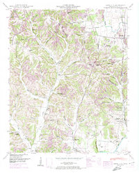
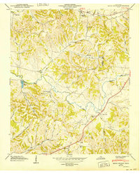
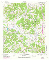 1946 Brick Church1981 Print · USGSGiles and Marshall Counties are captured here in the mid-1940s, showcasing a landscape of small rural hamlets and deeply established family cemeteries. Researchers can trace the grounds of Odd Fellows Hall, locate family plots at Kincaid Cem, or find the old Taylor Sch.
 - 1948 Map of Appleton
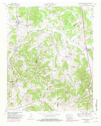
 1948 Appleton1948 Print · USGSThe rural borderlands of Giles and Lawrence Counties come alive in the late 1940s, showing a landscape of ridge-top farms and creek-side stores. Genealogists can locate family landmarks like Oxford Cem, the Sam Davis Monument, and the Liberty Hill Sch.
 - 1948 Map of Bodenham, 1965 Print
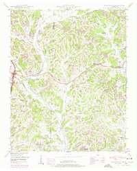
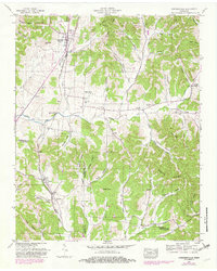
 1948 Bodenham1965 Print · USGSThe Tennessee hills at the Lawrence and Giles county line are captured here in the late 1940s. Researchers can trace rural life through numerous country landmarks like Choate Creek Church, Copperas Sch, and the community at New Prospect.2 unique versions available
 - 1948 Map of Union Hill, 1973 Print
 1948 Union Hill1973 Print · USGSThe Alabama-Tennessee borderlands appear here in the mid-twentieth century as a landscape of small farming hamlets and creek-side industry. Researchers can locate family landmarks like Ridgway Mill, Hester Chapel, and the McCraw Cem along the banks of Sugar Creek.
 - 1948 Map of Tarpley, 1974 Print
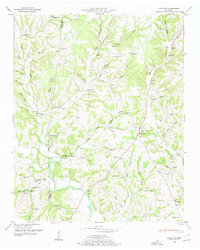
 1948 Tarpley1974 Print · USGSGiles County life in the late 1940s centered on hilltop settlements and creek-side farms along Pigeon Roost Creek. Trace family roots at Beech Hill, find old churches like Rocky Mount Ch, and locate the historic Stage Road.2 unique versions available
 - 1948 Map of Salem, 1974 Print
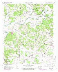
 1948 Salem1974 Print · USGSThe Alabama-Tennessee borderlands appear here in the late 1940s, showing a river-valley landscape being reshaped by the Wheeler Reservoir. Researchers can trace old family footprints at Leggtown, Gourdsville, and the ELK RIVER FISH HATCHERY, alongside numerous rural burial sites like Nelson Cem.
 - 1948 Map of Aspen Hill, 1974 Print
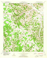
 1948 Aspen Hill1974 Print · USGSGiles County at the edge of northern Alabama was a landscape of ridge-top schools and creek-bottom rail stops just after the war. Family researchers can locate Cedar Grove School, the Louisville and Nashville line, and Prospect Station.
 - 1948 Map of Frankewing, 1975 Print
 1948 Frankewing1975 Print · USGSGiles and Lincoln counties are captured here at mid-century, just as modern road improvements began to reshape the rural landscape. Researchers can trace family history through numerous landmarks like Center Ridge School, Hedgepeth Cem, and the village of Frankewing.2 unique versions available
 - 1948 Map of Dellrose, 1982 Print
 1948 Dellrose1982 Print · USGSLincoln and Giles counties were defined by the winding Elk River and the Louisville and Nashville railroad in the late 1940s. Genealogists and historians can trace family roots through numerous landmarks like Washington Temple, Hamilton Mill, and Young Cem.
 - 1948 Map of Elkton, 1982 Print
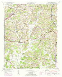
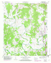 1948 Elkton1982 Print · USGSGiles County settlements and river bends are captured here in the late 1940s as the regional road network expanded. Researchers can locate family landmarks such as Morrell Mill, Antioch Ch, and the numerous cemeteries including Potts Cem and Kelly Cem.
 - 1949 Map of Brick Church
 1949 Brick Church1949 Print · USGSGiles and Marshall counties appear here in the late 1940s, showing a rural landscape defined by ridge-and-hollow farming and small schoolhouse districts. Genealogists can trace family names through numerous sites like Lane Cem, Odd Fellows Hall, and New Zion Ch.3 unique versions available
 - 1949 Map of Campbells Station, 1982 Print
 1949 Campbells Station1982 Print · USGSMid-century Tennessee hill country comes alive here as the LOUISVILLE AND NASHVILLE railroad winds through the ridges of Maury and Marshall counties. Genealogists and historians can trace family landholdings via dozens of sites like Shahe Cem, Mooresville School, and Dodson Siding.
 - 1949 Map of Cornersville, 1982 Print
 1949 Cornersville1982 Print · USGSCornersville and the surrounding Tennessee hill country are captured here at the end of the 1940s as the rail and river economy persisted. Researchers can trace the Louisville and Nashville line and find vanished landmarks like the County farm and New Hope Church.
End of results
Showing maps 1-13 of 13
Top cities of Giles County
Frequently asked questions
- What are the different types of historical maps available for Giles County?
- What is the oldest map of Giles County?
- Where can I purchase historical maps of Giles County for my home or office?
- Where can I download high-res historical maps of Giles County?
- Are there historical topographic maps available for Giles County?
- Is there historical aerial imagery available for Giles County?
- Where are historical maps of Giles County sourced from?