1960s Maps of Hardeman County, Tennessee
Explore 6 historic maps of Hardeman County from the 1960s. These maps offer a rare glimpse into what life looked like during the 1960s — showing old roads, neighborhoods, homes, and landmarks that have changed or disappeared over time.
Whether you're researching your family's past, planning a metal detecting trip, or studying how Hardeman County's landscape evolved across the 1960s, these high-resolution maps are a powerful tool for exploring the history of this region.
- Focus on a specific era: All maps on this page are from the 1960s, giving you a focused view of this time period.
- See what’s changed: Compare century-old streets, trails, and buildings to today's modern landscape using overlays and satellite layers.
- Research with precision: Use these maps for genealogy, historical research, land use analysis, or educational projects.
- View, download, or print: Maps are fully viewable online in high resolution, and can be downloaded or printed for your own records.
Start exploring Hardeman County's history through authentic maps from the 1960s. This is your window into the past.
Hardeman County, TN maps
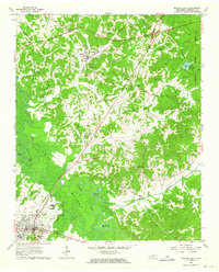
(6)- 1961 Map of Bolivar West, 1963 Print
 1961 Bolivar West1963 Print · USGSHardeman County's river-bottom landscape and rural communities are preserved here as they appeared in the early sixties. Genealogists and local historians can trace family sites like Norment Cem, Bethlehem Ch, and the extensive grounds of Western State Hospital.2 unique versions available
 - 1961 Map of Medon, 1964 Print
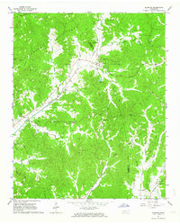
 1961 Medon1964 Print · USGSThe West Tennessee borderlands of Madison, Chester, and Hardeman counties are captured here in the early sixties as a network of rail lines and rural parishes. Genealogists can locate family landmarks like the Rosenwald Sch, Farlow Cem, and Big Springs Ch.3 unique versions available
 - 1961 Map of Silerton, 1964 Print
 1961 Silerton1964 Print · USGSThe Tennessee countryside along the Hardeman and Chester county line is shown here in the early sixties as a region of deep creek bottoms and rail-side hamlets. Researchers can trace rural family sites through numerous landmarks like Coopers Chapel Cem, Old Center Ch, and the small siding at Todd Siding.2 unique versions available
 - 1961 Map of Mercer, 1964 Print
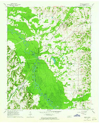 1961 Mercer1964 Print · USGSThe Hatchie River floodplain in the early sixties is a landscape of oxbow lakes and rail-side settlements. Researchers can trace family history at Hayes Chapel Cem, find the site of the Brown Sch, or locate the Old Ferry Landing.2 unique versions available
 - 1961 Map of Bolivar East, 1964 Print
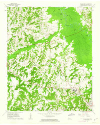
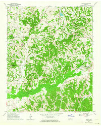
 1961 Bolivar East1964 Print · USGSHardeman County in the early sixties reveals a landscape shaped by the Illinois Central railroad and the winding Hatchie River. Researchers can trace family history through numerous rural landmarks like Toone Cem, Ebenezer Ch, and Lake Lajoie.4 unique versions available
 - 1961 Map of Teague, 1964 Print
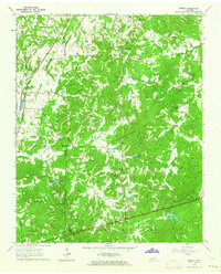
 1961 Teague1964 Print · USGSMadison and Hardeman Counties are shown here in the early sixties, a landscape of family-run farms and traditional country parishes. Genealogists can trace specific family landmarks including Uptonville Cem, Marshall Chapel, and the Indian Mound near Hart Creek.2 unique versions available
End of results
Showing maps 1-6 of 6
Top cities of Hardeman County
- Bolivar historical maps
- Whiteville historical maps
- Middleton historical maps
- Toone historical maps
- Hornsby historical maps
- Hickory Valley historical maps
See more
Frequently asked questions
- What are the different types of historical maps available for Hardeman County?
- What is the oldest map of Hardeman County?
- Where can I purchase historical maps of Hardeman County for my home or office?
- Where can I download high-res historical maps of Hardeman County?
- Are there historical topographic maps available for Hardeman County?
- Is there historical aerial imagery available for Hardeman County?
- Where are historical maps of Hardeman County sourced from?