1940s Maps of Monroe County, Tennessee
Explore 21 historic maps of Monroe County from the 1940s. These maps offer a rare glimpse into what life looked like during the 1940s — showing old roads, neighborhoods, homes, and landmarks that have changed or disappeared over time.
Whether you're researching your family's past, planning a metal detecting trip, or studying how Monroe County's landscape evolved across the 1940s, these high-resolution maps are a powerful tool for exploring the history of this region.
- Focus on a specific era: All maps on this page are from the 1940s, giving you a focused view of this time period.
- See what’s changed: Compare century-old streets, trails, and buildings to today's modern landscape using overlays and satellite layers.
- Research with precision: Use these maps for genealogy, historical research, land use analysis, or educational projects.
- View, download, or print: Maps are fully viewable online in high resolution, and can be downloaded or printed for your own records.
Start exploring Monroe County's history through authentic maps from the 1940s. This is your window into the past.
Monroe County, TN maps
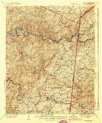
(21)- 1940 Map of Loudon
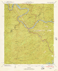
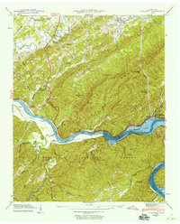
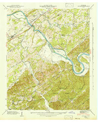
 1940 Loudon1940 Print · USGSTennessee river life and rural industry meet in the early 1940s as the river valley begins to transform. Genealogists and historians can trace family landmarks like Eve-Mills, Huff Ferry, and the Maple Spring Wadkins Cem.
 - 1940 Map of Meadow
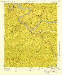
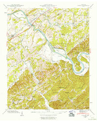
 1940 Meadow1940 Print · USGSLoudon and Blount Counties appear here in the early 1940s, just as the local river-and-rail economy defined daily life. Genealogists and researchers can trace historic river crossings like Morganton Ferry or find rural landmarks like Axley Chapel and Greenback.
 - 1940 Map of Madisonville
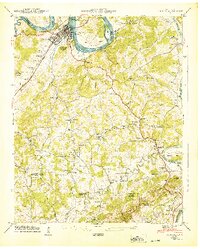
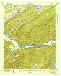
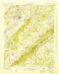
 1940 Madisonville1940 Print · USGSMonroe County at the start of the 1940s reveals a landscape of ridges and creek-fed valleys centered on the rail hub of Madisonville. Researchers can trace old family sites and rural institutions like Hiwassee College, White Cem, and the Sequoyah Sch.4 unique versions available
 - 1940 Map of Philadelphia
 1940 Philadelphia1940 Print · USGSThe Tennessee Valley just before the height of the war era shows a landscape of ridge-top schools and creek-side settlements. Researchers can trace ancestral locations at Philadelphia, the Roberson Cem, and rural centers like New Hope Ch.
 - 1940 Map of Pattie Gap
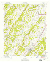
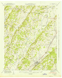
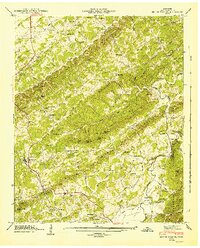
 1940 Pattie Gap1940 Print · USGSThe rural valleys of East Tennessee are captured here in 1940, showing a landscape of small farmsteads and family-named landmarks. Researchers can trace ancestral roots through sites like the Fuller Cem, Morrison Store, and Dry Fork Sch.
 - 1940 Map of Tapoco, 1956 Print
 1940 Tapoco1956 Print · USGSThe Tennessee and North Carolina borderlands come alive in the 1940s as hydroelectric power and federal forest conservation reshape the mountains. Trace historic family sites and early infrastructure including Orr Cemetery, Beers School, and the Calderwood Dam.5 unique versions available
 - 1941 Map of Tapoco
 1941 Tapoco1941 Print · USGSThe Little Tennessee River border between North Carolina and Tennessee is captured here during the 1940s buildup of hydroelectric power. Genealogists and hikers can trace the Appalachian Trail through Deals Gap or locate remote sites like Beers Sch and Orr Cem.
 - 1941 Map of Madisonville
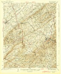
 1941 Madisonville1941 Print · USGSMadisonville and the Tennessee hill country are captured here in the early 1940s as a landscape of small schools, country churches, and railroad commerce. Researchers can trace family roots at Hiwassee College, Hopewell Mill, or the Old Lutheran Cem.
 - 1941 Map of Sweetwater, 1954 Print
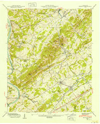
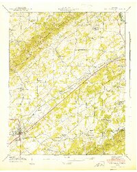
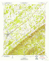
 1941 Sweetwater1954 Print · USGSIn the early 1940s, this Monroe County corridor was a bustling intersection of rail and road transport centered on Sweetwater. Genealogists can trace family roots through numerous country churches and schools like Watson Chapel, Liberality Sch, and Sharps Chapel Sch.
 - 1941 Map of Tallassee, 1959 Print
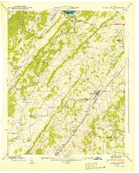
 1941 Tallassee1959 Print · USGSThe Little Tennessee River valley is shown during its mid-century transformation as the rising waters of Chilhowee Lake began to reshape the landscape. Researchers can locate vanished river crossings like Tallassee Ferry and quiet rural centers such as Wellsville or the Citico Sch.
 - 1941 Map of Vonore, 1960 Print
 1941 Vonore1960 Print · USGSThe Little Tennessee River valley comes alive in the early 1940s, showing a landscape of ferry crossings and river islands before modern flooding. Researchers can trace family roots through Toqua Sch, Bacon Ferry, and landmarks like Fort Loudon.5 unique versions available
 - 1941 Map of Niota, 1960 Print
 1941 Niota1960 Print · USGSNiota and the surrounding McMinn County countryside are captured here in the early 1940s, following the path of the Southern Railway. Researchers can trace old agrarian roots at Barton Mill, local landmarks like Beulah Chapel, and small settlements including Prigmore.2 unique versions available
 - 1942 Map of Tallassee
 1942 Tallassee1942 Print · USGSThe Little Tennessee River corridor comes alive in the early 1940s, showing a landscape of mountain gaps and river ferries. Genealogists can trace family sites like Quaker Cem, Williamson Chapel, and river crossings at Tallassee Ferry.
 - 1942 Map of Vonore
 1942 Vonore1942 Print · USGSMonroe County's river valleys are shown here in the early 1940s, just as the Tennessee Valley Authority was reshaping the region's waters. Genealogists can trace family footprints at Shaddon Mill, Montgomery Cem, and the old river crossing at Bacon Ferry.
 - 1942 Map of Sweetwater
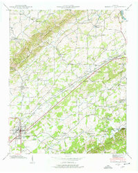
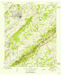
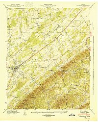
 1942 Sweetwater1942 Print · USGSMonroe and McMinn counties in the early 1940s reveal a landscape of ridge-and-valley farming and early transit corridors. Genealogists can locate family landmarks like West View Cem, Tennessee Military Institute, and rural schools such as Sharps Chapel Sch.2 unique versions available
 - 1942 Map of Niota
 1942 Niota1942 Print · USGSNiota and the surrounding McMinn County valleys are captured here in the early 1940s as a landscape of small farms, railroad stops, and rural industry. Genealogists can locate family landmarks like Shearman Cem, Barton Mill, and the Murray Store.
 - 1943 Map of Tellico
 1943 Tellico1943 Print · USGSThe valleys and mountain foothills of eastern Tennessee appear here in the 1930s and 40s during the height of the rural schoolhouse era. Genealogists can trace family names through dozens of landmarks like Isbell Cem, Union Grove Ch, and schools such as Manila Sch or Hance Sch.2 unique versions available
 - 1943 Map of Ducktown
 1943 Ducktown1943 Print · USGSSoutheast Tennessee mining country is captured here during the 1940s as the regional copper industry reached its peak. Genealogists and historians can trace industrial footprints at the Burra Burra Mine or locate families near Freelingtown and the Ironsburg Sch.2 unique versions available
 - 1944 Map of Englewood, 1960 Print
 1944 Englewood1960 Print · USGSEnglewood and its surroundings at the end of the war show a landscape defined by the Louisville and Nashville railroad and rural valley life. Researchers can trace the Old Federal Road, find small family burial grounds like Cochran Cem, and locate vanished community sites like Manila.4 unique versions available
 - 1945 Map of Englewood, 1946 Print
 1945 Englewood1946 Print · USGSThe rail-and-creek economy of McMinn County is on full display in the 1940s, centered on the growth of Englewood and the rural hills. Researchers can trace family roots at Cochran Cem, visit New Bethel Ch, or locate the site of the old County Farm.
 - 1946 Map of Mount Vernon, 1947 Print
 1946 Mount Vernon1947 Print · USGSMonroe County is shown just after the war, when rural life centered on the local ridges and valley floors. Researchers can trace historic family landmarks such as Belltown Mill, the Tellico Ferry, and cemeteries like Old Prospect Cem.4 unique versions available
End of results
Showing maps 1-21 of 21
Top cities of Monroe County
Frequently asked questions
- What are the different types of historical maps available for Monroe County?
- What is the oldest map of Monroe County?
- Where can I purchase historical maps of Monroe County for my home or office?
- Where can I download high-res historical maps of Monroe County?
- Are there historical topographic maps available for Monroe County?
- Is there historical aerial imagery available for Monroe County?
- Where are historical maps of Monroe County sourced from?