1930s Maps of Rutherford County, Tennessee
Explore 7 historic maps of Rutherford County from the 1930s. These maps offer a rare glimpse into what life looked like during the 1930s — showing old roads, neighborhoods, homes, and landmarks that have changed or disappeared over time.
Whether you're researching your family's past, planning a metal detecting trip, or studying how Rutherford County's landscape evolved across the 1930s, these high-resolution maps are a powerful tool for exploring the history of this region.
- Focus on a specific era: All maps on this page are from the 1930s, giving you a focused view of this time period.
- See what’s changed: Compare century-old streets, trails, and buildings to today's modern landscape using overlays and satellite layers.
- Research with precision: Use these maps for genealogy, historical research, land use analysis, or educational projects.
- View, download, or print: Maps are fully viewable online in high resolution, and can be downloaded or printed for your own records.
Start exploring Rutherford County's history through authentic maps from the 1930s. This is your window into the past.
Rutherford County, TN maps
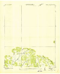
(7)- 1932 Map of Hermitage
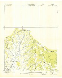
 1932 Hermitage1932 Print · USGSGreater Nashville and its rural eastern reaches come alive in the early 1930s, documenting the river-bend communities and pike roads before modern sprawl. Genealogists can trace family roots through dozens of local landmarks like Woodbine P O, Clover Bottom, and the Andrew Jackson Sch.3 unique versions available
 - 1936 Map of Webbs Jungle
 1936 Webbs Jungle1936 Print · USGSRutherford and Bedford Counties are captured in the mid-1930s, showing a rural landscape defined by the Tennessee Basin Divide. Genealogists and local historians can trace family locations near Webbs Jungle, the Beechwood Ch, and along Wartrace Creek.
 - 1936 Map of Chapel Hill
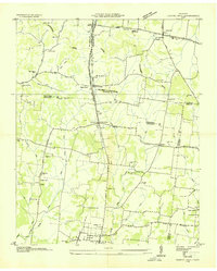 1936 Chapel Hill1936 Print · USGSMiddle Tennessee’s rural landscape is captured here in the mid-1930s as the regional electrical grid was expanding. Researchers can locate vanished landmarks like the Holtland PO, trace family roots at LESTER CEM, or find the old Edwards Grove Ch.
 - 1936 Map of Rover
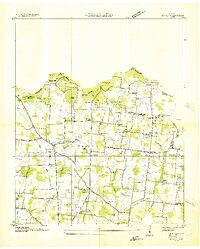 1936 Rover1936 Print · USGSMiddle Tennessee farmland at the Rutherford and Bedford county line is meticulously captured in the mid-thirties. Family historians can trace dozens of burial sites and community centers like Rover, Kingdom Ch, and the Vernon Corner Sch.
 - 1936 Map of Deason
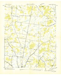 1936 Deason1936 Print · USGSNorthern Bedford County at the peak of the New Deal era reveals a landscape of rural academies and family-named landmarks. Trace ancestral connections at Possumtrot Ch, Harts Chapel, and the historic grounds of Coops Academy.
 - 1936 Map of Beech Grove
 1936 Beech Grove1936 Print · USGSCoffee County rural life in the mid-1930s is detailed here along the winding Garrison Fork and Duck River. Researchers can trace family ties at the Barnes Store, Union Ch, and numerous burial grounds like the Arnold Cem.
 - 1936 Map of Fosterville
 1936 Fosterville1936 Print · USGSThe Rutherford and Bedford county line comes into focus in the mid-1930s as the Tennessee Valley Authority mapped the region's watersheds. Researchers can locate family landmarks such as Woodfin Cem or trace the early paths of U S Highway No 241 and the N C & St L railroad.
End of results
Showing maps 1-7 of 7
Top cities of Rutherford County
- Murfreesboro historical maps
- Smyrna historical maps
- La Vergne historical maps
- Eagleville historical maps
Frequently asked questions
- What are the different types of historical maps available for Rutherford County?
- What is the oldest map of Rutherford County?
- Where can I purchase historical maps of Rutherford County for my home or office?
- Where can I download high-res historical maps of Rutherford County?
- Are there historical topographic maps available for Rutherford County?
- Is there historical aerial imagery available for Rutherford County?
- Where are historical maps of Rutherford County sourced from?