1960s Maps of Rutherford County, Tennessee
Explore 4 historic maps of Rutherford County from the 1960s. These maps offer a rare glimpse into what life looked like during the 1960s — showing old roads, neighborhoods, homes, and landmarks that have changed or disappeared over time.
Whether you're researching your family's past, planning a metal detecting trip, or studying how Rutherford County's landscape evolved across the 1960s, these high-resolution maps are a powerful tool for exploring the history of this region.
- Focus on a specific era: All maps on this page are from the 1960s, giving you a focused view of this time period.
- See what’s changed: Compare century-old streets, trails, and buildings to today's modern landscape using overlays and satellite layers.
- Research with precision: Use these maps for genealogy, historical research, land use analysis, or educational projects.
- View, download, or print: Maps are fully viewable online in high resolution, and can be downloaded or printed for your own records.
Start exploring Rutherford County's history through authentic maps from the 1960s. This is your window into the past.
Rutherford County, TN maps
(4)- 1962 Map of Readyville, 1963 Print
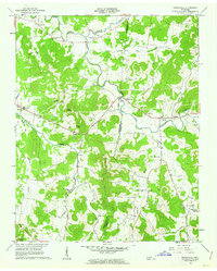 1962 Readyville1963 Print · USGSRutherford and Cannon Counties appear here in the early sixties, showing a landscape of river-valley farms and high knobs. Researchers can trace family sites near Readyville, locate the Drive-in Theater, and find rural landmarks like Antioch Ch and Science Hill Sch.3 unique versions available
 - 1962 Map of Milton, 1963 Print
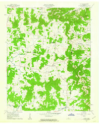 1962 Milton1963 Print · USGSRutherford and Wilson counties met in a landscape of small farms and country churches during the early sixties. Genealogists can trace family footprints through sites like Gloriana Ch, Gaines Cem, and the rural settlements of Milton and Cainsville.3 unique versions available
 - 1966 Map of Deason, 1969 Print
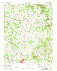 1966 Deason1969 Print · USGSBedford County's rural landscape is captured in the mid-sixties as Shelbyville begins to grow toward the historic settlements of Deason and Vannatta. Researchers can trace family sites like the Houston Whitworth Cem and Erwin Slave Cem or locate the Hart Chapel Ch.2 unique versions available
 - 1968 Map of La Vergne, 1971 Print
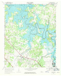 1968 La Vergne1971 Print · USGSIn the late 1960s, the Stones River valley transformed as the J Percy Priest Reservoir rose to its normal pool elevation. Genealogists and local historians can trace the foundations of La Vergne and identify rural landmarks like Burnette Chapel and the Sewart Air Force Base.3 unique versions available
End of results
Showing maps 1-4 of 4
Top cities of Rutherford County
- Murfreesboro historical maps
- Smyrna historical maps
- La Vergne historical maps
- Eagleville historical maps
Frequently asked questions
- What are the different types of historical maps available for Rutherford County?
- What is the oldest map of Rutherford County?
- Where can I purchase historical maps of Rutherford County for my home or office?
- Where can I download high-res historical maps of Rutherford County?
- Are there historical topographic maps available for Rutherford County?
- Is there historical aerial imagery available for Rutherford County?
- Where are historical maps of Rutherford County sourced from?