1950s Maps of Shelby County, Tennessee
Explore 15 historic maps of Shelby County from the 1950s. These maps offer a rare glimpse into what life looked like during the 1950s — showing old roads, neighborhoods, homes, and landmarks that have changed or disappeared over time.
Whether you're researching your family's past, planning a metal detecting trip, or studying how Shelby County's landscape evolved across the 1950s, these high-resolution maps are a powerful tool for exploring the history of this region.
- Focus on a specific era: All maps on this page are from the 1950s, giving you a focused view of this time period.
- See what’s changed: Compare century-old streets, trails, and buildings to today's modern landscape using overlays and satellite layers.
- Research with precision: Use these maps for genealogy, historical research, land use analysis, or educational projects.
- View, download, or print: Maps are fully viewable online in high resolution, and can be downloaded or printed for your own records.
Start exploring Shelby County's history through authentic maps from the 1950s. This is your window into the past.
Shelby County, TN maps
(15)- 1950 Map of Helena
 1950 Helena1950 Print · USGSMid-century Phillips County and the surrounding Delta region are shown at a peak of rail and river commerce. Genealogists and historians can trace family locations through numerous rural communities like Old Austin, Cotton Plant, and West Helena, or follow the routes of the Missouri Pacific RR across Grand Prairie.2 unique versions available
 - 1952 Map of Jericho
 1952 Jericho1952 Print · USGSThe Mississippi River's shifting course defines this borderland during the early 1950s, where Arkansas and Tennessee meet in a maze of chutes and islands. Researchers can trace rural lineages through numerous local sites like St Pauls Ch & Cem, Meneshea, and the Clarkedale Post Office.
 - 1953 Map of Collierville
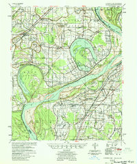
 1953 Collierville1953 Print · USGSThe rural borderlands of Shelby and Fayette counties are captured here in the early fifties, showing a landscape of river bottoms and rail-side hamlets. Genealogists can locate family landmarks like Chambers Chapel & Cem, Hickory Withe Sta, and Morning Sun Ch & Cem.
 - 1953 Map of Memphis, 1966 Print
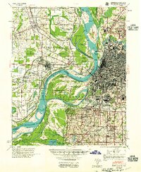
 1953 Memphis1966 Print · USGSEastern Arkansas and the Memphis riverfront are shown here during the mid-century period of regional growth and river management. Local historians can trace the paths of the Chicago Rock Island & Pacific RR through Forrest City or locate river landmarks like President's Island.3 unique versions available
 - 1954 Map of Horseshoe Lake
 1954 Horseshoe Lake1954 Print · USGSThe Mississippi Delta riverfront in the 1950s was a landscape of expansive plantations and river landings. Genealogists can trace family names and community hubs through features like Snowden Plantation, Rosenwald Sch, and Penton Ch & Cem.2 unique versions available
 - 1954 Map of Mason
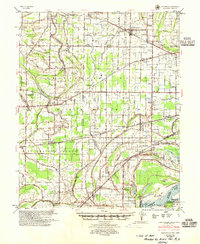
 1954 Mason1954 Print · USGSWest Tennessee in the mid-1950s shows a landscape of rail-linked towns and deep-rooted rural institutions. Genealogists and researchers can trace family connections at the Dunlap Orphanage, Home Ferry Sch, and numerous sites like St Matthews Sch & Ch.
 - 1954 Map of Edmondson, 1955 Print
 1954 Edmondson1955 Print · USGSCrittenden and St. Francis counties in the mid-fifties show a landscape of intricate Delta bayous and growing rural settlements. Genealogists can trace family roots through numerous local landmarks like Truevine Ch & Cem, Greasy Corner, and Crawfordsville.2 unique versions available
 - 1955 Map of Memphis
 1955 Memphis1955 Print · USGSMemphis and its Arkansas neighbors are shown here in the mid-fifties, during a time of major river engineering and rail expansion. Genealogists and historians can trace the foundations of local communities through landmarks like Ensley Plantation, Elmwood Cem, and the rural Riceville Sch.
 - 1955 Map of Helena, 1967 Print
 1955 Helena1967 Print · USGSThe Arkansas Delta and Mississippi floodplains are captured here in the mid-fifties, during a period of expanding flood control and rail commerce. Researchers can trace the extensive Chicago Rock Island and Pacific RR lines and locate sites like the Arkansas State College Experimental Rice Farm or Friars Point.2 unique versions available
 - 1956 Map of Memphis
 1956 Memphis1956 Print · USGSThe Mississippi Delta and the bluffs of West Tennessee meet in the mid-fifties, showing a landscape defined by massive river systems and rail hubs. Researchers can trace the path of Crowleys Ridge or locate vanished river landings near Centennial Island and Island No 35.
 - 1956 Map of Blytheville, 1964 Print
 1956 Blytheville1964 Print · USGSWest Tennessee and the Arkansas Delta come alive in this mid-century survey of the river-and-rail corridor connecting Memphis to Jackson. Genealogists and historians can trace the rail lines of the Louisville and Nashville RR and locate landmarks like Western State Hospital or Fort Pillow State Prison Farm.2 unique versions available
 - 1956 Map of Tupelo, 1967 Print
 1956 Tupelo1967 Print · USGSNortheast Mississippi and parts of Tennessee and Alabama are shown here during the mid-fifties, a time of major reservoir construction and forestry management. Researchers can trace the St Louis-San Francisco RR through Tupelo or locate historic sites like Tishomingo State Park and the University.2 unique versions available
 - 1958 Map of Tupelo
 1958 Tupelo1958 Print · USGSNortheast Mississippi and neighboring Alabama and Tennessee appear here during the late fifties as a region defined by new reservoirs and historic rail lines. Genealogists can trace family locations near Sardis Lake, Woodall Mountain, and the St Louis-San Francisco Ry.
 - 1959 Map of Blytheville
 1959 Blytheville1959 Print · USGSWest Tennessee and Northeast Arkansas meet along the river in the late fifties, during a period of steady industrial and agricultural growth. Genealogists can trace the rail corridors of the Illinois Central through Jackson or explore landmarks like Shiloh National Military Park and Fort Pillow State Prison.
 - 1959 Map of Helena
 1959 Helena1959 Print · USGSThe Arkansas and Mississippi Delta regions are captured here in the late fifties, showing a landscape defined by the Mississippi River and the Grand Prairie. Genealogists and researchers can trace the rail networks of the Illinois Central RR and locate community landmarks like Helena and the White River National Wildlife Refuge.
End of results
Showing maps 1-15 of 15
Top cities of Shelby County
- Memphis historical maps
- Bartlett historical maps
- Collierville historical maps
- Germantown historical maps
- Lakeland historical maps
- Millington historical maps
See more
Frequently asked questions
- What are the different types of historical maps available for Shelby County?
- What is the oldest map of Shelby County?
- Where can I purchase historical maps of Shelby County for my home or office?
- Where can I download high-res historical maps of Shelby County?
- Are there historical topographic maps available for Shelby County?
- Is there historical aerial imagery available for Shelby County?
- Where are historical maps of Shelby County sourced from?