1940s Maps of Shelby County, Tennessee
Explore 5 historic maps of Shelby County from the 1940s. These maps offer a rare glimpse into what life looked like during the 1940s — showing old roads, neighborhoods, homes, and landmarks that have changed or disappeared over time.
Whether you're researching your family's past, planning a metal detecting trip, or studying how Shelby County's landscape evolved across the 1940s, these high-resolution maps are a powerful tool for exploring the history of this region.
- Focus on a specific era: All maps on this page are from the 1940s, giving you a focused view of this time period.
- See what’s changed: Compare century-old streets, trails, and buildings to today's modern landscape using overlays and satellite layers.
- Research with precision: Use these maps for genealogy, historical research, land use analysis, or educational projects.
- View, download, or print: Maps are fully viewable online in high resolution, and can be downloaded or printed for your own records.
Start exploring Shelby County's history through authentic maps from the 1940s. This is your window into the past.
Shelby County, TN maps
(5)- 1942 Map of Millington, 1944 Print
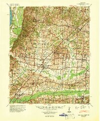 1942 Millington1944 Print · USGSThe Tennessee-Mississippi borderlands come alive in the 1940s, showing the rural communities between the big river and the rail lines. Genealogists can locate family landmarks like St Johns Church & Cem, Rhodes Store, and Bolton.2 unique versions available
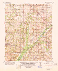
 - 1943 Map of Collierville, 1964 Print
 1943 Collierville1964 Print · USGSThe rural borderlands of Shelby and Fayette counties are captured here in the early 1940s, anchored by the rail hubs of Collierville and Rossville. Genealogists can trace family roots through numerous sites like Augusta Rosenwald Sch, Magnolia Cem, and Morning Sun Ch & Cem.
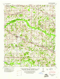
 - 1944 Map of Hernando, 1946 Print
 1944 Hernando1946 Print · USGSDeSoto County communities and the rising waters of the Arkabutla Reservoir are documented here in the mid-1940s. Genealogists can locate family landmarks like Betts Sch Ch & Cemetery, the Drain Family Cem, and old schools in Cockrum or Lewisburg.3 unique versions available
 - 1948 Map of Helena
 1948 Helena1948 Print · USGSEastern Arkansas and the Mississippi Delta are captured here just after the war, showing a landscape defined by its great rivers and rail lines. Genealogists can trace family locations near Bemis Plantation, Helena, and smaller rail stops like Wheatley and Moro.
 - 1948 Map of Byhalia
 1948 Byhalia1948 Print · USGSMarshall County in the late 1940s is captured here as a thriving network of small settlements and rail-side towns. Genealogists and historians can trace family locations through numerous rural landmarks like Shelby Ch & Cem, Red Banks, and the Marshall Inst Ch.3 unique versions available
End of results
Showing maps 1-5 of 5
Top cities of Shelby County
- Memphis historical maps
- Bartlett historical maps
- Collierville historical maps
- Germantown historical maps
- Lakeland historical maps
- Millington historical maps
See more
Frequently asked questions
- What are the different types of historical maps available for Shelby County?
- What is the oldest map of Shelby County?
- Where can I purchase historical maps of Shelby County for my home or office?
- Where can I download high-res historical maps of Shelby County?
- Are there historical topographic maps available for Shelby County?
- Is there historical aerial imagery available for Shelby County?
- Where are historical maps of Shelby County sourced from?