1990s Maps of Shelby County, Tennessee
Explore 9 historic maps of Shelby County from the 1990s. These maps offer a rare glimpse into what life looked like during the 1990s — showing old roads, neighborhoods, homes, and landmarks that have changed or disappeared over time.
Whether you're researching your family's past, planning a metal detecting trip, or studying how Shelby County's landscape evolved across the 1990s, these high-resolution maps are a powerful tool for exploring the history of this region.
- Focus on a specific era: All maps on this page are from the 1990s, giving you a focused view of this time period.
- See what’s changed: Compare century-old streets, trails, and buildings to today's modern landscape using overlays and satellite layers.
- Research with precision: Use these maps for genealogy, historical research, land use analysis, or educational projects.
- View, download, or print: Maps are fully viewable online in high resolution, and can be downloaded or printed for your own records.
Start exploring Shelby County's history through authentic maps from the 1990s. This is your window into the past.
Shelby County, TN maps
(9)- 1990 Map of Helena, 1991 Print
 1990 Helena1991 Print · USGSThe Arkansas and Mississippi delta regions meet here in the 1990s, where the great river's oxbows and islands define the state line. Genealogists and historians can trace the rail networks of the Illinois Central Gulf RR and local settlements like Palestine, Marvell, and La Grange.
 - 1996 Map of Pleasant Hill, 2001 Print
 1996 Pleasant Hill2001 Print · USGSDeSoto County at the turn of the millennium shows the transition from rural crossroads to suburban expansion south of the state line. Genealogists and local historians can trace family locations near Pleasant Hill, Nesbitt, and the old Welch Sta.
 - 1997 Map of Germantown, 1999 Print
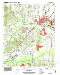
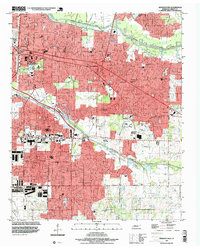 1997 Germantown1999 Print · USGSThe eastern suburbs of Shelby County show significant residential and educational development in the late nineties as Memphis expanded toward Germantown. Researchers can locate family sites near Polk Chapel, the Memphis Memorial Park Cemetery, and established schools such as Lausanne Sch.
 - 1997 Map of Northwest Memphis, 1999 Print
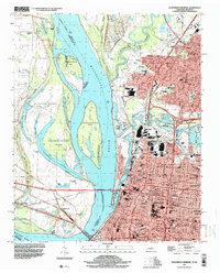 1997 Northwest Memphis1999 Print · USGSThe riverfront and urban expansion of Memphis meet the Arkansas shoreline in the late nineties, documenting a landscape of critical bridges and historic neighborhoods. Genealogists and historians can trace schools and landmarks like Owen College, Green Hill Cem, and St Johns Ch.
 - 1997 Map of Northeast Memphis, 1999 Print
 1997 Northeast Memphis1999 Print · USGSNortheast Memphis and Bartlett are captured here during a period of significant suburban integration and industrial activity in the late nineties. Genealogists and historians can trace institutional roots at the Memphis National Cemetery, Bojo Town, and Spring Hill Cem.
 - 1997 Map of Millington, 1999 Print
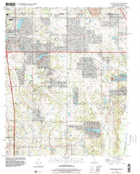
 1997 Millington1999 Print · USGSIn the late 1990s, Millington remained a vital hub of military and aviation activity north of Memphis. Researchers can trace family history through sites like Memorial Garden Cemetery, local schools such as South Sch, and rural communities like Sloanville.
 - 1997 Map of Locke, 2000 Print
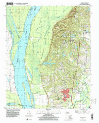 1997 Locke2000 Print · USGSThe bluffs and bottomlands of Shelby County come alive in this late 1990s record of the Mississippi riverfront. Genealogists and local historians can trace rural roots at Benjestown Cem, the Jeter Sch, and small communities like Locke and Giles Town.
 - 1997 Map of Southeast Memphis, 2000 Print
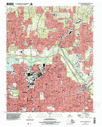
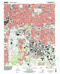 1997 Southeast Memphis2000 Print · USGSSoutheast Memphis and the Capleville area are shown at a peak of late-century urban development, centered on major air and rail hubs. Genealogists and local historians can trace the growth of Parkway Village, locate the Memphis Hebrew Cem, or study the massive Tennessee Yards rail complex.
 - 1997 Map of West Memphis, 2001 Print
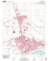 1997 West Memphis2001 Print · USGSCrittenden County at the close of the twentieth century shows the expanding urban footprints of West Memphis and Marion. Researchers can locate local landmarks like the Southland Park Racetrack, Mound City, and the Crittenden Memorial Park (Cem).
End of results
Showing maps 1-9 of 9
Top cities of Shelby County
- Memphis historical maps
- Bartlett historical maps
- Collierville historical maps
- Germantown historical maps
- Lakeland historical maps
- Millington historical maps
See more
Frequently asked questions
- What are the different types of historical maps available for Shelby County?
- What is the oldest map of Shelby County?
- Where can I purchase historical maps of Shelby County for my home or office?
- Where can I download high-res historical maps of Shelby County?
- Are there historical topographic maps available for Shelby County?
- Is there historical aerial imagery available for Shelby County?
- Where are historical maps of Shelby County sourced from?