Old Maps of Memphis, Tennessee for Genealogy
Trace your family roots with 163 historic maps of Memphis. These high-res maps reveal old neighborhoods, homesites, landmarks, and streets — helping you uncover where your ancestors lived and how the area evolved over time.
- Explore historic neighborhoods: Identify where your relatives may have lived in the 1800s or 1900s.
- Compare maps over time: Trace the changes in streets, buildings, and landmarks for multi-generational research.
- Perfect for genealogy & ancestry research: Used by family historians and researchers to map out lineage and migration.
These maps are an incredible resource for exploring your personal connection to Memphis's past.
Memphis, TN maps
(163)- 1908 Map of Lake Cormorant, 1961 Print
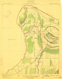
 1908 Lake Cormorant1961 Print · USGSThe Mississippi Delta's shifting landscape is captured here in the early twentieth century, showing a world of river landings and new rail lines. Genealogists and historians can trace the foundations of Lake Cormorant, Glover, and the Morning Star Church.
 - 1912 Map of Lake Cormorant
 1912 Lake Cormorant1912 Print · USGSDeSoto County and the Mississippi-Tennessee border are shown here in the early twentieth century as the rail-and-river economy flourished. Genealogists and local historians can trace the foundations of Lake Cormorant, locate the Morning Star Church, and find river landings like Norfolk Landing.3 unique versions available
 - 1916 Map of Memphis, 1954 Print
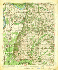
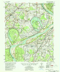
 1916 Memphis1954 Print · USGSMemphis and the Mississippi River bottomlands appear here in the early twentieth century, showing a landscape shaped by river transport and rail expansion. Genealogists and historians can locate rural landmarks like Barton Store, the Levi School, and the community of Mound City.
 - 1925 Map of Memphis
 1925 Memphis1925 Print · USGSThe Memphis riverfront and its Arkansas neighbors are shown here in the mid-1920s as modern highway projects began to parallel the extensive rail network. Genealogists can locate family-named features like Bertons Store, Mound City School, and Plunkett Chapel.
 - 1927 Map of Memphis
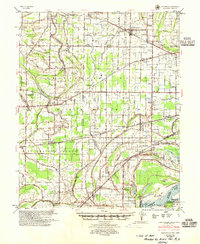
 1927 Memphis1927 Print · USGSMemphis and the Mississippi River bottomlands are captured here in the late twenties during a period of massive rail and river commerce. Genealogists can locate family landmarks like Plunkett Chapel, Levi School, and the Bunker Hill cemetery.2 unique versions available
 - 1931 Map of Horseshoe Lake
 1931 Horseshoe Lake1931 Print · USGSThe Mississippi Delta's shifting landscape is captured here in the early thirties, centered on the great oxbow of Horseshoe Lake. Genealogists and historians can trace family-named tracts like the Tucker Plantation and Seyppel Plantation, alongside rural landmarks like the Y M C A Camp and Robinsonville.
 - 1931 Map of Jericho
 1931 Jericho1931 Print · USGSThe Arkansas-Tennessee borderlands appear here in the early 1930s, defined by the winding Mississippi and its evolving islands. Genealogists and researchers can trace old river landings like Pecan Point, rail stops at Jericho, and the rural Mt Vernon Church.
 - 1932 Map of Horn Lake
 1932 Horn Lake1932 Print · USGSNorthwest Mississippi and the river border come alive in the 1930s as the rail lines and river landings shaped local life. Genealogists can trace family footprints at Howards Store, Bynums Chapel, and Sunrise Sch and Ch near the banks of Horn Lake.3 unique versions available
 - 1935 Map of Horn Lake
 1935 Horn Lake1935 Print · USGSThe Mississippi Delta and Tennessee borderlands meet here in the mid-1930s, showing a landscape of bluff-top farms and river-bottom bayous. Genealogists can trace family roots through dozens of local landmarks like Morning Star Ch, Eudora, and Sunrise Sch.2 unique versions available
 - 1939 Map of Horseshoe Lake, 1941 Print
 1939 Horseshoe Lake1941 Print · USGSThe oxbows and plantations of the Mississippi delta are captured here in the late thirties as the river redefines state boundaries. Genealogists can locate named homesteads and community centers like the Abbey Leatherman Plantation, Robinsonville, and the Hopewell Sch & Ch.2 unique versions available
 - 1939 Map of Jericho, 1941 Print
 1939 Jericho1941 Print · USGSThe shifting Mississippi River bottomlands come to life in this late 1930s survey of the Arkansas-Tennessee border. Researchers can trace historical river landings like Happy Valley Ldg, see the vanished tracks of the St Louis San Francisco RR, and locate rural landmarks such as Mt Olive Ch & Sch.
 - 1939 Map of Edmondson, 1942 Print
 1939 Edmondson1942 Print · USGSCrittenden and St. Francis Counties are shown in the late thirties as a landscape of rail-connected farming towns and bayous. Genealogists can locate family landmarks like Garrett Cem, Macedonia Ch, and the combined Bellmeade Sch & Ch.
 - 1939 Map of Memphis, 1944 Print
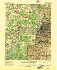 1939 Memphis1944 Print · USGSThe Mississippi River corridor near Memphis and West Memphis is captured here just before mid-century. Researchers can trace the legacy of the riverfront through landmarks like Ensley Plantation, Bridge Junction, and historic grounds at Ross Hill Cem.
 - 1942 Map of Millington, 1944 Print
 1942 Millington1944 Print · USGSThe Tennessee-Mississippi borderlands come alive in the 1940s, showing the rural communities between the big river and the rail lines. Genealogists can locate family landmarks like St Johns Church & Cem, Rhodes Store, and Bolton.2 unique versions available
 - 1943 Map of Collierville, 1964 Print
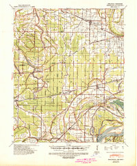
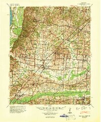
 1943 Collierville1964 Print · USGSThe rural borderlands of Shelby and Fayette counties are captured here in the early 1940s, anchored by the rail hubs of Collierville and Rossville. Genealogists can trace family roots through numerous sites like Augusta Rosenwald Sch, Magnolia Cem, and Morning Sun Ch & Cem.
 - 1944 Map of Hernando, 1946 Print
 1944 Hernando1946 Print · USGSDeSoto County communities and the rising waters of the Arkabutla Reservoir are documented here in the mid-1940s. Genealogists can locate family landmarks like Betts Sch Ch & Cemetery, the Drain Family Cem, and old schools in Cockrum or Lewisburg.3 unique versions available
 - 1948 Map of Helena
 1948 Helena1948 Print · USGSEastern Arkansas and the Mississippi Delta are captured here just after the war, showing a landscape defined by its great rivers and rail lines. Genealogists can trace family locations near Bemis Plantation, Helena, and smaller rail stops like Wheatley and Moro.
 - 1950 Map of Helena
 1950 Helena1950 Print · USGSMid-century Phillips County and the surrounding Delta region are shown at a peak of rail and river commerce. Genealogists and historians can trace family locations through numerous rural communities like Old Austin, Cotton Plant, and West Helena, or follow the routes of the Missouri Pacific RR across Grand Prairie.2 unique versions available
 - 1952 Map of Jericho
 1952 Jericho1952 Print · USGSThe Mississippi River's shifting course defines this borderland during the early 1950s, where Arkansas and Tennessee meet in a maze of chutes and islands. Researchers can trace rural lineages through numerous local sites like St Pauls Ch & Cem, Meneshea, and the Clarkedale Post Office.
 - 1953 Map of Collierville
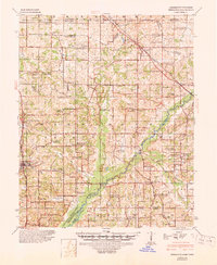
 1953 Collierville1953 Print · USGSThe rural borderlands of Shelby and Fayette counties are captured here in the early fifties, showing a landscape of river bottoms and rail-side hamlets. Genealogists can locate family landmarks like Chambers Chapel & Cem, Hickory Withe Sta, and Morning Sun Ch & Cem.
 - 1953 Map of Memphis, 1966 Print
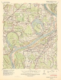
 1953 Memphis1966 Print · USGSEastern Arkansas and the Memphis riverfront are shown here during the mid-century period of regional growth and river management. Local historians can trace the paths of the Chicago Rock Island & Pacific RR through Forrest City or locate river landmarks like President's Island.3 unique versions available
 - 1954 Map of Horseshoe Lake
 1954 Horseshoe Lake1954 Print · USGSThe Mississippi Delta riverfront in the 1950s was a landscape of expansive plantations and river landings. Genealogists can trace family names and community hubs through features like Snowden Plantation, Rosenwald Sch, and Penton Ch & Cem.2 unique versions available
 - 1954 Map of Edmondson, 1955 Print
 1954 Edmondson1955 Print · USGSCrittenden and St. Francis counties in the mid-fifties show a landscape of intricate Delta bayous and growing rural settlements. Genealogists can trace family roots through numerous local landmarks like Truevine Ch & Cem, Greasy Corner, and Crawfordsville.2 unique versions available
 - 1955 Map of Memphis
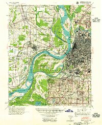 1955 Memphis1955 Print · USGSMemphis and its Arkansas neighbors are shown here in the mid-fifties, during a time of major river engineering and rail expansion. Genealogists and historians can trace the foundations of local communities through landmarks like Ensley Plantation, Elmwood Cem, and the rural Riceville Sch.
 - 1955 Map of Helena, 1967 Print
 1955 Helena1967 Print · USGSThe Arkansas Delta and Mississippi floodplains are captured here in the mid-fifties, during a period of expanding flood control and rail commerce. Researchers can trace the extensive Chicago Rock Island and Pacific RR lines and locate sites like the Arkansas State College Experimental Rice Farm or Friars Point.2 unique versions available
Showing maps 1-25 of 163
Top cities near Memphis
- Bartlett historical maps
- Southaven historical maps
- Germantown historical maps
- Olive Branch historical maps
- Horn Lake historical maps
- West Memphis historical maps
See more
Top neighborhoods of Memphis
- Scaife historical maps
- Hedgemoor historical maps
- Lenox historical maps
- Wells historical maps
- Cordova historical maps
- River Oaks historical maps
See more
Frequently asked questions
- What are the different types of historical maps available for Memphis?
- What is the oldest map of Memphis?
- Where can I purchase historical maps of Memphis for my home or office?
- Where can I download high-res historical maps of Memphis?
- Are there historical topographic maps available for Memphis?
- Is there historical aerial imagery available for Memphis?
- Where are historical maps of Memphis sourced from?